Ptarmigan Traverse
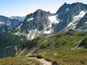


The Ptarmigan Traverse is a famous alpine climbing route in Washington State's North Cascades. The route, from Cascade Pass to Dome Peak, is generally remote, unmarked, and challenging, traversing rugged terrain and several glaciers.
History
The first traverse took 13 days in July 1938. The group consisted of four members of the Ptarmigan Climbing Club: Bill Cox, Calder Bressler, Ray W. Clough, and Tom Myers. The second traverse was in 1953 and consisted of Dale Cole, Bob Grant, Mike Hane, Erick Karlsson and Tom Miller. Miller took high-quality photos of the peaks, valleys, glaciers, and lakes, which were later published in a book by The Mountaineers. The book, called The North Cascades, was published in 1964 and proved instrumental in the bid to create the North Cascades National Park.
The route is named after the alpine bird of the same name. The "p" is silent and is pronounced "TAR-mig-an".
Coleman Leuthy and others made the third successful traverse of the route in the late 1950s. Today the route is a common goal of Cascade Range mountaineers.
Route
Place names are listed from north to south:
Cascade Pass area
- Buckner Peak
- Boston Peak
- Sahale Peak
- Cascade Pass - last improved trail
- Mixup Peak
- Cache Col - boundary between North Cascades National Park and Glacier Peak Wilderness
- Magic Mountain
Middle Cascade area
- Hurry-up Peak
- Middle Cascade Glacier
- Mount Formidable
- Spider Mountain
South Cascade area
- LeConte Mountain
- LeConte Glacier
- Sentinel Peak
- South Cascade Glacier - largest glacier on route after Chickamin Glacier on Dome Peak
- White Rock Lakes
Dome area
References
- Beckey, Fred, Cascade Alpine Guide Volume 2, The Mountaineers Books ISBN 0-89886-152-7
- Karlsson, Erick, "South of Cascade Pass," The Mountaineer, 1953, p. 38
- Miller, Tom, The North Cascades, The Mountaineers, 1964