Prince of Wales Fort
| Prince of Wales Fort | |
|---|---|
| Churchill, Manitoba, Canada | |
|
Prince of Wales Fort | |
 Prince of Wales Fort | |
| Coordinates | 58°47′50″N 94°12′48″W / 58.797158°N 94.213428°W |
| Type | Fortress |
| Site information | |
| Condition | Partially restored |
| Site history | |
| Built | 1717 (log fort) and 1731-1771 |
| In use | 1717-1782 |
| Battles/wars | Hudson Bay expedition (1782) |
| Official name | Prince of Wales Fort National Historic Site of Canada |
| Designated | 1920 |
The Prince of Wales Fort is a historic fort on Hudson Bay across the Churchill River from Churchill, Manitoba, Canada.[1]
History
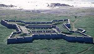
The European history of this area starts with the discovery of Hudson Bay in 1610. The area was recognized as important in the fur trade and of potential importance for other discoveries. The fort is built in a European "star" shape.
Original (wood) fort
This fort began as a log fort built in 1717 by James Knight of the Hudson's Bay Company and was originally called the "Churchill River Post". In 1719, the post was renamed Prince of Wales Fort, but is more commonly known today as Fort Prince of Wales. It was located on the west bank of the Churchill river to protect and control the Hudson's Bay Company's interests in the fur trade.
Construction of the present stone fort
The original wooden fort was replaced by a massive stone fort, perhaps to abide by the Royal Charter which required that Rupert's Land should be fortified. [2]
Construction of this fort, a structure still standing today, was started in 1731 near what was then called Eskimo Point. It was in the form of a square, with sides 100 metres long and walls six metres tall and 10 metres thick at the base.[3]
It had forty-two cannons mounted on the walls. There was also a battery across the river on Cape Merry meant to hold six more cannons.
Work on the fort continued almost without break until 1771, but it was never truly completed.
In battle
In the 1780s, the French government launched a "Hudson Bay Expedition" to damage HBC activities in that bay. Three French warships of the Expedition, led by Jean-François de La Pérouse, captured the Prince of Wales Fort in 1782. The fort was manned by only 39 (non-military) men at the time, and the fort's Governor, Samuel Hearne, recognised the numerical and military imbalance and surrendered without a single shot being fired. The French partially destroyed the fort (but its mostly-intact ruins survive to this day).
The fort returned to the HBC in 1783. Thereafter, its importance waned with the decline in the fur trade although the post was refounded a little way up the river.
.jpg)
Structures
The remains of these buildings still stand in the Fort, although none of them are intact, with roofs long since deteroriated.
- Rough Stone Dwelling House
- Governor's Quarters
- Storehouse
- Men's Quarters and Barracks
- Stonemason's Workshop
- Cooper and Carpenter Workshops
- Tailor's Room
- Blacksmith Shop
The courtyard is intact and all other exposed areas covered by grass.
Restoration
After the construction of the Hudson Bay Railway to Churchill was completed in 1929, railway labour and railway construction equipment was used to restore the fort. Restoration work was also performed in the late 1950s.
Archaeological investigations at and around the fort began in 1958.
Since 2005, Parks Canada archaeologists have been working in and around the fort in conjunction with a large-scale wall stabilization work and a fort interpretation program.
Legacy
In 1920, the site was designated a National Historic Site of Canada.[4]
On 28 June 1985, Canada Post issued 'Fort Prince of Wales, Man.', one of the 20 stamps in the "Forts Across Canada Series". [5] The fort is also the subject of one of the NFB Canada Vignettes.
External links
- Manitoba Historical Society
- Prince of Wales Fort National Historic Site of Canada
- YouTube video of the NFB vignette.
References
| Wikimedia Commons has media related to Prince of Wales Fort. |
- ↑ Charlotte Gray 'The Museum Called Canada: 25 Rooms of Wonder' Random House, 2004
- ↑ J.W. Tyrrell, Across the Sub-Arctics of Canada (1898), p. 215-16
- ↑ J.W. Tyrrell, Across the Sub-Arctics of Canada (1898), p. 215-16. The Canadian Encyclopedia states the Fort is 91 square metres but the writers must mean 91 metres (100 feet) by 91 metres (100 feet) (91 metres square), which is 8300 square metres.
- ↑ Prince of Wales Fort National Historic Site of Canada. Canadian Register of Historic Places. Retrieved 2 October 2013.
- ↑ Canada Post stamp
| Provinces | |
|---|---|
| Territories | |
| Other countries | |
| |