List of National Historic Sites of Canada in the Northwest Territories
This is a list of National Historic Sites of Canada (French: Lieux historiques nationaux du Canada) in the territory of Northwest Territories. There are 12 National Historic Sites designated in the Northwest Territories, of which one (Sahoyúé-§ehdacho) is administered by Parks Canada (identified below by the beaver icon ![]() ).[1][2] The first National Historic Site to be designated in the Northwest Territories was Parry's Rock Wintering Site in 1930.
).[1][2] The first National Historic Site to be designated in the Northwest Territories was Parry's Rock Wintering Site in 1930.
This list uses names designated by the Historic Sites and Monuments Board of Canada, which may differ from other names for these sites.
National Historic Sites
| Site | Date(s) | Designated | Location | Description | Image |
|---|---|---|---|---|---|
| Church of Our Lady of Good Hope [3] | 1885 (completed) | 1977 | Fort Good Hope 66°15′6.84″N 128°38′38.04″W / 66.2519000°N 128.6439000°W |
Early northern Oblate mission church, illustrative of northern mission churches in a simplified version of the Gothic Revival Style; one of the oldest surviving buildings of this type |  |
| Déline Fishery / Franklin's Fort [4] | 1825-7 (wintering site) | 1996 | Deline 65°11′11″N 123°24′57″W / 65.18639°N 123.41583°W |
The archaeological remains of a fort on the site of a traditional seasonal fishery, constructed as the wintering quarters of Sir John Franklin and his second expedition; symbolic of the 19th-century relationship between Aboriginal people in the north and Euro-Canadian exploration parties | |
| Ehdaa [5] | 2002 | Fort Simpson 61°51′33″N 121°20′35″W / 61.85917°N 121.34306°W |
Traditional gathering site for the Dene which continues to be used for important events, including the signing of Treaty 11 in 1921 and Pope John Paul II's visit in 1987 | 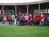 | |
| Fort McPherson [6] | 1840 (established) | 1969 | Fort McPherson 67°26′7″N 134°52′55″W / 67.43528°N 134.88194°W |
The principal Hudson's Bay Company trading post in the MacKenzie Delta region for over 50 years, and a centre of missionary activity; the first North-West Mounted Police post in the Western Arctic | 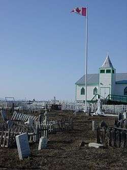 |
| Fort Reliance [7] | 1833 (established) | 1953 | Great Slave Lake 62°42′46″N 109°9′53″W / 62.71278°N 109.16472°W |
The remains of a Hudson’s Bay Company fort built as a base of operations for an expedition by George Back, and later used as a trading post in the 1850s | |
| Fort Resolution [8] | 1819 (established) | 1973 | Fort Resolution 61°10′14″N 113°40′16″W / 61.17056°N 113.67111°W |
A small, rectangular-shaped peninsula on which first stood a North West Company fur post and later a Hudson’s Bay Company store; the oldest continuously occupied place in the Northwest Territories with origins in the fur trade |  |
| Fort Simpson [9] | 1804 (established) | 1969 | Fort Simpson 61°51′36″N 121°20′37″W / 61.86000°N 121.34361°W |
A traditional aboriginal meeting place at the junction of the Liard and Mackenzie Rivers where the North West Company and Hudson's Bay Company constructed trading posts |  |
| Hay River Mission Sites [10] | 1868 (established) | 1992 | Hay River Reserve 60°51′28″N 115°43′26″W / 60.85778°N 115.72389°W |
A complex of mission buildings and associated cemeteries; the missions were located at the centre of a 4,000-kilometre (2,500 mi) inland water route, and are symbolic of the meeting of Dene and European cultures |  |
| Kittigazuit Archaeological Sites [11] | 1400 c.(occupation begins) | 1978 | Inuvik Region 69°20′25″N 133°41′50″W / 69.34028°N 133.69722°W |
An archaeological site on Kittigazuit Island, occupied continuously circa 1400 to 1900 and the location of the largest known seasonal gatherings of Inuit in Northern Canada; traditional Beluga hunting station by the ancestors of today's occupants of Inuvik and Tuktoyaktuk | |
| Nagwichoonjik (Mackenzie River) [12] | 1997 | Tsiigehtchic 67°27′9″N 133°44′54″W / 67.45250°N 133.74833°W |
A cultural landscape of cultural, social and spiritual significance, along the section of the Mackenzie River which traverses the traditional lands of the Gwichya Gwich'in | ||
| Parry's Rock Wintering Site [13] | 1819 (wintering site) | 1930 | Melville Island 74°46′2″N 110°38′8″W / 74.76722°N 110.63556°W |
A large sandstone rock, approximately 5.5 metres (18 ft) long and 3 metres (9.8 ft) high, marking the 1819 wintering site of William Parry's expedition of the Northwest Passage |  |
| Saoyú-ʔehdacho |
1997 | Great Bear Lake 65°20′0.63″N 121°0′5.9″W / 65.3335083°N 121.001639°W |
A sacred site for the Sahtu people; the largest National Historic Site (approximately the size of Prince Edward Island) and the first one designated and acquired through consultation with Aboriginal peoples |
See also
| Wikimedia Commons has media related to National Historic Sites of Canada in the Northwest Territories. |
References
- ↑ "Northwest Territories". Directory of Federal Heritage Designations. Parks Canada. Retrieved 4 October 2013.
- ↑ "Northwest Territories". National Historic Sites of Canada - administered by Parks Canada. Parks Canada. Retrieved 4 October 2013.
- ↑ Church of Our Lady of Good Hope. Canadian Register of Historic Places. Retrieved 4 October 2013.
- ↑ Déline Fishery / Franklin's Fort. Canadian Register of Historic Places. Retrieved 4 October 2013.
- ↑ Ehdaa. Canadian Register of Historic Places. Retrieved 4 October 2013.
- ↑ Fort McPherson. Canadian Register of Historic Places. Retrieved 4 October 2013.
- ↑ Fort Reliance. Canadian Register of Historic Places. Retrieved 8 October 2013.
- ↑ Fort Resolution. Canadian Register of Historic Places. Retrieved 11 October 2013.
- ↑ Fort Simpson. Directory of Federal Heritage Designations. Parks Canada. Retrieved 11 October 2013.
- ↑ Hay River Mission Sites. Canadian Register of Historic Places. Retrieved 22 October 2013.
- ↑ Kittigazuit Archaeological Sites. Canadian Register of Historic Places. Retrieved 22 October 2013.
- ↑ Nagwichoonjik (Mackenzie River). Canadian Register of Historic Places. Retrieved 22 October 2013.
- ↑ Parry's Rock Wintering Site. Canadian Register of Historic Places. Retrieved 22 October 2013.
- ↑ Sahoyúé-§ehdacho. Canadian Register of Historic Places. Retrieved 15 October 2013.
- ↑ "Backgrounder". Signing of Memorandum of Understanding for Permanent Protection of Sahoyúé §ehdacho National Historic Site of Canada. Parks Canada. 11 March 2007. Archived from the original on 11 October 2013. Retrieved 11 October 2013.
| Provinces | |
|---|---|
| Territories | |
| Other countries | |
| |
This article is issued from Wikipedia - version of the 8/10/2015. The text is available under the Creative Commons Attribution/Share Alike but additional terms may apply for the media files.