Prakashpur
| Prakashpur प्रकाशपुर | |
|---|---|
| Village development committee | |
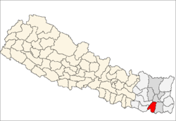
 Prakashpur Location in Nepal | |
| Coordinates: 26°41′17″N 87°05′59″E / 26.6881500°N 87.0997100°ECoordinates: 26°41′17″N 87°05′59″E / 26.6881500°N 87.0997100°E | |
| Country |
|
| Zone | Koshi Zone |
| District | Sunsari District |
| Population (1991) | |
| • Total | 11,110 |
| • Ethnicities | Chhetri,Maeshi,Limbu, Rai , Bramhan, Bishwakarma Magar, Gurung, Tamang,Tharu,Pariyar |
| Time zone | Nepal Time (UTC+5:45) |
Prakashpur is a village development committee in Sunsari District in the Kosi Zone in southeastern Nepal. It is near the Indo-Nepal border.
At the time of the 1991 Nepal census, Prakashpur had a population of 11,110 people living in 1987 households, primarily employed in agriculture.[1]
Geography

Prakashpur city is near the Indo-Nepal-China Tibet border, south of Mount Everest, Southwest of Dharan, in Sunsari district of Koshi zone, Nepal. The VDC is bounded by Mahendranagr to the north, Bhokraha to the south, Dumraha to the east, and Madhuban to the west. It is bisected by the Koshi River, with the western half of the VDC being part of the Koshi Tappu Wildlife Reserve.
Transportation
The main routes to Prakashpur are:
- Inaruwa-Bhokraha-Prakashpur Road (13 km)
- Prakashpur-Mahendranagar-Nadaha-Dharan (30 km) Approx.
- Prakashpur-Singiya-Jhumka-Pakali-Itahari (via Ramdhuni Temple) (17 km)
- Loukahi-Madhuban-Prakashpur-Rajabas-Mahendranagar-Chatara (Barahachhetra-New Saptakoshi Bridge-Barahachhetra Temple
Health
Prakashpur Health Post is a Government Body charge with providing health services.
Governance
Prakashpur is controlled by the Nepalese Government.
Notables
References
- ↑ "Nepal Census 2001". Nepal's Village Development Committees. Digital Himalaya. Retrieved 2 December 2008.