Itahari
| Itahari इटहरी Eastern Heart | |
|---|---|
| Sub-Metropolitan City | |
|
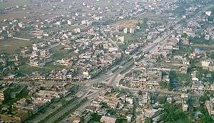
Aerial view of Itahari | |
 Itahari Location in Nepal | |
| Coordinates: 26°40′N 87°17′E / 26.667°N 87.283°ECoordinates: 26°40′N 87°17′E / 26.667°N 87.283°E | |
| Country |
|
| Zone | Koshi Zone |
| District | Sunsari District |
| Government | |
| • Type | Sub-metropolitan City |
| Area | |
| • Total | 87.3301 km2 (33.7183 sq mi) |
| Population (2011) | |
| • Total | 140,801 |
| Time zone | NST (UTC+5:45) |
| Postal Code | 56705 |
| Area code(s) | 025 |
| Website | http://itaharimun.gov.np |

Itahari (Nepali: इटहरी ) is a city located in the Sunsari District ( province no.1 ) in the Koshi Zone of south-eastern Nepal. Itahari lies between major cities in the east such as Biratnagar, Dharan, Damak and Inaruwa.
Itahari is a Sub-Metropolitan, one of the largest and rapidly developing and green city of Sunsari District in the Koshi Zone of south-eastern Nepal. It is the center of the east-west Mahendra Highway and north-south Koshi Highway and thus is a town of emerging importance.It is considered as the main transportation junction of eastern Nepal. At the time of the 2011 Nepal census it had a population of 1,40,517 people living in 33,794 individual households. In 2071, 16th of Mangsir Itahari was declared as sub-metropolitan city combining the VDCs like Khanar, Ekamba, Hasposa and Pakali.
Itahari has also started to become a hub for the business, educational institutions, health facilites, entertainment parks and so on.
History
Government
Demography
Ethnic groups
Itahari is a mixed and multi-culturally diverse city.
See also
References
External links
| Wikimedia Commons has media related to Itahari. |