Praia do Inatel
Praia do Inatel is a Blue flag[1] beach located in the resort town of Albufeira, Algarve, Portugal.[2] The beach lies to the east of Albufeira old town in the district of Bairro dos Pescadores (Neighborhood of the Fisherman),
and is dominated by the Albufeira Inatel Hotel which sit to the rear of the beach and from which the beach takes its name.[3]
Description
The beach is approximately 800 meters in length and is 450 meters wide at low tide.[4] The western boundary of the beach is situated at a concrete pier which covers the outflow of the Ribeira de Albufeira (Albufeira River).[5] At the eastern boundary the beach merges with the neighbouring beach of Praia dos Alemães. The beach is in easy walking distance of the many Hotels and holiday accommodation located in the eastern suburbs of the old town. There is no dedicated parking[6] for the beach although spaces can be found in the Avenida Infante Dom Henrique which runs adjacent to the rear of the beach. There are two licensed bar, restaurant concessions along the beach. there are toilet and shower facilities and there are opportunities to hire parasols and sun loungers. During the summer months the beach is patrolled by lifeguards. [7] There is also a raised board walk running in front of the Inatel hotel and a small section in front of the western beach concession.
Gallery
| The INATEL Albufeira Hotel which dominates the rear of the beach and from where the beach derives its name |
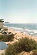
| The western end of the beach with the boundary marked by the concrete pier which covers the outflow of the Ribeira de Albufeira. |
| The beach as it was in 1985 before the renovation of the Hotel. |
| The raised board walk running in front of the western beach concession which includes the hire of parasols and sun loungers. |
| Looking to the west along the beach from the cliff top. |
|
Neighbouring Beach locations
References
- ↑ "Blue Flag - INATEL". Praia dos INATEL's listing on the Blue Flag listing site. The Foundation for Environmental Education. Retrieved 17 April 2015.
- ↑ The Algarve. Sheet Map showing the Praia dos Aveiros location – Grid L6. Rough guides – Penguin Group. 2010. ISBN 9781848364981.
- ↑ "Praia do INATEL". References to the dervived name of INATEL from the Hotel - In Portuguese. Play Ocean ©2015. Retrieved 17 April 2015.
- ↑ "Map - Praia do INATEL" (PDF). Map of the extent of Praia do INATEL with a scale - PDF format. Instituto da Agua - Portuguese Environment Agency. Retrieved 17 April 2015.
- ↑ "Praia do INATEL". References to the Ribeira de Albufeira concrete pier- In Portuguese. Play Ocean ©2015. Retrieved 17 April 2015.
- ↑ "PRAIA DO INATEL". list of the beach facilities - In Portuguese with symbols. Serviço de Apontadores Portugueses – SAPO – na Universidade de Aveiro. Retrieved 16 April 2015.
- ↑ "Instituto de Socorros a Náufragos". information on the Portuguese Lifeguard Service. International Life Saving Federation. Retrieved 16 April 2015.
Beaches of the Algarve |
|---|
|
Algarve
(West to East) | | |
|---|
_(9953023346).jpg)


_(10081311895).jpg)
_(10016832235).jpg)
_(10081314685).jpg)