Poteau River
| Poteau River | |
|---|---|
| Country | United States |
| Basin | |
| Main source | Waldron, Oklahoma |
| River mouth | Fort Smith, Arkansas |
| Physical characteristics | |
| Length | 141 miles |

The Poteau River is a 141-mile (227 km)[1] long river located in the U.S. states of Arkansas and Oklahoma. It is the only river in Oklahoma that flows north[2] and is the seventh largest river in the state. It is a tributary of the Arkansas River, which itself is a tributary of the Mississippi River.
Etymology
Poteau is the French word for "post" and it is believed that the river was named by French explorers who used a post or stake to mark the mouth of the river.[3] The nearby city of Poteau, Oklahoma takes its name from the river.[4]
Course
The Poteau River originates 2 miles (3.2 km) south of Bee Mountain near Waldron, Oklahoma and converges with the Arkansas River at Belle Point in Fort Smith, Arkansas, where it serves as a border between the two states for a short distance. Tributaries of the Poteau River include the Fourche Maline, Brazil and Sans Bois Creeks.[5] Notable towns located along the river, in order from source to mouth, include Wister, Heavener, Poteau, Panama, Spiro, Fort Coffee (all in Oklahoma) and Fort Smith in Arkansas.
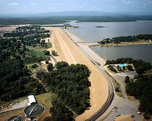
Lake Wister
Lake Wister is a reservoir created by the damming of the Poteau River near river mile 70 by Wister Dam which was built in December 1949. Lake Wister State Park has since been built around the reservoir. The lake and dam both take their name from the nearby town of Wister, Oklahoma.
Oklahoma Runestones
Numerous runestones have been found in Oklahoma and are believed by locals to be the works of Viking explorers who traveled up the Poteau River after navigating the Mississippi and Arkansas Rivers, respectively. The evidence surrounding these claims is sparse and inconsistent, however.
The most credible artifact discovered is the "Heavener Runestone," which can be seen in Heavener Runestone Park located in Heavener, Oklahoma.
References
- ↑ U.S. Geological Survey. National Hydrography Dataset high-resolution flowline data. The National Map, accessed June 3, 2011
- ↑ Corps Lakes Gateway: Oklahoma - Wister Lake
- ↑ Wright, Muriel H. "Some Geographic Names of French Origin in Oklahoma." Chronicles of Oklahoma Volume7, Number 2. June, 1929. Accessed March 26, 2016.
- ↑ "History". City of Poteau, Oklahoma. Retrieved 7 July 2014.
- ↑ Everett, Dianna. "Latimer County," Encyclopedia of Oklahoma History and Culture, Oklahoma Historical Society, 2009. Accessed March 28, 2016.
Coordinates: 35°23′15″N 94°26′03″W / 35.38750°N 94.43417°W