Pollock, Missouri
| Pollock, Missouri | |
|---|---|
| Village | |
|
Former U.S. Post Office in Pollock | |
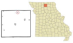 Location of Pollock, Missouri | |
| Coordinates: 40°21′32″N 93°5′3″W / 40.35889°N 93.08417°WCoordinates: 40°21′32″N 93°5′3″W / 40.35889°N 93.08417°W | |
| Country | United States |
| State | Missouri |
| County | Sullivan |
| Area[1] | |
| • Total | 0.17 sq mi (0.44 km2) |
| • Land | 0.17 sq mi (0.44 km2) |
| • Water | 0 sq mi (0 km2) |
| Elevation | 994 ft (303 m) |
| Population (2010)[2] | |
| • Total | 89 |
| • Estimate (2012[3]) | 87 |
| • Density | 523.5/sq mi (202.1/km2) |
| Time zone | Central (CST) (UTC-6) |
| • Summer (DST) | CDT (UTC-5) |
| ZIP code | 63560 |
| Area code(s) | 660 |
| FIPS code | 29-58898[4] |
| GNIS feature ID | 0735801[5] |

Pollock is a village in Sullivan County, Missouri, United States. The population was 89 at the 2010 census.
History
Pollock was established in July, 1873 by H.F. Warner and William Lane and originally consisted of thirty-two blocks. Another fourteen blocks, located south of the original, was added to the town plat in 1876 via Godfrey's Addition.[6]
By 1877 Pollock included two general stores, a drug store, blacksmith shop, one hotel, a schoolhouse and a small depot for the Burlington & Southwestern Railroad with a town population of one hundred,[7] and a United States Post Office was established in Pollock in 1879. A major fire swept through a portion of the Pollock business district in January, 1936. Three buildings—Rosenberry's Garage, Morlan General Store, and Anspach Cafe' -- were total losses, while buildings containing O.L. Casto's store and Miller's Store received major damage.
The Pollock community had a high school between 1923 and 1939. Class sizes were predictable small considering the towns population, with an average of ten students per class year. The smallest class was 1938 with only three graduates, while the largest was the Class of 1937 with thirteen diploma recipients. Due to economic conditions the junior and senior years were discontinued between 1932 and 1937, and students in those grades had to finish their education elsewhere, primarily Milan, which was readily accessible via rail.[8] The Pollock high school closed for good following the 1939 graduation and all secondary students incorporated into the Milan school district. The elementary school continued a few years longer into the mid 1950s. Currently all children in the Pollock area attend classes in the Milan C-2 school district.
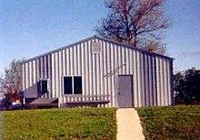
In the mid-1970s, not long after Pollock celebrated its centennial, eight new apartments—housed in two buildings—were constructed for use by the elderly. A new all-metal community building was constructed in the late 1980s, with an addition to the building to house the U.S. Post Office built in the late 1990s. Significant community support resulted in the building of a Pollock City Park around 1990. Residents William Casteel, Melvin Casto and Dick Stewart spearheaded a fundraising campaign and recruited volunteers from far and wide to acquire park equipment and prepare the grounds. Pollock suffered a significant blow on July 26, 2011 when the United States Postal Service announced plans to permanently close the Pollock post office as part of a nationwide restructuring plan.[9] An earlier attempt in the late 1980s to close the Pollock post office was appealed and overturned with the help of U.S. Senator Kit Bond and other Missouri politicians.
Notable residents
- Albert Barry Scobee—Newspaper reporter and publisher, Western fiction writer. Served a key role in the preservation of Old Fort Davis, Texas a frontier outpost during the 1800s. Nearby Barry Scobee Mountain was named in his honor by Texas Governor John Connally in 1964.[10] Scobee was born in Pollock in 1885. Scobee Cemetery, just west of Pollock, is named for his family.
Geography
Pollock is located at 40°21′32″N 93°05′03″W / 40.359023°N 93.084303°W.[11] According to the United States Census Bureau, the village has a total area of 0.17 square miles (0.44 km2), all of it land.[1]
Demographics
| Historical population | |||
|---|---|---|---|
| Census | Pop. | %± | |
| 1980 | 102 | — | |
| 1990 | 66 | −35.3% | |
| 2000 | 131 | 98.5% | |
| 2010 | 89 | −32.1% | |
| Est. 2015 | 85 | [12] | −4.5% |
2010 census
As of the census[2] of 2010, there were 89 people, 39 households, and 25 families residing in the village. The population density was 523.5 inhabitants per square mile (202.1/km2). There were 49 housing units at an average density of 288.2 per square mile (111.3/km2). The racial makeup of the village was 94.4% White, 1.1% African American, 3.4% from other races, and 1.1% from two or more races. Hispanic or Latino of any race were 6.7% of the population.
There were 39 households of which 25.6% had children under the age of 18 living with them, 43.6% were married couples living together, 10.3% had a female householder with no husband present, 10.3% had a male householder with no wife present, and 35.9% were non-families. 33.3% of all households were made up of individuals and 18% had someone living alone who was 65 years of age or older. The average household size was 2.28 and the average family size was 2.84.
The median age in the village was 43.5 years. 24.7% of residents were under the age of 18; 11.3% were between the ages of 18 and 24; 15.7% were from 25 to 44; 31.5% were from 45 to 64; and 16.9% were 65 years of age or older. The gender makeup of the village was 49.4% male and 50.6% female.
2000 census
As of the census[4] of 2000, there were 131 people, 54 households, and 36 families residing in the village. The population density was 786.8 people per square mile (297.5/km²). There were 62 housing units at an average density of 372.4/sq mi (140.8/km²). The racial makeup of the village was 99.24% White, 0.76% from other races. Hispanic or Latino of any race were 1.53% of the population.
There were 54 households out of which 27.8% had children under the age of 18 living with them, 48.1% were married couples living together, 11.1% had a female householder with no husband present, and 33.3% were non-families. 31.5% of all households were made up of individuals and 13.0% had someone living alone who was 65 years of age or older. The average household size was 2.43 and the average family size was 2.83.
In the village the population was spread out with 27.5% under the age of 18, 13.0% from 18 to 24, 22.1% from 25 to 44, 19.8% from 45 to 64, and 17.6% who were 65 years of age or older. The median age was 34 years. For every 100 females there were 81.9 males. For every 100 females age 18 and over, there were 93.9 males.
The median income for a household in the village was $18,571, and the median income for a family was $31,875. Males had a median income of $33,750 versus $18,750 for females. The per capita income for the village was $10,367. There were 29.7% of families and 35.2% of the population living below the poverty line, including 33.3% of under eighteens and 26.3% of those over 64.
References
- 1 2 "US Gazetteer files 2010". United States Census Bureau. Retrieved 2012-07-08.
- 1 2 "American FactFinder". United States Census Bureau. Retrieved 2012-07-08.
- ↑ "Population Estimates". United States Census Bureau. Retrieved 2013-05-30.
- 1 2 "American FactFinder". United States Census Bureau. Retrieved 2008-01-31.
- ↑ "US Board on Geographic Names". United States Geological Survey. 2007-10-25. Retrieved 2008-01-31.
- ↑ History of Adair, Sullivan, Putnam and Schuyler Counties. Published by Goodspeed Publishing, Chicago Il., 1888 p.194
- ↑ "List of Sullivan County communities". Sullivan County Missouri.com. 2009. Retrieved 2011-07-13.
- ↑ Graduating Classes of Sullivan County, Missouri: 1891-1993, Published by The Milan Standard newspaper, July 1993
- ↑ "Expanded Access List". U.S. Postal Service. 2011-07-26. Retrieved 2011-07-26.
- ↑ "Barry Scobee Mountain". TXGenWebProject. Retrieved 2011-04-26.
- ↑ "US Gazetteer files: 2010, 2000, and 1990". United States Census Bureau. 2011-02-12. Retrieved 2011-04-23.
- ↑ "Annual Estimates of the Resident Population for Incorporated Places: April 1, 2010 to July 1, 2015". Retrieved July 2, 2016.
- ↑ "Census of Population and Housing". Census.gov. Retrieved June 4, 2015.
Municipalities and communities of Sullivan County, Missouri, United States | ||
|---|---|---|
| Cities | 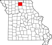 | |
| Villages | ||
| CDP | ||
| Unincorporated communities | ||
| Footnotes | ‡This populated place also has portions in an adjacent county or counties | |