Plotting room
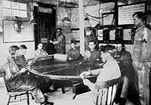
A plotting room (see photo at top right) was used by the U.S. Army Coast Artillery Corps and the Coastal Forces of the Royal Canadian Navy to house a team of soldiers who were engaged in controlling fire for the guns of a coastal artillery battery.[1][2]
Plotting rooms were (and continue to be) used aboard ships to control fire for naval guns, but this use is not described here.
A plotting room was connected by telephone lines (and sometimes by radio) to base end stations (at left, top) that observed the locations of enemy ships and sent data to plotting room soldiers who used equipment like a plotting board to calculate where the guns should be pointed and when they should be fired.
Telephone lines also ran from the plotting room to the guns and were used to relay firing data. Other devices, like range correction boards or deflection boards, were used in the plotting room to calculate corrected firing data or to adjust range and azimuth after spotters in remote observing stations had seen where prior shots had fallen.[3]
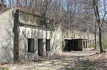
Plotting rooms were sometimes made of concrete and buried below ground (for protection) or were located in the reinforced concrete casemates of Coast Artillery batteries. The casemated version shown at left was built into the side of a sloping embankment near its mortar battery.
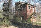
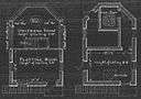
Plotting rooms were also located in free-standing structures, either low towers (like two-story tower from 1904 shown in a photo and in plan view at right) or one- or two-story wood and plaster buildings which might house facilities for several batteries right next to each other in barracks-like structures. These multiple-battery installations might also have sleeping quarters and latrine facilities built nearby.
Sometimes plotting rooms were located hundreds of yards from the batteries they controlled. They often sat on top of nearby hills or ridge lines.[4]
See also
- Gun Data Computer These electro-mechanical computers were introduced into the Coast Artillery in the 1940s, particularly in the new 100- and 200-series 16-inch and 6-inch gun batteries that became operational during that period. Some of these computers received data directly from communicators that were connected to observation instruments in fire control stations or from Coast Artillery radar equipment.
- Coast Artillery fire control system
References
- ↑ Plotting rooms were in use from about 1895 through the end of WW2, at which point the U.S. Coast Artillery was disbanded.
- ↑ In some newer Coast Artillery batteries during World War II, these rooms were called Plotting, Spotting, and Radio (PSR) rooms, and were often (but not always) integrated with the bunkers at the battery that were also used for ammunition storage, electrical generators, and other support functions.
- ↑ For a complete description of fire control in the Coast Artillery, including explanations of the various fire control devices mentioned here, see "FM 4-15 Coast Artillery Field Manual-Seacoast Artillery Fire Control and Position Finding," U.S. War Department, Government Printing Office, Washington, 1940.
- ↑ For an example of a remotely located plotting room, see the map of Fort Andrews and the plotting rooms for mortar batteries Whitman and Cushing atop the western hill that overlooked both batteries, some 700 ft. distant from them.
Bibliography
- Berhow, Mark A., Ed. (2015). American Seacoast Defenses, A Reference Guide, Third Edition. McLean, Virginia: CDSG Press. ISBN 978-0-9748167-3-9.
External links
- Coast Defense Study Group website
- FM 4-15, Seacoast Artillery Fire Control and Position Finding