Piqua, Kentucky
| Piqua | |
|---|---|
| Unincorporated community | |
 Piqua  Piqua Location within the state of Kentucky | |
| Coordinates: 38°27′58″N 84°2′43″W / 38.46611°N 84.04528°WCoordinates: 38°27′58″N 84°2′43″W / 38.46611°N 84.04528°W | |
| Country | United States |
| State | Kentucky |
| County | Robertson |
| Elevation | 705 ft (215 m) |
| Time zone | Eastern (EST) (UTC-5) |
| • Summer (DST) | EDT (UTC-4) |
| GNIS feature ID | 508828 |
Piqua (pronounced locally as "PICK-way") is an unincorporated village in Robertson County, Kentucky, United States. It lies along Routes 165 and 617 south of the city of Mount Olivet, the county seat of Robertson County.[1] Its name refers to the Piqua tribe of the Shawnee Indians which were indigenous to the region which became Kentucky. Its elevation is 705 feet (215 m).[2] Johnson Creek, a tributary of the Licking River, flows through the community.
References
- ↑ Rand McNally. The Road Atlas '06. Chicago: Rand McNally, 2006, p. 43.
- ↑ U.S. Geological Survey Geographic Names Information System: Piqua, Kentucky, Geographic Names Information System, 1979-09-20. Accessed 2008-01-03.
Municipalities and communities of Robertson County, Kentucky, United States | ||
|---|---|---|
| Cities | 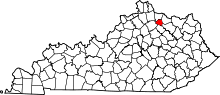 | |
| Unincorporated communities |
| |
| Footnotes | ‡This populated place also has portions in an adjacent county or counties | |
This article is issued from Wikipedia - version of the 7/27/2016. The text is available under the Creative Commons Attribution/Share Alike but additional terms may apply for the media files.