Phillips, Wisconsin
| Phillips, Wisconsin | |
|---|---|
| City | |
 | |
 Location of Phillips, Wisconsin | |
| Coordinates: 45°41′30″N 90°24′7″W / 45.69167°N 90.40194°WCoordinates: 45°41′30″N 90°24′7″W / 45.69167°N 90.40194°W | |
| Country | United States |
| State | Wisconsin |
| County | Price |
| Area[1] | |
| • Total | 3.51 sq mi (9.09 km2) |
| • Land | 2.79 sq mi (7.23 km2) |
| • Water | 0.72 sq mi (1.86 km2) |
| Elevation[2] | 1,444 ft (440 m) |
| Population (2010)[3] | |
| • Total | 1,478 |
| • Estimate (2012[4]) | 1,437 |
| • Density | 529.7/sq mi (204.5/km2) |
| Time zone | Central (CST) (UTC-6) |
| • Summer (DST) | CDT (UTC-5) |
| Zip Code | 54555 |
| Area code(s) | 715 & 534 |
| FIPS code | 55-62450[5] |
| GNIS feature ID | 1571294[2] |
| Website |
cityofphillips |
Phillips is a city in Price County, Wisconsin, United States. The population was 1,478 at the 2010 census. It is the county seat of Price County.[6]
History
The town of Phillips was platted in 1876 and named after Elijah B. Phillips, the general manager of the Wisconsin Central Railway. It began as a logging town.[7]
In the dry summer of 1894, a devastating fire spread from the southwest and destroyed the town. The population evacuated, and 13 people were killed in the blaze.[8][9] The town was rebuilt and expanded in subsequent years, and a memorial to the disaster now stands on the shore of Lake Duroy.[10]
Geography
Phillips is located at 45°41′30″N 90°24′7″W / 45.69167°N 90.40194°W (45.691560, -90.401915).[11] It is on highway SR 13, 77 miles north of Marshfield, and 74 miles south of Ashland.
According to the United States Census Bureau, the city has a total area of 3.51 square miles (9.09 km2), of which, 2.79 square miles (7.23 km2) is land and 0.72 square miles (1.86 km2) is water.[1]
Demographics
| Historical population | |||
|---|---|---|---|
| Census | Pop. | %± | |
| 1900 | 1,820 | — | |
| 1910 | 1,948 | 7.0% | |
| 1920 | 1,973 | 1.3% | |
| 1930 | 1,901 | −3.6% | |
| 1940 | 1,915 | 0.7% | |
| 1950 | 1,775 | −7.3% | |
| 1960 | 1,524 | −14.1% | |
| 1970 | 1,511 | −0.9% | |
| 1980 | 1,522 | 0.7% | |
| 1990 | 1,592 | 4.6% | |
| 2000 | 1,675 | 5.2% | |
| 2010 | 1,478 | −11.8% | |
| Est. 2015 | 1,388 | [12] | −6.1% |
2010 census
As of the census[3] of 2010, there were 1,478 people, 695 households, and 338 families residing in the city. The population density was 529.7 inhabitants per square mile (204.5/km2). There were 868 housing units at an average density of 311.1 per square mile (120.1/km2). The racial makeup of the city was 95.1% White, 0.7% African American, 0.7% Native American, 1.4% Asian, 0.1% Pacific Islander, 0.1% from other races, and 2.0% from two or more races. Hispanic or Latino of any race were 1.5% of the population.
There were 695 households of which 23.9% had children under the age of 18 living with them, 34.0% were married couples living together, 11.4% had a female householder with no husband present, 3.3% had a male householder with no wife present, and 51.4% were non-families. 45.0% of all households were made up of individuals and 24.3% had someone living alone who was 65 years of age or older. The average household size was 2.00 and the average family size was 2.79.
The median age in the city was 44.8 years. 20.2% of residents were under the age of 18; 7.4% were between the ages of 18 and 24; 22.9% were from 25 to 44; 25.9% were from 45 to 64; and 23.6% were 65 years of age or older. The gender makeup of the city was 47.6% male and 52.4% female.
2000 census
As of the census[5] of 2000, there were 1,675 people, 721 households, and 395 families residing in the city. The population density was 605.5 people per square mile (233.5/km²). There were 839 housing units at an average density of 303.3 per square mile (116.9/km²). The racial makeup of the city was 96.96% White, 1.19% Native American, 0.72% Asian, 0.12% from other races, and 1.01% from two or more races. Hispanic or Latino of any race were 0.36% of the population.
There were 721 households out of which 28.3% had children under the age of 18 living with them, 39.8% were married couples living together, 11.4% had a female householder with no husband present, and 45.1% were non-families. 39.8% of all households were made up of individuals and 21.9% had someone living alone who was 65 years of age or older. The average household size was 2.14 and the average family size was 2.89.
In the city the population was spread out with 22.7% under the age of 18, 7.3% from 18 to 24, 24.1% from 25 to 44, 21.7% from 45 to 64, and 24.1% who were 65 years of age or older. The median age was 42 years. For every 100 females there were 83.9 males. For every 100 females age 18 and over, there were 80.0 males.
The median income for a household in the city was $31,471, and the median income for a family was $38,889. Males had a median income of $32,333 versus $24,028 for females. The per capita income for the city was $16,480. About 7.2% of families and 12.5% of the population were below the poverty line, including 15.4% of those under age 18 and 21.4% of those age 65 or over.
Transportation
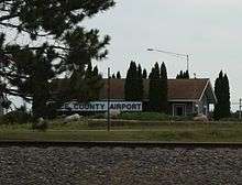
Phillips is served by the Price County Airport (KPBH), located one mile northwest of the city. In 2014, the airport handled approximately 18,100 operations per year, almost 50 per day, with roughly 84% general aviation, 15% air taxi and 1% military. The airport has a 5,000 foot asphalt runway with approved GPS approaches (Runway 1-19) and a 3,951 foot asphalt crosswind runway (Runway 6-24), also with GPS approaches. [14]
Notable people
- Adolph Bieberstein, NFL player
- Frank Boyle. Wisconsin State Assemblyman
- Esther Bubley, photographer
- Clayton Hicks, Wisconsin State Senator
- Willis J. Hutnik, Wisconsin State Assemblyman
- Felix A. Kremer, Wisconsin State Assemblyman
- Nathan E. Lane, Wisconsin State Assemblyman
- Chuck Mencel, NBA player
- Vincent J. Zellinger, Wisconsin State Assemblyman
- Fred Smith (1886-1976), an artist and sculptor whose works are preserved in the Wisconsin Concrete Park in Phillips.
Historic locations
Images
 Sign on WIS13
 Welcome sign
 Downtown Phillips on WIS 13
References
- 1 2 "US Gazetteer files 2010". United States Census Bureau. Retrieved 2012-11-18.
- 1 2 "US Board on Geographic Names". United States Geological Survey. 2007-10-25. Retrieved 2008-01-31.
- 1 2 "American FactFinder". United States Census Bureau. Retrieved 2012-11-18.
- ↑ "Population Estimates". United States Census Bureau. Retrieved 2013-06-24.
- 1 2 "American FactFinder". United States Census Bureau. Retrieved 2008-01-31.
- ↑ "Find a County". National Association of Counties. Retrieved 2011-06-07.
- ↑ Robert C. Ostergren and Thomas R. Vale. Wisconsin Land and Life. Madison: University of Wisconsin Press, 1997, p. 223.
- ↑ "Bio: Kliss, Frank & Mary (Phillips Fire - 27 Jul 1894)". Retrieved 2015-11-30.
- ↑ "Wisconsin Villages Burned". The New York Times. July 29, 1894. Retrieved 2015-11-30.
- ↑ Phillips Fire Centennial Book Committee, Phillips Fire Centennial, 1894-1994, Phillips, Wisconsin
- ↑ "US Gazetteer files: 2010, 2000, and 1990". United States Census Bureau. 2011-02-12. Retrieved 2011-04-23.
- ↑ "Annual Estimates of the Resident Population for Incorporated Places: April 1, 2010 to July 1, 2015". Retrieved July 2, 2016.
- ↑ "Census of Population and Housing". Census.gov. Retrieved June 4, 2015.
- ↑ http://www.airnav.com/airports/pbh
External links
| Wikimedia Commons has media related to Phillips, Wisconsin. |
- City of Phillips
- Phillips Area Chamber of Commerce
- Sanborn fire insurance maps: 1892 1893 1895 1901 1909
Municipalities and communities of Price County, Wisconsin, United States | ||
|---|---|---|
| Cities | 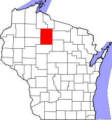 | |
| Villages | ||
| Towns | ||
| CDP | ||
| Unincorporated communities | ||
| Ghost towns | ||
| Footnotes | ‡This populated place also has portions in an adjacent county or counties | |