Peterson, Iowa
| Peterson, Iowa | |
|---|---|
| City | |
 | |
 Location of Peterson, Iowa | |
| Coordinates: 42°55′7″N 95°20′29″W / 42.91861°N 95.34139°WCoordinates: 42°55′7″N 95°20′29″W / 42.91861°N 95.34139°W | |
| Country |
|
| State |
|
| County | Clay |
| Area[1] | |
| • Total | 0.31 sq mi (0.80 km2) |
| • Land | 0.31 sq mi (0.80 km2) |
| • Water | 0 sq mi (0 km2) |
| Elevation | 1,250 ft (381 m) |
| Population (2010)[2] | |
| • Total | 334 |
| • Estimate (2012[3]) | 330 |
| • Density | 1,077.4/sq mi (416.0/km2) |
| Time zone | Central (CST) (UTC-6) |
| • Summer (DST) | CDT (UTC-5) |
| ZIP code | 51047 |
| Area code(s) | 712 |
| FIPS code | 19-62625 |
| GNIS feature ID | 0460102 |
Peterson is a city in Clay County, Iowa, United States. The population was 334 in the 2010 census, a decline from 372 in the 2000 census.[4][5]
History
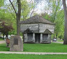
The first settlement was made at Peterson in 1856.[6] In 1862 a fort was built in Peterson by settlers to defend against anticipated Dakota attacks during the Dakota War of 1862. The fort was never attacked. The blockhouse from this fort still stands near its original location at the corner of Second and Park.
Peterson was platted in 1881 when the railroad was extended to that point.[7] The city was named for Adlie Peterson, an early settler.[8]
Geography
Peterson's longitude and latitude coordinates
in decimal form are 42.918490, -95.341502.[9]
It is situated near the Little Sioux River.
According to the United States Census Bureau, the city has a total area of 0.31 square miles (0.80 km2), all of it land.[1]
Demographics
| Historical population | |||
|---|---|---|---|
| Census | Pop. | %± | |
| 1870 | 44 | — | |
| 1890 | 371 | — | |
| 1900 | 521 | 40.4% | |
| 1910 | 480 | −7.9% | |
| 1920 | 580 | 20.8% | |
| 1930 | 598 | 3.1% | |
| 1940 | 603 | 0.8% | |
| 1950 | 589 | −2.3% | |
| 1960 | 565 | −4.1% | |
| 1970 | 469 | −17.0% | |
| 1980 | 470 | 0.2% | |
| 1990 | 390 | −17.0% | |
| 2000 | 372 | −4.6% | |
| 2010 | 334 | −10.2% | |
| Est. 2015 | 318 | [10] | −4.8% |
2010 census
As of the census[2] of 2010, there were 334 people, 156 households, and 95 families residing in the city. The population density was 1,077.4 inhabitants per square mile (416.0/km2). There were 196 housing units at an average density of 632.3 per square mile (244.1/km2). The racial makeup of the city was 99.4% White and 0.6% from two or more races. Hispanic or Latino of any race were 2.1% of the population.
There were 156 households of which 24.4% had children under the age of 18 living with them, 48.1% were married couples living together, 7.7% had a female householder with no husband present, 5.1% had a male householder with no wife present, and 39.1% were non-families. 37.2% of all households were made up of individuals and 25% had someone living alone who was 65 years of age or older. The average household size was 2.14 and the average family size was 2.78.
The median age in the city was 50.5 years. 19.5% of residents were under the age of 18; 4.8% were between the ages of 18 and 24; 18.6% were from 25 to 44; 30.9% were from 45 to 64; and 26.3% were 65 years of age or older. The gender makeup of the city was 47.9% male and 52.1% female.
2000 census
As of the census[12] of 2000, there were 372 people, 181 households, and 106 families residing in the city. The population density was 1,208.6 people per square mile (463.3/km²). There were 200 housing units at an average density of 649.8 per square mile (249.1/km²). The racial makeup of the city was 100.00% White. Hispanic or Latino of any race were 1.08% of the population.
There were 181 households out of which 22.1% had children under the age of 18 living with them, 52.5% were married couples living together, 5.0% had a female householder with no husband present, and 40.9% were non-families. 37.6% of all households were made up of individuals and 25.4% had someone living alone who was 65 years of age or older. The average household size was 2.06 and the average family size was 2.68.
In the city the population was spread out with 19.1% under the age of 18, 6.5% from 18 to 24, 21.2% from 25 to 44, 22.3% from 45 to 64, and 30.9% who were 65 years of age or older. The median age was 46 years. For every 100 females there were 96.8 males. For every 100 females age 18 and over, there were 92.9 males.
The median income for a household in the city was $30,000, and the median income for a family was $35,577. Males had a median income of $28,500 versus $20,179 for females. The per capita income for the city was $16,932. About 2.9% of families and 10.3% of the population were below the poverty line, including 7.7% of those under age 18 and 6.0% of those age 65 or over.
Media
The Peterson Patriot has been in print since 1880.
References
- 1 2 "US Gazetteer files 2010". United States Census Bureau. Retrieved 2012-05-11.
- 1 2 "American FactFinder". United States Census Bureau. Retrieved 2012-05-11.
- ↑ "Population Estimates". United States Census Bureau. Retrieved 2013-05-23.
- ↑ "Population & Housing Occupancy Status 2010". United States Census Bureau American FactFinder. Retrieved 2011-06-21.
- ↑ "Data from the 2010 Census". State Data Center of Iowa. Retrieved 2011-06-19.
- ↑ Gillespie, Samuel (1909). History of Clay County, Iowa: From Its Earliest Settlement to 1909. S. J. Clarke Publishing Company. p. 147.
- ↑ Gillespie, Samuel; Steele, James E. (1909). History of Clay County, Iowa: From Its Earliest Settlement to 1909. S.J. Clarke Publishing Company. p. 151.
- ↑ Chicago and North Western Railway Company (1908). A History of the Origin of the Place Names Connected with the Chicago & North Western and Chicago, St. Paul, Minneapolis & Omaha Railways. p. 113.
- ↑ "US Gazetteer files: 2010, 2000, and 1990". United States Census Bureau. 2011-02-12. Retrieved 2011-04-23.
- ↑ "Annual Estimates of the Resident Population for Incorporated Places: April 1, 2010 to July 1, 2015". Retrieved July 2, 2016.
- ↑ "Census of Population and Housing". Census.gov. Retrieved June 4, 2015.
- ↑ "American FactFinder". United States Census Bureau. Retrieved 2008-01-31.
External links
| Wikimedia Commons has media related to Peterson, Iowa. |
- City-Data Comprehensive statistical data and more about Peterson
Municipalities and communities of Clay County, Iowa, United States | ||
|---|---|---|
| Cities | ||
| Townships | ||