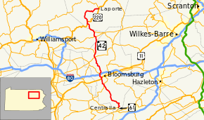
Pennsylvania Route 42
| ||||
|---|---|---|---|---|
 | ||||
| Route information | ||||
| Maintained by PennDOT | ||||
| Length: | 58.6 mi[1] (94.3 km) | |||
| Existed: | 1928 – present | |||
| Major junctions | ||||
| South end: |
| |||
|
| ||||
| North end: |
| |||
| Location | ||||
| Counties: | Columbia, Lycoming, Sullivan | |||
| Highway system | ||||
| ||||

Pennsylvania Route 42 (PA 42) is a 58.6-mile-long (94.3 km) state route located in central Pennsylvania. The southern terminus of the route is at Pennsylvania Route 61 in Centralia. The northern terminus is at U.S. Route 220 in Laporte. In Beech Glen, Sullivan County, it concurs with U.S. 220, loops through Eagles Mere and meets U.S. 220 farther north in Laporte at its northern terminus.
Until 1999, Pennsylvania Route 54 was also present at the southern terminus of PA 42.
Route description
Columbia County


PA 42 begins at an intersection with PA 61 in the near ghost town of Centralia in Columbia County, which has been largely abandoned because of a mine fire. From PA 61, the route heads north on two-lane undivided Locust Avenue. The road passes through abandoned areas of the town which have been overgrown with trees. The route turns east and crosses into Conyngham Township, becoming South Main Street and heading into forested areas. PA 42 becomes a four-lane road and heads to the northwest, passing through the residential community of Aristes, where it narrows back to two lanes. The road curves to the northeast and becomes Numidia Drive, heading into the Weiser State Forest and turning to the northwest as it crosses Big Mountain. The route turns west and northwest through more dense forests, passing to the east of Shamokin Reservoir. Continuing to the west-northwest, PA 42 enters Locust Township as it crosses Little Mountain, leaving the state forest and turning to the north. The road heads into open agricultural areas with some woods and residences. The route briefly turns northwest before heading north again and passing through the community of Numidia. PA 42 curves to the northwest as it heads through more rural areas, crossing the Roaring Creek and continuing into Catawissa Township. The road runs through a mix of farmland and woodland with some homes, gaining a second northbound lane. The route becomes a four-lane road in a wooded area before turning into a three-lane road with one northbound lane and two southbound lanes. PA 42 comes to an intersection with PA 487, at which point that route joins PA 42 for a concurrency, with the two routes heading north through more woodland as a two-lane road. The road crosses the Catawissa Creek into Catawissa and becomes Mill Street, heading northwest into residential areas. PA 42 splits from PA 487 by heading west-northwest on Main Street, heading through the commercial downtown of Catawissa. The road crosses Norfolk Southern's Sunbury Line before heading across the Susquehanna River, at which point the road becomes Rupert Drive and heads into Montour Township. Here, the route turns north and crosses the North Shore Railroad. PA 42 runs through wooded areas immediately to the west of the railroad tracks with the Susquehanna River a short distance to the east. The road turns north-northwest away from the railroad tracks and heads through the residential community of Rupert. The route passes through more woodland with some homes before reaching an interchange with US 11.[1][2]
At this point, PA 42 heads northeast concurrent with US 11 on four-lane divided Montour Boulevard, crossing the Fishing Creek into Bloomsburg. Immediately after, the route splits from US 11 at another interchange, heading northwest on four-lane divided Mall Boulevard and crossing the Fishing Creek back into Montour Township. The road heads near residential areas and narrows into a two-lane undivided road, crossing a stream into Hemlock Township. PA 42 heads through wooded areas with some nearby commercial development, turning to the north and passing near some farmland, widening back into a four-lane divided highway. The road enters commercial areas and comes to an interchange with I-80, intersecting the southern terminus of PA 44 at the north end of the interchange. The route passes more businesses, heading to the west of the Columbia Mall. PA 42 narrows into a two-lane undivided road and heads northeast through agricultural areas. The route turns north onto Millville Road and runs through wooded areas to the west of Little Fishing Creek. The road curves to the north-northwest and heads through more woodland with some farm fields and homes, continuing to the west of the creek. PA 42 heads back to the north and continues through more rural areas, crossing into Madison Township and turning to the west, becoming an unnamed road. The road turns back to the north and heads through farmland with some homes, crossing the Little Fishing Creek into Mount Pleasant Township. The route curves to the northwest and runs through more wooded areas with some farms and residences to the northeast of the creek, entering Greenwood Township and turning to the north, passing through the residential community of Eyers Grove. PA 42 continues through agricultural areas with some woods and homes, turning north-northwest and crossing into Millville. The road passes through more rural areas before becoming South State Street and running past homes. In the center of town, the route intersects PA 254 and becomes North State Street, heading through more residential areas. PA 42 passes a few businesses before turning north and heading back into Greenwood Township. Here, the road again runs along the east bank of the Little Fishing Creek as it becomes an unnamed and heads through rural areas of residential and commercial development, passing through Iola. The route heads north-northeast into a mix of farmland and woodland with some homes and intersects the eastern terminus of PA 442. PA 42 crosses the creek into Pine Township and heads north through Sereno, running through more farms and woods with occasional residences before heading into more forested areas. Farther north, the road passes through a mix of farmland and woodland with a few homes.[1][2]


Lycoming County
PA 42 enters Jordan Township in Lycoming County and continues through more agricultural and wooded areas with some residences. The road heads into more forested areas with a few homes, turning northwest and intersecting PA 118. The route curves back to the north and runs through more woodland with some farm fields and homes. PA 42 continues through agricultural areas and heads into Franklin Township, turning to the northwest and passing through more farmland and woodland with a few residences. The road heads through woods as it comes to a junction with the northern terminus of PA 239. The route continues west-northwest through more farms and woods with homes, passing through North Mountain. The road turns more to the northwest and briefly passes through a corner of Penn Township.[1][3]
Sullivan County
PA 42 heads into Davidson Township in Sullivan County, turning to the north and passing through wooded areas with some fields and homes. The road curves to the northwest as it heads through forests, turning to the west and coming to an intersection with US 220 in Beech Glen. At this point, the route turns north to form a concurrency with US 220 on the Appalachian Throughway, heading through a mix of farmland and woodland with a few residences. The road crosses the Muncy Creek and PA 42 splits from US 220 in Muncy Valley by heading northwest on an unnamed road. The route heads north through forested areas, crossing the Trout Run into Shrewsbury Township. The road heads northwest before turning to the north, continuing through dense forests. PA 42 heads through wooded areas with a few homes, curving more to the northeast and becoming Eagles Mere Avenue. The road turns to the east and enters Eagles Mere, passing through residential areas to the south of Eagles Mere Lake. The route heads back into Shrewsbury Township and becomes unnamed again, winding east through more dense forests. PA 42 heads into Laporte Township and turns to the northeast, passing to the west of Celestial Lake. The road turns to the east and continues through forested areas with some homes, heading into Laporte. Here, PA 42 becomes Main Street and passes homes with a few businesses before ending at another intersection with US 220.[1][4]
Major intersections
| County | Location | mi | km | Destinations | Notes |
|---|---|---|---|---|---|
| Columbia | Centralia | 0.0 | 0.0 | Southern terminus | |
| Catawissa | 13.7 | 22.0 | South end of PA 487 concurrency | ||
| 14.4 | 23.2 | North end of PA 487 concurrency | |||
| Bloomsburg | 17.5 | 28.2 | Interchange, south end of US 11 concurrency | ||
| 18.0 | 29.0 | Interchange, north end of US 11 concurrency | |||
| Hemlock Township | 19.8 | 31.9 | Interchange | ||
| 20.0 | 32.2 | Southern terminus of PA 44 | |||
| Millville | 28.6 | 46.0 | |||
| Greenwood Township | 30.1 | 48.4 | Eastern terminus of PA 442 | ||
| Lycoming | Jordan Township | 38.1 | 61.3 | ||
| Franklin Township | 41.2 | 66.3 | Northern terminus of PA 239 | ||
| Sullivan | Davidson Township | 45.7 | 73.5 | South end of US 220 concurrency | |
| Davidson Township | 46.7 | 75.2 | North end of US 220 concurrency | ||
| Laporte | 58.6 | 94.3 | Northern terminus | ||
1.000 mi = 1.609 km; 1.000 km = 0.621 mi
| |||||
PA 42 Truck
| |
|---|---|
| Location: | Sullivan County, Pennsylvania |
| Existed: | 1980–present |
Pennsylvania Route 42 Truck is a 9-mile-long (14 km) truck route in Sullivan County, Pennsylvania. While the final miles of Route 42 wind through state forest land toward Laporte, trucks are designated to follow the much simpiler alignment of U.S. Route 220, with which Truck 42 is cosigned for its entire length. The truck route also uniquely terminates at the same intersection as its parent route.
See also
 U.S. Roads portal
 Pennsylvania portal
References
| Wikimedia Commons has media related to Pennsylvania Route 42. |
- 1 2 3 4 5 Google (December 22, 2011). "overview of Pennsylvania Route 42" (Map). Google Maps. Google. Retrieved December 22, 2011.
- 1 2 Columbia County, Pennsylvania Highway Map (PDF) (Map). PennDOT. 2011. Retrieved December 13, 2011.
- ↑ Lycoming County, Pennsylvania Highway Map (PDF) (Map). PennDOT. 2011. Retrieved July 11, 2011.
- ↑ Sullivan County, Pennsylvania Highway Map (PDF) (Map). PennDOT. 2011. Retrieved December 16, 2011.