Pennsylvania Route 254
| ||||
|---|---|---|---|---|
 | ||||
| Route information | ||||
| Maintained by PennDOT | ||||
| Length: | 30.1 mi[1] (48.4 km) | |||
| Major junctions | ||||
| West end: |
| |||
|
| ||||
| East end: |
| |||
| Location | ||||
| Counties: | Northumberland, Montour, Columbia | |||
| Highway system | ||||
| ||||

Pennsylvania Route 254 (PA 254) is a 30-mile-long (48 km) state highway located in Northumberland, Montour, and Columbia Counties in Pennsylvania. The western terminus is at PA 405 in Milton. The eastern terminus is at PA 487 near Benton.
Route description
Northumberland and Montour counties


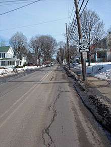
PA 254 begins at an intersection with PA 405 in Milton, Northumberland County, heading east on two-lane undivided Broadway Street. The road passes through the commercial downtown, crossing a Norfolk Southern railroad line and heading into residential areas. The road heads into Turbot Township and becomes Broadway, reaching an interchange with the PA 147 freeway. Past this, PA 254 becomes an unnamed road and runs through agricultural areas with some woods and homes. The road comes to an interchange with I-80, at which point it is a four-lane divided highway, before turning back into a two-lane undivided road and heading northeast through open farmland with occasional residences. The route heads east-northeast into Limestone Township in Montour County and becomes Broadway, running through more rural areas. PA 254 enters Derry Township and becomes Washingtonville Road, crossing the Chillisquaque Creek before coming to an intersection with PA 54 to the south of Washingtonville. The road heads northeast through more farmland with some woods and homes, turning to the east.[1][2]
Columbia County
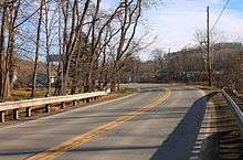
PA 254 enters Madison Township in Columbia County, running northeast through more rural areas and coming to an intersection with PA 44 and the eastern terminus of PA 642 in the community of Jerseytown. The road becomes Jerseytown Road and continues through more farmland and woodland with occasional residences, becoming Rohrsburg Road. The route crosses the Little Fishing Creek into Millville and becomes West Main Street, passing residential and commercial areas as it intersects PA 42. Following this intersection, PA 254 becomes East Main Street and heads past homes before turning east and crossing into Greenwood Township, where it becomes Rohrsburg Road again. The road heads through open agricultural areas with some woods and residences, reaching the residential community of Rohrsburg. Here, the route turns sharply north to continue along Rohrsburg Road and passes through more farmland before turning northeast into a mix of farmland and woodland, passing through a corner of Fishing Creek Township before heading into Benton Township. PA 254 curves to the east and crosses Fishing Creek prior to ending at an intersection with PA 487.[1][3]
Major intersections
| County | Location | mi | km | Destinations | Notes |
|---|---|---|---|---|---|
| Northumberland | Milton | Western terminus of PA 254 | |||
| Interchange | |||||
| Interchange | |||||
| Montour | Washingtonville | ||||
| Columbia | Madison Township | Eastern terminus of PA 642 | |||
| Millville | |||||
| Benton | Eastern terminus of PA 254 | ||||
| 1.000 mi = 1.609 km; 1.000 km = 0.621 mi | |||||
See also
 U.S. Roads portal
 Pennsylvania portal
References
- 1 2 3 Google (December 16, 2011). "overview of Pennsylvania Route 254" (Map). Google Maps. Google. Retrieved December 16, 2011.
- ↑ Montour County and Northumberland County, Pennsylvania Highway Map (PDF) (Map). PennDOT. 2011. Retrieved March 4, 2011.
- ↑ Columbia County, Pennsylvania Highway Map (PDF) (Map). PennDOT. 2011. Retrieved December 13, 2011.
External links
| Wikimedia Commons has media related to Pennsylvania Route 254. |