Pavonia Terminal
Jersey City | |||||||||||||||||||||||||||||||||||||||
|---|---|---|---|---|---|---|---|---|---|---|---|---|---|---|---|---|---|---|---|---|---|---|---|---|---|---|---|---|---|---|---|---|---|---|---|---|---|---|---|
 | |||||||||||||||||||||||||||||||||||||||
| Location | Harsimus Cove, Jersey City, New Jersey | ||||||||||||||||||||||||||||||||||||||
| Owned by | Erie Railroad | ||||||||||||||||||||||||||||||||||||||
| Line(s) |
Erie Railroad Main Line New York, Susquehanna and Western Railroad Bergen County Railroad New York and Greenwood Lake Railroad New Jersey and New York Railroad Weehawken Branch Newark Branch Northern Branch | ||||||||||||||||||||||||||||||||||||||
| Construction | |||||||||||||||||||||||||||||||||||||||
| Platform levels | 1 | ||||||||||||||||||||||||||||||||||||||
| Other information | |||||||||||||||||||||||||||||||||||||||
| Station code | 4971[1] | ||||||||||||||||||||||||||||||||||||||
| History | |||||||||||||||||||||||||||||||||||||||
| Opened | 1887 | ||||||||||||||||||||||||||||||||||||||
| Closed | 1958 | ||||||||||||||||||||||||||||||||||||||
| Electrified | Not electrified | ||||||||||||||||||||||||||||||||||||||
| Services | |||||||||||||||||||||||||||||||||||||||
| |||||||||||||||||||||||||||||||||||||||
| Location | |||||||||||||||||||||||||||||||||||||||
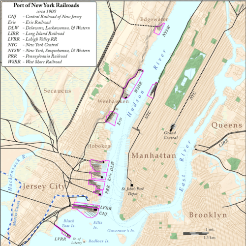 Jersey City Location on a map showing the railroads in the New York City area ca 1900 | |||||||||||||||||||||||||||||||||||||||
Pavonia Terminal was the Erie Railroad terminal on the Hudson River situated on the landfilled Harsimus Cove in Jersey City, New Jersey. The station opened in 1887 and closed in 1958 when the Erie railroad moved its passenger services to nearby Hoboken Terminal. The New York, Susquehanna and Western Railway also ran commuter trains from the terminal and various street cars, ferries and the Hudson and Manhattan Railroad subway line serviced the station.
History
Pavonia was one of five passenger railroad terminals that lined the western shore of the Hudson Waterfront from the mid-19th to mid-20th centuries, along with those at Weehawken, Hoboken, Exchange Place, and Communipaw.
The Erie began developing the waterfront site in 1856.[2] The intermodal complex was open December 4, 1887[3] Across the river-facing facade was New York, Lake Erie and Western Railroad, the name of the entity that built it, though it was also called Jersey City Terminal Station[4] or Erie Railroad Station The colloquial name is taken from the 17th century European settlement of Pavonia, New Netherland[5] which began in the area and the ferry that served it. It has been described as "a brightly colored Victorian eclectic three story terminal located at the foot of Pavonia Avenue to serve a twelve track" station. It was designed by George E. Archer.[6] The end of track was at about 40.7266 N 74.0304 W. Besides the railroad, the complex was served by ferries, streetcars and the rapid transit Hudson and Manhattan Railroad (now PATH). The terminal was also used by New York, Susquehanna and Western Railway trains.[7] Long distance and suburban passenger trains reached the terminal by travelling through Bergen Hill via the Long Dock Tunnel and later under the Bergen Arches.[8]
In October 1956 the Erie Railroad began moving its trains out of Pavonia Terminal and into Delaware, Lackawanna and Western Railroad's Hoboken Terminal, and by 1960 had merged to become the Erie Lackawanna Railway.[9] Erie's Northern Branch trains moved to Hoboken in 1959; the New York, Susquehanna and Western operated to the terminal until it pulled back to Susquehanna Transfer in 1961. The terminal was razed by 1961.[10]
Service
Railroads

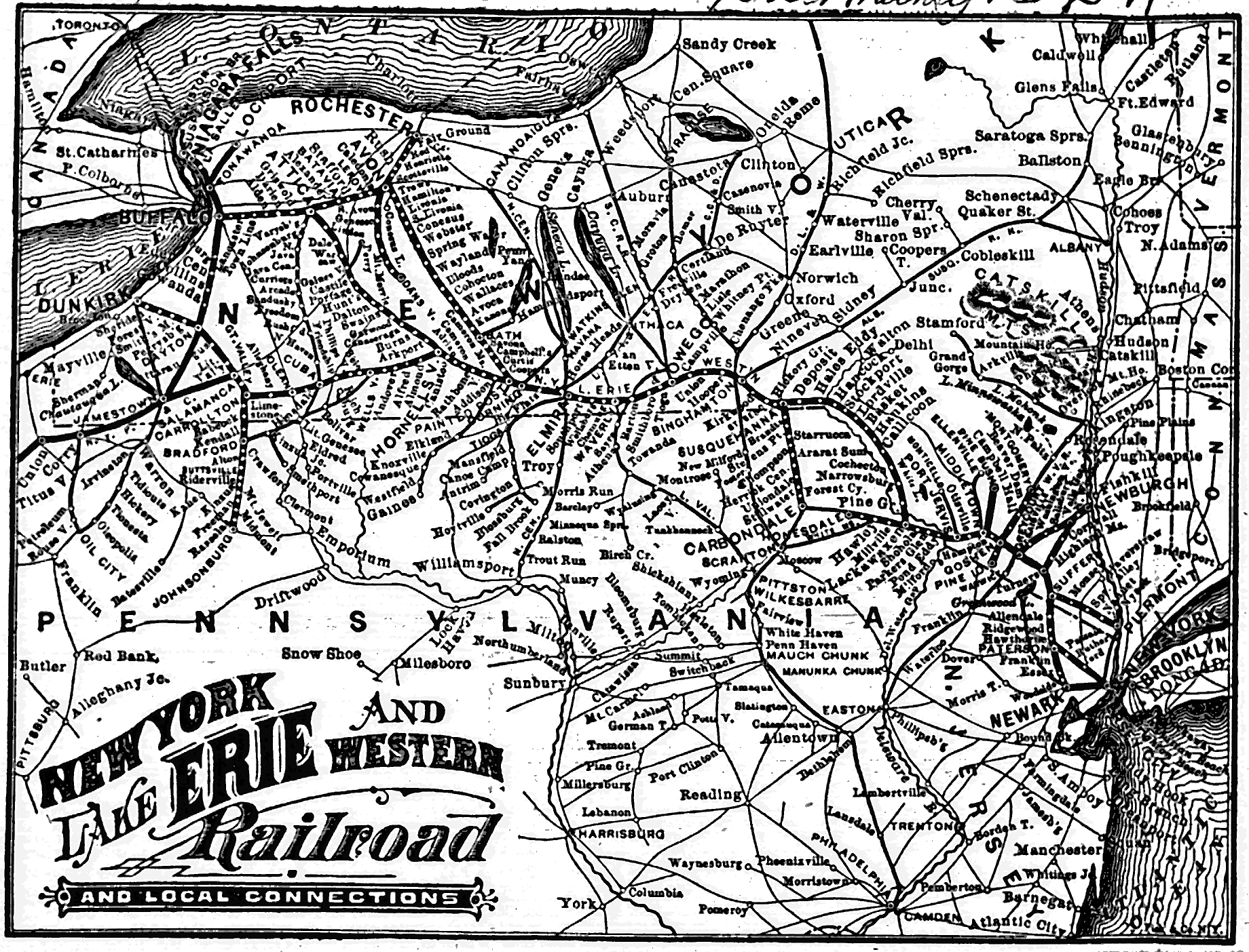
The Erie Railroad's Main Line ran from Jersey City to Chicago via Binghamton and Youngstown; with a line to Buffalo, and a line to Akron with a spur to Cleveland.[11] The name and a portion of the route exists in the form of the New Jersey Transit Main Line to Suffern, New York and, under contract for Metro North, all the way to Port Jervis. Parts of the contemporary Bergen County Line and Pascack Valley Line were also Erie operated, while sections of its Greenwood Lake Branch have been incorporated into the Montclair-Boonton Line. The Northern Branch of the Northern Railroad of New Jersey is another line from the Erie era along which freight is transported and that may be revived as light rail service.[12][13] The last train to leave the station, the #1205 at 6:35 p.m. on Friday, December 12, 1958 was along the Northern Branch. The Newark Branch (with continuing service to Paterson) and the Orange Branch were also parts of its suburban network. The New York, Susquehanna and Western Railway main line ran to Wilkes-Barre,[7] although passenger service was operated that far for only a few years (and that Wilkes Barre and Eastern line was completely abandoned, even for freight service, in 1939), while regular commuter service ran only to Butler, NJ until 1966.
The timetable for 17 August 1947 shows 96 weekday departures: 48 to the main line and Bergen County line (including 6 beyond Port Jervis), 6 to Spring Valley, 26 NY&GL, 5 Newark Branch, 3 to Nyack and 8 NYS&W.
Ferry

The Pavonia Ferry began running in 1851,[14] along a route that had been established some decades earlier as Budd's Ferry. It was taken over by the Erie[15] and sold to the Pavonia Ferry Company of Jersey City[16] for what was considered a low price of $9,050, at New York City Hall, in February 1854.[5][17] In February 1859 Nathaniel Marsh of the Erie Railroad Company purchased the lease on behalf of the Pavonia Ferry Company. He started a ferry which ran from Chambers Street (Manhattan) to the foot Pavonia Avenue on the other side of the Hudson River. Legal problems had prevented the Pavonia Ferry Company from establishing a ferry along this route. The New York and Erie Railroad paid an annual rent of $9,050 to transport passengers back and forth.[18] Eventually the railroad constructed its Pavonia Terminal on the land-filled Harsimus Cove. Suburban and long distance travelers would transfer from trains to boats for the passage across the river.
Its final two routes from the terminal across the Hudson to Lower Manhattan, one to 23rd Street and another to Chambers Street.
Many streetcar systems began at the Manhattan side of the many ferries that at landed there. The Metropolitan Street Railway system began after the merger of the Chambers Street & Grand Street (Manhattan) Ferry Railway and the Houston Street (Manhattan), West Street & Pavonia Ferry Railroad, on January 30, 1891. The roads were capitalized for $800,000 and $250,000 respectively, totaling a combined capital of $1,050,000.[19]
A January 18, 1903 letter from a Passaic, New Jersey reader to The New York Times, commented about the inadequacy of the boats of the Pavonia Ferry, which was then the property of the Erie Railroad. All their boats are old, small and entirely inadequate to accommodate the crowds during rush hours. The vessels then in use by the Erie Railroad, listed with first year of service, were Pavonia (1861), Susquehanna (1865), Delaware (1868), Chatauqua (1868), Passaic (1869), Ridgewood (1873), Paterson (1886), and J.G. McCullough (1891).[20]
New York Waterway re-introduced service to Pier 79 at West 39th Street on December 1, 2006.[21] Service officially ended January 2014.[22]
Streetcar
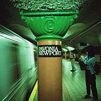
Numerous streetcar lines that served the station.[23] Eventually they (and indeed all of Hudson County lines) were operated by the Public Service Railway. The Grove Street, which operated between Exchange Place and Hudson Place (Hoboken), passed nearby. The Pavonia and the Crosstown originated at the station. The Hudson Bergen Light Rail Pavonia/Newport Station opened in 2002, and is located one and half blocks west of the PATH system.
H & M tube station
Originally named "Erie", the PATH's Newport station, originally built by the Hudson and Manhattan Railroad (H&M), still bears the letter "E" engraved on its pillars. Opened on August 2, 1909,[24] the station was built with only the island platform. The side platform was added around 1914 to handle the heavier passenger volume. It was closed in 1954 in order for the bankrupt railroad to reduce costs. The side platform remained dormant for nearly 50 years.[25] The northernmost stairway exit from the two platforms led to a steep passageway, which originally went directly to the Erie Railroad terminal. In the 1920s, a second passageway and mezzanine area was built over the existing platforms and northbound trackway. This second passageway and mezzanine area were also closed in 1954 (as was also the entrance to/from Henderson Street), but was reopened in the late 1980s/early 1990s after the station was renovated. Also in 1954, the first moving sidewalk, or travellator, in the United States was installed. Named the "Speedwalk" and built by Goodyear, it was 277 feet (84 m) long and moved up a 10-percent grade at a speed of 1.5 miles per hour (2.4 km/h).[26] The walkway was removed a few years later when traffic patterns at the station changed.
Site

The complex was built on the northern portion of landfilled Harsimus Cove. The southern part was the Pennsylvania Railroad abattoir and freight yard. A narrow slip kept that name, while another called the Long Slip was created and separated it from Hoboken Terminal. The only visible trace of the Erie's waterfront complex that remains today is part of the right of way/viaduct which carried trains from the foot of the Palisades escarpment to the waterfront. Part of it runs parallel to Boyle Plaza (the toll plaza for the Holland Tunnel) and is used for motor vehicular traffic to the Newport Section of the city.[27]
See also
- North River (Hudson River)
- Bergen Hill
- Timeline of Jersey City area railroads
- List of ferries across the Hudson River in New York City
- Railroad terminals in New York City
- Houston, West Street and Pavonia Ferry Railroad
- Pier 63
References
- ↑ "List of Station Names and Numbers". Jersey City, New Jersey: Erie Railroad. May 1, 1916. Retrieved November 23, 2010.
- ↑ "Erie Railroad Improvements". New York Times. 1856. Retrieved 2011-01-31.
- ↑ "A Handsome Building: The Erie Railway's New Station at Jersey City." New York Times 4 December 1887.
- ↑ Jersey City Terminal Station
- 1 2 "Erie Railroad Terminal". New Jersey City University. Retrieved 2010-05-30.
- ↑ "Jersey Central Railroad Jersey City Ferry Terminal Johnson Ave. at Hudson River Jersey City Hudson County New Jersey (HAER No. NJ-27)" (PDF). Historical American Engineering Record. p. 16. Retrieved 2013-05-05.
- 1 2 NYSW Stations
- ↑ "The Bergen Arches of the Erie Railroad". Jersey City Landmarks Conservancy. Retrieved 2010-05-30.
- ↑ "The Erie and the DL&W Were Merged in 1960". Retrieved 2010-05-30.
- ↑ "Erie Lackwanna Railroad and Predecessors". Retrieved 2010-05-30.
- ↑ http://upload.wikimedia.org/wikipedia/commons/e/e9/1884_Erie.gif
- ↑ Bogaty, Lewis (2009). "Northern Branch Photos & Information". Retrieved 2010-05-30.
- ↑ "Northern Branch Corridor Project". New Jersey Transit. Retrieved 2010-05-30.
- ↑ Baxter, Raymond J.; Adams, Arthur G. (1999). Railroad Ferries of the Hudson. New York: Fordham University Press. p. 65. ISBN 0-8232-1954-2.
- ↑ "Sale Postponed". The New York Times. February 2, 1854. p. 6. Retrieved 2010-05-30.
- ↑ "The Pavonia Ferry Lease Sold at Auction". The New York Times. February 16, 1854. p. 8. Retrieved 2010-05-30.
- ↑ "Corporation Doings". The New York Times. February 24, 1854. p. 4. Retrieved 2010-05-30.
- ↑ "Aldermen's Committee On Ferries". The New York Times. February 1, 1859. p. 5. Retrieved 2010-05-30.
- ↑ "Metropolitan's Capitalization". The Wall Street Journal. May 25, 1904. p. 1.
- ↑ "Pavonia Ferry Service". The New York Times. January 20, 1903. p. 8. Retrieved 2010-05-30.
- ↑ "Newport Ferry to Pier 79, West 39th Street, Manhattan". New York City Department of Transportation. Retrieved 2010-05-30.
- ↑ McDonald, Terrence (January 18, 2014). "NY Waterway officially ends service from Newport terminal". The Jersey Journal. Retrieved 2014-09-18.
- ↑ "New Erie Road Terminal". The New York Times. March 31, 1903. p. 7. Retrieved 2010-05-30.
- ↑ "Tube Stations". hudsoncity.net. Retrieved 2006-04-14.
- ↑ "PATH to Reopen Commuter Platform at Pavonia/Newport Station" (Press release). Port Authority of New York and New Jersey. August 11, 2003. Retrieved 2010-05-30.
- ↑ "Passenger Conveyor Belt to Be Installed in Erie Station". The New York Times. October 6, 1953. p. 31. Retrieved 2010-05-30.
- ↑ Erie ROW
External links
- New York Times 1873 Terminal fire
- New York Times 1903 terminal relocation
- New York times 1903 letter listing ferries
- Evolution of the New York Harbor ferries
- Overview of rail companies serving Hudson Waterfront
Coordinates: 40°43′36″N 74°02′05″W / 40.726676°N 74.034757°W
- Departure from terminal (video)
- New York, Lake Erie, and Western Jersey City Passenger Terminal 1886
- meeting to discuss better service 1879
- Paterson and Newark Railroad
- Breakwater and Pavonia collision
- photos of Hudson River ferries and terminals
- Map of Erie System 1884