Bergen Hill
Bergen Hill refers to the lower Hudson Palisades in New Jersey, United States, where they emerge on Bergen Neck,[1] which in turn is the peninsula between the Hackensack and Hudson River, and their bays. In Hudson County, it reaches a height of 260 feet.[2]
Rail


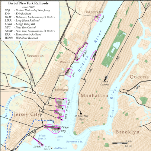
Defining features of Bergen Hill include the 19th century and early 20th century railroad right of ways. cuts and tunnels created to provide access to the terminals and ferries on the North River (Hudson River) and Upper New York Bay, and eventually under the river. From south to north they are:
- The Central Railroad of New Jersey lines traveled on the CRRNJ Newark Bay Bridge across Newark Bay and through Bayonne and Greenville to its Communipaw Terminal. Portions are used by the Hudson Bergen Light Rail.
- The Jersey City, Newark and Western Railway (later the Lehigh Valley Terminal Railway) freight line on the bridge over Newark Bay and across Pamrapo is now used by CSX Transportation as the National Docks Secondary to Port Jersey and other points.
- Newark and New York Railroad Branch of the Central Railroad of New Jersey (1869),[3] now the Hudson-Bergen Light Rail West Side Branch, ran from Downtown Newark to Communipaw Terminal.

- The Bergen Hill Cut (1838)- opened by, New Jersey Rail Road and Transportation Company, eventually to Pennsylvania Railroad to PRR Station at Exchange Place or Harsimus Branch along the Harsimus Stem Embankment to Harsimus Cove. Now used by PATH Journal Square and Newark lines
- The Erie Cut (1910), whose portals are known as the Bergen Arches-Erie Railroad to Pavonia Terminal, now unused[4]
- The Long Dock Tunnel (1860)- the first Erie Cut, now Conrail Shared Assets freight line[5][6]
- The Bergen Hill Tunnels (1876) & (1908) under Jersey City Heights, built by Morris and Essex Railroad and the Delaware, Lackawanna, and Western Railroad, Later, the Erie Lackawanna, and now, New Jersey Transit rail lines to Hoboken Terminal.[7][8][9][10]
- 9th Street-Congress Street (HBLR station) provides elevator service between the platform in Hoboken and Paterson Plank Road in Jersey City Heights
- THE Tunnel was a planned, but now canceled, new mass transit tunnel that would have connected Secaucus Junction with an expanded Pennsylvania Station
- The proposed Gateway Project would build a tunnel from North Bergen to Weehawken Cove and then under the Hudson
- The North River Tunnels (1910), part of the Northeast Corridor and Northeast Corridor Line, their western entrance called the Bergen Portal[11]
- Liberty Place in Weehawken, New Jersey was cut and tunnel for the rail line connecting the waterfront elevator to the entrance of 19th century Eldorado Park, later used by the North Hudson Railway streetcar lines.[12]
- Weehawken Tunnel, (1861) West Shore Railroad, now Hudson Bergen Light Rail[13][14][15]
- Edgewater Tunnel (1894)[16][17] New York, Susquehanna and Western Railway cut and tunnel the western portal in Fairview and Hudson River portal in Shadyside, Edgewater.[18][19]
Streetcars
The North Hudson County Railway or its predecessor was responsible for many of the innovative engineering works which made streetcar travel on the east face of Bergen Hill possible, including funicular wagon lifts, an inclined elevated, a luxurious elevator, Horseshoe curves, and viaducts.
Vehicular cuts
Other major excavations and structures for vehicular traffic have significantly altered Bergen Hill. Kennedy Boulevard at Journal Square and Journal Square Transportation Center both span the large ravine created there. The Divided Highway connecting the Pulaski Skyway to the Holland Tunnel runs parallel to the Long Dock Tunnel. The Lincoln Tunnel Approach and Helix connects the Lincoln Tunnel, which itself enters the Palisades before submerging under the Hudson River. Paterson Plank Road, the Wing Viaduct, Hackensack Plank Road, Pershing Road, Gorge Road are located on the face of the cliffs. Shippen Street in Weehawken is small street that makes a double hairpin turn.
Jersey City section
Bergen Hill, Jersey City has sometimes been called colloquially "The Hill",[20] and gives name to The Bergen Hill Historic District[21] Other prominent landmarks on the east side of the hill are the former Jersey City Medical Center (which since 2005 is being renovated and restored as an emerging neighborhood known as Beacon) and the Jersey City High School. Summit Avenue, which starts at The Junction in the Bergen-Lafayette Section follows the route of a path used by Native Americans from their settlement at Communipaw, and was used by New Netherlanders from that village on the bay to the one on the ridge at Bergen. It intersected Newark Plank Road, an early colonial "turnpike" which ran from Paulus Hook over the hill, at Five Corners, and continued north through Bergen Woods[22] where it connected with Paterson Plank Road and Hackensack Plank Road.
See also
- Newark Plank Road
- Timeline of Jersey City area railroads
- List of stations on the Central Railroad of New Jersey
- List of crossings of the Hackensack River
- List of bridges, tunnels, and cuts in Hudson County, New Jersey
References
- ↑ Bergen Hill
- ↑ "Hudson County High Point, New Jersey". Peakbagger.com.
- ↑ Mt Pleasant?
- ↑ http://www.njcu.edu/Programs/jchistory/Pages/B_Pages/Bergen_Arches.htm
- ↑ Stone above Long Dock Tunnel
- ↑ http://query.nytimes.com/mem/archive-free/pdf?res=F00A12FB395B137B93C0A8178ED85F438784F9
- ↑ French, Kenneth, Images of Rail: Railroads of Hoboken and Jersey City,Arcadia Publishing, 2002, p125, ISBN 978-0-7385-0966-2
- ↑ http://www.njtransit.com/tm/tm_servlet.srv?hdnPageAction=PressReleaseTo&PRESS_RELEASE_ID=203
- ↑ http://query.nytimes.com/mem/archive-free/pdf?res=F00A12FB395B137B93C0A8178ED85F438784F9
- ↑ http://bergenwaldo.blogspot.nl/p/erie-tunnel.html
- ↑ https://www.gutenberg.org/files/21083/21083-h/21083-h.htm
- ↑ http://query.nytimes.com/mem/archive-free/pdf?res=F30610F7355515738DDDAE0994DF405B8285F0D3
- ↑ [pubsindex.trb.org/view.aspx?id=700173 - 54k Weehawken Tunnel]
- ↑ http://www.mindat.org/loc-12816.html Weehawken Bergen tunnel
- ↑ at western portal
- ↑ Palisades Tunnel completed
- ↑ http://query.nytimes.com/mem/archive-free/pdf?_r=1&res=9B0DE4DA1F3FEF33A25754C1A9659C94629ED7CF Palisades/NYS&W Tunnel
- ↑ Palisades Tunnel
- ↑ Palisades diabase
- ↑ Bergen Hill
- ↑ Bergen Hill Historic District map
- ↑ Van Vorst Farmhouse in Bergen Woods
| Bridges of the Newark Bay | ||||
|---|---|---|---|---|
| ||||
| Bergen-Lafayette |  | |
|---|---|---|
| Downtown | ||
| Greenville | ||
| The Heights | ||
| Journal Square | ||
| Meadowlands | ||
| Upper New York Bay | ||
| West Side | ||
| Historical | ||
Coordinates: 40°43′03″N 74°04′14″W / 40.717363°N 74.070515°W