Paulpietersburg
| Paulpietersburg | |
|---|---|
|
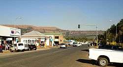
View up Hoog Street with Dumbe hill in background | |
 Paulpietersburg  Paulpietersburg  Paulpietersburg
| |
| Coordinates: 27°25′S 30°49′E / 27.417°S 30.817°ECoordinates: 27°25′S 30°49′E / 27.417°S 30.817°E | |
| Country | South Africa |
| Province | KwaZulu-Natal |
| District | Zululand |
| Municipality | eDumbe |
| Established | 1888[1] |
| Government | |
| • Councillor | BM Nxusa (NFP) |
| Area[2] | |
| • Total | 36.56 km2 (14.12 sq mi) |
| Population (2011)[2] | |
| • Total | 1,859 |
| • Density | 51/km2 (130/sq mi) |
| Racial makeup (2011)[2] | |
| • Black African | 56.7% |
| • Coloured | 1.0% |
| • Indian/Asian | 1.5% |
| • White | 37.3% |
| • Other | 3.6% |
| First languages (2011)[2] | |
| • Zulu | 48.8% |
| • Afrikaans | 23.1% |
| • English | 11.5% |
| • Other | 16.6% |
| Postal code (street) | 3180 |
| PO box | 3180 |
| Area code | 034 |
Paulpietersburg is a small town in KwaZulu-Natal, South Africa. It was established in 1888 and was then part of the Transvaal Republic. It was named after then President Paul Kruger and Voortrekker hero Piet Joubert.
Town 72 km south of Piet Retief and 151 km north-east of Dundee. It was established in 1888, proclaimed a township in 1910, and attained municipal status in 1958. Named after President Paul Kruger and General Piet Joubert, it was first called Paulpietersrust, then Paulpietersdorp, and Paulpietersburg in 1896.[3]
References
- ↑ "Chronological order of town establishment in South Africa based on Floyd (1960:20-26)" (PDF). pp. xlv–lii.
- 1 2 3 4 "Main Place Paulpietersburg". Census 2011.
- ↑ "Dictionary of Southern African Place Names (Public Domain)". Human Science Research Council. p. 360.
Municipalities and communities of Zululand District Municipality, KwaZulu-Natal | ||
|---|---|---|
District seat: Ulundi | ||
| Ulundi | .svg.png) | |
| Nongoma | ||
| Abaqulusi | ||
| uPhongolo | ||
| EDumbe | ||
This article is issued from Wikipedia - version of the 11/28/2016. The text is available under the Creative Commons Attribution/Share Alike but additional terms may apply for the media files.