Louwsburg
| Louwsburg Ngotshe | |
|---|---|
 | |
 Louwsburg  Louwsburg  Louwsburg
| |
| Coordinates: 27°35′S 31°17′E / 27.583°S 31.283°ECoordinates: 27°35′S 31°17′E / 27.583°S 31.283°E | |
| Country | South Africa |
| Province | KwaZulu-Natal |
| District | Zululand |
| Municipality | Abaqulusi |
| Established | 1920 |
| Area[1] | |
| • Total | 8.32 km2 (3.21 sq mi) |
| Elevation | 1,290 m (4,230 ft) |
| Population (2011)[1] | |
| • Total | 4,061 |
| • Density | 490/km2 (1,300/sq mi) |
| Racial makeup (2011)[1] | |
| • Black African | 96.8% |
| • Coloured | 0.3% |
| • Indian/Asian | 0.4% |
| • White | 2.2% |
| • Other | 0.1% |
| First languages (2011)[1] | |
| • Zulu | 94.4% |
| • Afrikaans | 2.1% |
| • English | 1.5% |
| • S. Ndebele | 1.1% |
| • Other | 0.9% |
| PO box | 3150 |
| Area code | 034 |
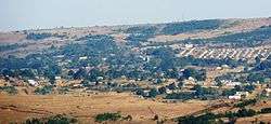
Louwsburg is a small town in northern KwaZulu-Natal, South Africa. Cattle and maize farming are the primary economic activities. The town was proclaimed a township in 1920 and named after Dawid Louw, a pioneer in the area.[2] The town's Zulu name, Ngotshe, means "cave", though its location is unknown. The town is set in a broader region designated as eNgoje. The town's main tourist attraction is the adjacent Itala Game Reserve.
Origin
Dawid Louw (1850-1927) was a member of Lucas Meijer's boer commando, which in 1884, reacted to Dinuzulu's plea for help against his uncle Usibepu, who was usurping the throne. In return for their overthrow of Usibepu, they were granted land in northern Zululand, the future Nieuwe Republiek. Upon the commando's return from the campaign, Louw was allowed to choose a farm, and decided to build his farm house on the eastern slope of Ngotshe Mountain. Here he had the benefit of easy access to water and labour, and named his farm Toggevonde.[3]
Demographics and development
Louwsburg is situated near Vryheid, and resort under one of its municipalities. The majority of people living in this area are Zulus, but a fair number of white South Africans and other groups also live here. Louwsburg continues to grow annually, though slowly. Residents blame the town council for being ineffective and unfair.
The town has one major secondary school named Ngotshe Secondary School and two primary schools of which one is within the town limits. There are several schools outside the town limits. Living conditions in the area are reasonable. Most people are living in the middle-class conditions and live in harmony. There are however reports of escalating youth drinking and AIDS, which is under observation. The town has been visited by several well-known politicians, including chief Mangosuthu Buthelezi and Mr Jacob Zuma.
Emalia decided to improve the lives local residents by starting a nursing college called Nandisa training institute. The courses include HIV, first aid, ancillary, auxiliary, nutrition, and others.[4]
Environment
An area northwest of Louwsburg is characterised by rugged, impenetrable ravines, and is known as "Duiwel se Wêreld" (Afrikaans: Devil's terrain). According to Afrikaner legend, it was the work of the devil, who finding it inferior to God's creation, tore it asunder.[2]
References
- 1 2 3 4 "Main Place Louwsburg". Census 2011.
- 1 2 Raper, P. E. "Dictionary of Southern African Place Names". Onomastic Research Centre, HSRC. Retrieved 21 November 2013.
- ↑ Dames, Koos (2013). Bykans 70 jaar se onthou... pp. 25, 50.
- ↑ http://www.nandisanursing.co.za
![]() Media related to Louwsburg at Wikimedia Commons
Media related to Louwsburg at Wikimedia Commons
Municipalities and communities of Zululand District Municipality, KwaZulu-Natal | ||
|---|---|---|
District seat: Ulundi | ||
| Ulundi | .svg.png) | |
| Nongoma | ||
| Abaqulusi | ||
| uPhongolo | ||
| EDumbe | ||