Panola, Crenshaw County, Alabama
| Panola, Alabama | |
|---|---|
| Unincorporated community | |
|
Panola, Alabama in 2012 | |
 Panola, Alabama  Panola, Alabama | |
| Coordinates: 31°58′18″N 86°23′20″W / 31.97167°N 86.38889°WCoordinates: 31°58′18″N 86°23′20″W / 31.97167°N 86.38889°W | |
| Country | United States |
| State | Alabama |
| County | Crenshaw |
| Elevation | 614 ft (187 m) |
| Time zone | Central (CST) (UTC-6) |
| • Summer (DST) | CDT (UTC-5) |
| Area code(s) | 334 |
| GNIS feature ID | 124399[1] |
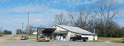
Panola is an unincorporated community in Crenshaw County, Alabama, United States, located 11 miles (18 km) east of Fort Deposit.
References
Municipalities and communities of Crenshaw County, Alabama, United States | ||
|---|---|---|
| Cities | 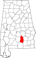 | |
| Towns | ||
| Unincorporated communities | ||
| Footnotes | ‡This populated place also has portions in an adjacent county or counties | |
This article is issued from Wikipedia - version of the 7/31/2016. The text is available under the Creative Commons Attribution/Share Alike but additional terms may apply for the media files.