Panitian, Palawan

Panitian is a barangay in the municipality of Quezon of the province of Palawan, established through Republic Act (R.A.) No. 2593 enacted on June 21, 1959.[1] Panitian was originally a sitio in Quezon, Palawan established by Zambal migrants coming from the northern municipalities of Zambales in 1956 through the National Resettlement and Rehabilitation Administration (NARRA) or Republic Act 1160 of President Ramon Magsaysay in 1954.
The enactment of R.A. 2593 made Panitian the largest barangay of Quezon, Palawan with the inclusion of other sitios under its jurisdiction such as Odiong, Malatgao, Tagpisa, Candis and Napwaran. Due to its enormous size, Panitian allowed Sitio Malatgao to separate and form another barangay before the Philippine barangay elections of 1982. Panitian is bordered on the west by Bgy. Malatgao, on the east by the town proper of Quezon, on the south by the municipality of Sofronio Española, and on the north by the South China Sea.
Located on Panitian's northeasternmost point is the Tabon Cave complex, which is known as the Cradle of Philippine Civilization.
Through NARRA or R.A. 1160, agricultural land distribution and resettlement was carried out by encouraging migration of settlers to open new lands for farming. In Southern Palawan, there was a total of 27 public land subdivisions consisting 20,855 lots of eight hectares per lot that was made available for new settlers (James 1979, p. 29).[2] These homestead lands now comprised the municipality of Narra, Palawan, some barangays of Aborlan and the barangays of Panitian and Malatgao of the municipality of Quezon. Those who migrated to these resettlement areas were Ilocanos from Cagayan Valley (especially in Isabela), the Ilonggos from Panay and Guimaras, Negros, Sultan Kudarat, South Cotabato and North Cotabato and the Sambals from the northern municipalities of Zambales, particularly Masinloc, Candelaria and Santa Cruz.
Pioneering stage

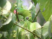
On April 5, 1956, the Zambal migrants, led by an enthusiastic snake hunter and a fiercely built man by the name of Patok, reached Panitian as a jungle, located nine kilometers south of the town of Quezon. The jungle was a habitat of Palawan fruit bats, also known as megabats or "paniki", from which the new inhabitants derived its name. It was first called "Panikian", or land of megabats or "paniki", and later renamed as Panitian. Until the early 1990s, the population of Panitian are treated with a great spectacle starting fifteen to thirty minutes before dusk of thousands of flying megabats blackening the skies migrating towards Puting Bato (towards the direction of Sitio Nali).

The Zambals were given homestead land south of the Municipality of Quezon to be developed for agriculture or into rice farmlands. Eighty to ninety percent of the new settlers received assistance from the government in the form of housing, moving and transportation, food rations for about fifteen months, work animal, farm implements, land clearing and planting materials (James, p. 97). Initially, the Zambals occupied the flat lands in Sitios Sarangsang, Tapsan, Nali and the barangay proper alongside the Panitian River. The Zambals later on came in contact with the friendly Palawans (natives of Palawan) in Sitio Gugnan in 1960s headed by its village chieftain by the name of Ablo. Some of the Zambals purchased lands from the Palawans who had informal claims on some of the arable properties in Gugnan. Others however directly filed land ownership application at the Bureau of Lands District Office in Puerto Princesa City. With the news of land ownership reaching home in Zambales, new waves of Zambal migrants followed. Many of them were able to become landowners, a title that had eluded them in Zambales, acquiring their own farm lands in Sitios Tagpisa, Nali, Tagbanaba and Gugnan despite the absence of the government subsidies the original homesteaders received. More than thirty percent however returned to Zambales after finding Palawan a difficult place to live due to the absence of basic infrastructure, presence of malaria, and the lack of community services that they were accustomed to in the home province.
Many Ilonggo-speaking migrants joined the Zambals in Panitian starting in the 1970s through Sitio Odiong, an area accessible by boats. The Ilonggo migrants were usually fisherfolk coming from other parts of Quezon, Palawan. Many Ilonggos also migrated through Malatgao who then were able to acquire properties in outlying sitios of Panitian.
Sitios

Excluding the barrio-proper of Panitian, the barangay is subdivided into the following sitios:
- Candis
- Gugnan
- Kalatabog
- Kambing
- Marirong
- Nabugsuan
- Nali
- Odiong
- Sarangsang
- Sidanao
- Tabud
- Tagbanaba
- Tagpisa
- Tapsan
- Tugpa
Economic growth
The barangay flourished under the leadership of Barangay Captain Pablo Elefane who served as its barrio captain from the 1960s until 1982. He was ably assisted by Councilor David E. Rombaua who handled most of the daily affairs of Panitian, on behalf of the barangay captain whose residence was in Sitio Sarangsang.
By 1980, notwithstanding the shortage of government support infrastructure such as farm to market roads, irrigation system and credit facilities, Panitian was on its way to the maturity stage of development with sustained growth characterized by the growing urbanization of the barrio proper, increased trade activities and availability of basic community services such as school buildings, a rural health unit, a public market, and barangay recreational facilities. This growth is attributed primarily to four important factors. First, the optimism and pride of settlers on their land ownership and the bayanihan system, or a sense of community that exists among the local population. Second, there are alternative livelihood opportunities like open-ocean fishing in South China Sea, backyard animal raising and vegetable production, and small cottage industries such as fish drying and nipa weaving.

Third, Panitian was endowed with a clean flowing river, the Panitian River, which aside from its invaluable recreational importance served as Panitian's gateway to the poblacion and the South China Sea providing an essential navigational channel for small motorized fishing boats and pumpboats carrying passengers and cargo to and from the municipality of Quezon. Lastly, the presence of the Philippine Marines starting around 1976 contributed significantly to the local economy as their salaries ensure a trickle effect on the local commerce.
The barrio proper was an effective center of economic activities for the local population and residents of outlying sitios. At its peak, there were at least six ricemills operating simultaneously in Panitian. It was common then to see Palawan natives, who customarily walk in a single line one after another, in G-strings or patadyong coming to Panitian to sell their crafts and to manglan or purchase sardines, SSS (tobacco), and candy treats for their kids.
Panitian continued to be a vibrant community until the mid-1980s. This economic vibrancy is best showcased by its celebration of the barangay fiesta or festival held over a period of three days, from April 3 to 5 of each year. The fiesta is filled with sports competitions and betting games, non-stop plaza fair activities, and evening barrio dance and coronation events. Ambulant vendors from other municipalities build temporary nipa stalls around the barangay plaza to sell clothing and household amenities or as halo-halo and food stalls starting as early as the last week of March. The fiesta also attracted traveling circus acts and magicians from Luzon who build their flying trapeze days in advance.
Economic stagnation

The Palawan Integrated Area Development Project or Program (PIADP) of 1979 which had evolved into a legislated government agency, the Palawan Council for Sustainable Development (PCSD) is now on its fourth decade.[3] After all these years, Panitian's economy appeared to have taken a different course, it receded rather than develop or advance and its flora and fauna are deteriorating rapidly. The promise of sustainable development had instead broken the momentum of growth sustained during the first 25 years of Panitian's existence. All the gains during its pioneering and consolidation stages (community development stages, Nelson 1973)[4] were ignored when PIADP prescribed the generic pills of integrated development in this strategic section of southern Palawan - a cure whose side-effect was worse than the initial diagnosis.
Unconcerned with the impact on the local economy of Panitian, the government through PIADP developed a road connecting the Municipality of Rizal to Quezon by-passing Panitian. A huge development faux pas having a tremendous adverse socio-economic impact on the local population, essentially dealing a death blow to the thriving commerce in the barrio. Jeepneys which had morning and afternoon trips to the poblacion had effectively stopped serving the barrio proper. Tricycles would only agree to bring local commuters to the barrio at a special rate. Lakad-system returned and the carusa or the carabao-pulled carriage had made a comeback. Local passengers had to walk to the road junction, about four kilometers from the Panitian public market, to get a ride going to the poblacion, that is if they are lucky enough to catch a jeepney with highly irregular two-trip daily schedules. Otherwise, it would be better to walk five more kilometers to reach the town center, since one had already walked the initial four kilometers anyway.
Local agricultural produce had to be brought to the junction using the carusa before reaching the town market, adding a layer of transport cost which further reduced farm incomes as a result. Land values in the barrio proper suddenly nosedived. Commercial activities had slowly dwindled and one after another sari-sari stores closed shops. Even backyard raised vegetables that used to be traded in the public market had slowly disappeared. Fishermen who usually bring their catch into the Panitian public market were forced to go to the poblacion leaving the local residents with fewer food choices on their daily diet. The same happened with agricultural products coming from Tagbanaba, Tapsan, Sarangsang, Nali and Gugnan.
Ironically, the road project which was intended to bring about economic development had caused instead the very opposite putting the already working local market structures in disarray. It altered the marketing flow and so as the socio-economic growth patterns, the pre-requisites for an agrarian resettlement community to advance from the consolidation stage to maturity stage (Nelson 1973). In effect, the road project denied Panitian - a government-assisted resettlement community, from achieving its ultimate resettlement goal, negating the more than twenty years of hardship and perseverance of its community-conscious residents.
Arguably, the PIADP people, intentionally or unintentionally, blindsided the donors of this negative impact to secure their continued funding under Phase II while working on their tenure and mandates to become a law by R.A. 7611 (SEP Law , Sec. 20). There were delays and problems on project benefit monitoring and evaluation system according to the Asian Development Bank (ADB) Project Completion Report.[5] Apparent reasons why the program's ramification and the adverse socio-economic impact on Panitian were not given attention.
Laissez faire approach disguised under the terms as "integrated area development" or "sustainable development" doomed the local economy of the then thriving barrio - the largest rural economy south of Quezon. Apparently, social and economic development concerns had taken the backseat - a large contrast to the direct government intervention and concern given to the original homesteaders during the pioneering stage of Panitian. Environmental protection, cultural preservation and ancestral domains of tribes, and more government controls are the current priorities under R.A. 7611. This Act is a powerful tool that could be easily abused as a vehicle for political patronage as can be gleaned from the current structure and the "proclamations" that PCSD decrees affecting many aspects of life of the unwary rural Palaweno.[6] The principles of sustainable development are clear, however, the current hands-on policies and actions or the manner by which "development" is approached appears to be a new model, the theoretical foundations thus require more studies.
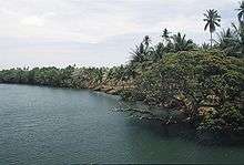
Under PCSD's management, quarrying which provides the needed sands and gravel for the so-called sustainable development initiatives has been destroying the natural beauty of Panitian River. Exacerbated by the dam built upstream for PIADP's communal irrigation system, the river's recreational and aesthetic value appeared unimportant now, notwithstanding Panitian River's significance in bio-diversity. The river is the habitat of the Panitian ulang ilog (Caridina palawanensis), a species of freshwater shrimp found only in Panitian.[7]
Human rights of local residents were often violated by the "sustainable development" police from out-of-towns as they confiscated chain saws of residents which are important in cutting lumber for many of its village crafts. In a civilized society, such confiscations are given due process at the very least, which is clearly absent on how this powerful agency operates. Instead the local residents felt harassed and intimidated.
The environmental and economic decline of Panitian had caused many residents to search for better opportunities away from the barangay they helped established and developed. Many Panitian residents have relocated to Puerto Princesa City, in search of employment opportunities and new livelihood in the urban center - a cyclic pattern in resettlement programs that James (1979) was weary about (p. 134).
Inhabitants
Panitian has a total population of about 7,500 subdivided into five ethno-linguistic subgroupings such as the Zambals, Ilonggo, Ilocano, Muslims in Sitio Odiong, and the Palawan minority found in Sitios Gugnan and Kambing. The Zambals consist about half of the population. The Ilongos comprised 35 percent of the residents, the Ilocanos around 10 percent and the Muslims (5%). The Palawan natives are clustered in small villages with a total population of not exceeding than 300 residents.
Sources of income and livelihood
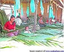
The main sources of income of the local population are rice farming and fishing. Some of the residents are considered farmers during daytime and fishermen during night time. Many residents are also engaged in crafts including production of "pawid" and "sawali" (pandan/nipa and bamboo weaving). Majority of the population are subsistence earners due to the relatively low prices of commodities they produce, inadequate marketing facilities, and unavailability of credits for livelihood projects.
Panitian has the largest Internal Revenue Allotment (IRA) share among all barangays south of Quezon, even including the Municipality of Rizal with P2.93 million for the calendar year 2010.
Community infrastructure
Panitian is accessible from the Municipality of Quezon via a dirt road passable to most vehicles and tricycles during the dry months. Most households in the barrio proper are with electricity. The barangay is served by Level I and II water supply system. On September 28, 2009, the government released its largest ever budget for public works in Panitian in the amount of P2.0 million.[8] This allocation was intended for the construction of flood control system in Panitian. In March 2008, the provincial government had awarded a contract for the construction of waiting sheds in Sitio Tabud and Panitian Proper with a budget of P162,000 per waiting shed.
In December 2009, Executive Order No 683 issued by President Gloria Macapagal Arroyo authorized the Department of Budget and Management (DBM) to issue a Special Allotment Release Order (SARO) containing P2.6 billion Malampaya fund for Palawan. Under this fund is an allotment of P10.7 million for the municipality of Quezon for the improvement of highway junction-Tabud-Panitian Road.
References
- ↑ Republic Act No. 2593 - An Act Creating Certain Barrios in the Province of Palawan, http://laws.chanrobles.com/ph/ra/republicactno2593.html
- ↑ James, W. E. 1979. An Economic Analysis of Public Land Settlement Alternatives in the Philippines. University of Hawaii. London: University Microfilms International
- ↑ Republic Act No. 7611, Section 20, Conversion of PIADPO to PCSD
- ↑ Nelson, M. 1973. The Development of Tropical Lands: Policy Issues in Latin America. Baltimore: Johns Hopkins.
- ↑ Asian Development Bank, PCR:PHI 21049. 2001. Project Completion Report on the Second Palawan Integrated Area Development Project (Loans 1033(SF)/1034-PHI) in the Philippines, p. 8
- ↑ Administrative Orders/PCSD Proclamations/Memorandum Circulars, http://www.pcsd.ph/resolutions/resolutions/admin/index.htm
- ↑ Cai, Y. and S. Shokita. 2006. Report on a Collection of Freshwater Shrimps (Crustacea: Decapoda: Caridea) from the Philippines, with Descriptions of Four New Species. The Raffles Bulletin of Zoology. National University of Singapore.
- ↑ Department of Public Works and Highway Lump Sum Allocation (Regular Releases), As of December 30, 2010, http://www.dbm.gov.ph/pdafreport2.php?legislator=EJERCITO-ESTRADA%2C+JINGGOY+P.&period=2009&fund_type=DPWH&type=senate&spc=no
Coordinates: 9°13′03″N 117°55′29″E / 9.2175°N 117.9247°E