Pangnirtung Airport
Pangnirtung Airport (IATA: YXP, ICAO: CYXP) is located at Pangnirtung, Nunavut, Canada, and is operated by the Government of Nunavut.
In December 2005 the Government of Nunavut announced that they would spend $34.6 million to build a new airport.[4]
Airlines and destinations
Gallery
| Pangnirtung Airport |
|---|
| Pangnirtung airstrip, April 2006 |
| Douglas Super DC-3, taking off from Pangnirtung Airport |
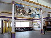
| Interior of the terminal, showing the tapestry woven for the opening of the airport terminal, April 2006 |
| Abeam the Pangnirtung Airport |
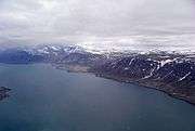
| The town and airport snuggled in beside the mountains |
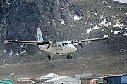
| Air Labrador on short final for runway 24 |
|
References
- ↑ Canada Flight Supplement. Effective 0901Z 15 September 2016 to 0901Z 10 November 2016
- ↑ Synoptic/Metstat Station Information
- ↑ Total aircraft movements by class of operation
- ↑ Nunatsiaq News
- ↑ Flight Schedule and Route Map.
- ↑ First Air Flight Schedule
External links