Pampas, Peru
Coordinates: 12°23′56″S 74°52′0″W / 12.39889°S 74.86667°W
| Pampas | |||
|---|---|---|---|
|
Plaza de Armas, Pampas | |||
| |||
| Nickname(s): Ciudad de los Cuchimichis (The Cuchimichis City) | |||
 Pampas | |||
| Coordinates: 12°23′55.76″S 74°52′12.78″W / 12.3988222°S 74.8702167°W | |||
| Country | Peru | ||
| Region | Huancavelica | ||
| Province | Tayacaja | ||
| Established | 21 June 1825 | ||
| Government | |||
| • Mayor | Jesús Américo Monge Abad | ||
| Area | |||
| • Total | 52.264 km2 (20.179 sq mi) | ||
| Elevation | 3,276 m (10,748 ft) | ||
| Population | |||
| • Total | 11,566 | ||
| • Density | 221.3/km2 (573/sq mi) | ||
| Time zone | PET (UTC-5) | ||
| • Summer (DST) | PET (UTC-5) | ||
| Area code(s) | 067 | ||
| Website | www.munitayacaja.gob.pe | ||


Pampas is a city in Peru. It is the capital of the Tayacaja Province and it was established on June 21, 1825. According to the 2007 census had a population of 9,973 (11,566 in the metropolitan area).[1] It has an approximate altitude of 3,276 metres.
Transportation
The city is connected to the nearby cities like Huancayo and Ayacucho by partially paved roads.
Education
The city house a branch of the Universidad Nacional de Huancavelica and it is home of a local technical institute; the Instituto Tecnologico Pampas - Tayacaja.
Health
The city has now a new hospital, the Hospital Pampas that serve the city and the towns nearby.
Images
 A house in Pampas.
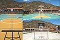 Futsal court in Pampas.
 Slide in the "Parque Ecológico de Pampas".
 Gardens in the "Parque Ecológico de Pampas".
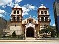 Cathedral of San Pedro de Pampas.
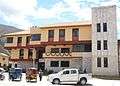 Municipality of Pampas.
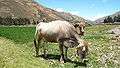 A cow in Pampas.
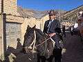 Pampino.

References
- ↑ Instituto Nacional de Estadística e Informática (2007). "Censos Nacionales 2007: XI de Población y VI de Vivienda" (in Spanish). Retrieved November 12, 2008.
Statistics taken of the agglomeration from Acraquia (799), Ahuaycha (794), Daniel Hernández (3.946) and Pampas (6.027)
External links
| Wikimedia Commons has media related to Pampas (ciudad). |
This article is issued from Wikipedia - version of the 8/10/2016. The text is available under the Creative Commons Attribution/Share Alike but additional terms may apply for the media files.