Pains, Santa Maria
| Pains | |
|---|---|
| Bairro | |
 The bairro in District of Pains | |
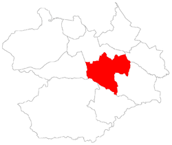 District of Pains, in Santa Maria City, Rio Grande do Sul, Brazil | |
| Coordinates: 29°45′02.18″S 53°42′17.32″W / 29.7506056°S 53.7048111°WCoordinates: 29°45′02.18″S 53°42′17.32″W / 29.7506056°S 53.7048111°W | |
| Country | Brazil |
| State | Rio Grande do Sul |
| Municipality/City | Santa Maria |
| District | District of Pains |
| Area | |
| • Total | 133.61 km2 (51.59 sq mi) |
| Population [1] | |
| • Total | 4,146 |
| • Density | 31/km2 (80/sq mi) |
| Adjacent bairros | Arroio do Só, Camobi, Diácono João Luiz Pozzobon, Lorenzi, Palma, Passo do Verde, Santa Flora, São Valentim, Tomazetti |
| Website | Official site of Santa Maria |
Pains[2] is a bairro in the District of Pains in the municipality of Santa Maria, in the Brazilian state of Rio Grande do Sul. It is located in southest Santa Maria.
Villages
The bairro contains the following villages: Pains, São Sebastião, Passo das Topas, Vila Abrantes, Vila Videira, Vila Marques, Sítio dos Paines, São Geraldo.
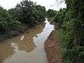
Gallery of photos

 |
Lorenzi / Tomazetti | Diácono João Luiz Pozzobon / Camobi | Palma | |
| São Valentim | |
Arroio do Só | ||
| ||||
| | ||||
| Santa Flora | Passo do Verde | Arroio do Só |
References
This article is issued from Wikipedia - version of the 8/30/2015. The text is available under the Creative Commons Attribution/Share Alike but additional terms may apply for the media files.