Pad, West Virginia
| Pad | |
|---|---|
| Ghost town | |
 Pad Location within the state of West Virginia | |
| Coordinates: 38°38′31″N 81°20′6″W / 38.64194°N 81.33500°WCoordinates: 38°38′31″N 81°20′6″W / 38.64194°N 81.33500°W | |
| Country | United States |
| State | West Virginia |
| County | Roane |
| Elevation | 794 ft (242 m) |
| Time zone | Eastern (EST) (UTC-5) |
| • Summer (DST) | EDT (UTC-4) |
| GNIS ID | 1740965[1] |
Pad is an extinct town in Roane County, West Virginia.
The community took its name from nearby Pad Fork creek.[2]
References
- ↑ U.S. Geological Survey Geographic Names Information System: Pad, West Virginia
- ↑ Kenny, Hamill (1945). West Virginia Place Names: Their Origin and Meaning, Including the Nomenclature of the Streams and Mountains. Piedmont, WV: The Place Name Press. p. 466.
Municipalities and communities of Roane County, West Virginia, United States | ||
|---|---|---|
| City | 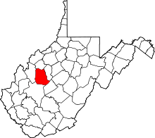 | |
| Town | ||
| Unincorporated communities |
| |
| Ghost towns | ||
| Footnotes | ‡This populated place also has portions in an adjacent county or counties | |
This article is issued from Wikipedia - version of the 9/5/2016. The text is available under the Creative Commons Attribution/Share Alike but additional terms may apply for the media files.