Pennsylvania Route 449
| ||||
|---|---|---|---|---|
 | ||||
| Route information | ||||
| Maintained by PennDOT | ||||
| Length: | 17.131 mi[1] (27.570 km) | |||
| Existed: | 1961 – present | |||
| Major junctions | ||||
| South end: |
| |||
|
| ||||
| North end: |
| |||
| Location | ||||
| Counties: | Potter | |||
| Highway system | ||||
| ||||

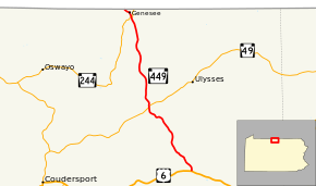
Pennsylvania Route 449 (PA 449) is a 17-mile-long (27 km) state highway located in Potter County, Pennsylvania. The southern terminus is at US 6 in Walton. The northern terminus is the New York state line in Genesee Township.
Route description

PA 449 begins at an intersection with US 6 in the community of Walton in Ulysses Township, heading northwest on Brookland Road. The road heads through forested mountains in the Susquehannock State Forest before coming to the community of Brookland. After passing through more forests, the route enters agricultural areas and becomes Gold Road, intersecting PA 49 in the community of Gold. From this point, PA 449 turns north and continues through a mix of farmland and woodland in a narrow valley. The road briefly enters Allegany Township before heading into Genesee Township and passing through the community of Harmontown. The route runs through more rural areas before intersecting PA 244 in the community of Genesee. PA 244 formed a concurrency through Genesee on Main Street from 2003 until 2011 while the School Street Bridge was closed.[2] Through Genesee, the road passes homes and businesses. PA 449 heads northwest out of Genesee on North Genesee Street into a mix of farms, woods, and homes. PA 449 ends at the New York border, where the road becomes NY 19.[3][4]
Major intersections
The entire route is in Potter County.
| Location | mi[1] | km | Destinations | Notes | |
|---|---|---|---|---|---|
| Ulysses Township | 0.000 | 0.000 | |||
| 7.522 | 12.105 | ||||
| Genesee Township | 16.155 | 25.999 | |||
| 17.131 | 27.570 | New York state line | |||
| 1.000 mi = 1.609 km; 1.000 km = 0.621 mi | |||||
PA 449 Truck
| |
|---|---|
| Location: | Ulysses Township, Pennsylvania |
Pennsylvania Route 449 Truck is a truck route around a weight-restricted bridge over the Pine Creek on which trucks over 32 tons or combination loads over 40 tons are prohibited in Ulysses Township, Pennsylvania in Potter County. The route follows PA 49, PA 44, and US 6. The route was established in 2013.
See also
 U.S. Roads portal
 Pennsylvania portal
References
- 1 2 "Pennsylvania state roads". Pennsylvania Spatial Data Access. Pennsylvania Department of Transportation. 2013. Retrieved March 14, 2013.
- ↑ "New Genesee Bridge Opens to Traffic Friday, Bridge Opening Ceremony in Morning". CoudyNews.com. December 14, 2011. Retrieved March 23, 2013.
- ↑ Google (March 5, 2011). "overview of Pennsylvania Route 449" (Map). Google Maps. Google. Retrieved March 5, 2011.
- ↑ Potter County, Pennsylvania Highway Map (PDF) (Map). PennDOT. 2011. Retrieved March 5, 2011.