Oscoda–Wurtsmith Airport
| Oscoda–Wurtsmith Airport | |||||||||||
|---|---|---|---|---|---|---|---|---|---|---|---|
|
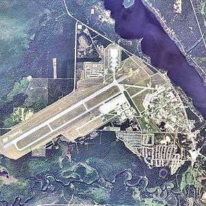
USGS 2006 Airphoto | |||||||||||
| IATA: OSC – ICAO: KOSC – FAA LID: OSC | |||||||||||
| Summary | |||||||||||
| Airport type | Public | ||||||||||
| Owner | Oscoda–Wurtsmith Airport Authority | ||||||||||
| Serves | Oscoda, Michigan | ||||||||||
| Elevation AMSL | 634 ft / 193 m | ||||||||||
| Coordinates | 44°27′06″N 083°23′39″W / 44.45167°N 83.39417°W | ||||||||||
| Map | |||||||||||
 OSC  OSC Location of airport in Michigan/United States | |||||||||||
| Runways | |||||||||||
| |||||||||||
| Statistics | |||||||||||
| |||||||||||
Oscoda–Wurtsmith Airport (IATA: OSC, ICAO: KOSC, FAA LID: OSC) is a public use airport located three nautical miles (6 km) northwest of the central business district of Oscoda, an unincorporated community in Iosco County, Michigan, United States. It is owned by the Oscoda–Wurtsmith Airport Authority.[1] It is included in the Federal Aviation Administration (FAA) National Plan of Integrated Airport Systems for 2017–2021, in which it is categorized as a local general aviation facility.[2]
It was built out of a portion of the decommissioned Wurtsmith Air Force Base which housed nuclear armed B-52 Stratofortress bombers during the Cold War as well as air refueling squadrons.
Oscoda–Wurtsmith Airport became a public airport in 1993. It is primarily a cargo and light general aviation airport with no scheduled passenger services.
The Wurtsmith Base Conversion Authority terminated in 1994, when the Charter Township of Oscoda took over as the Redevelopment Authority. The Authority was organized under Michigan Public Act 206 of 1957. It has five municipal constituents; Oscoda Township, AuSable Township, Greenbush Township, Iosco County and Alcona County. The purpose of the Authority is generally to operate and maintain a public airport. The Michigan Legislature created the Wurtsmith Renaissance Zone in 1997, which exempted businesses and residents of the 5,000 acre (20 km²) zone from all state and most local taxes.
It now occupies a portion of the former base and is primarily used for cargo and light general aviation activities. There is no scheduled passenger service. The Airport offers 24-hour near all weather daily access. Its UNICOM frequency is 123.0 MHz.[3]
Facilities and aircraft
Oscoda–Wurtsmith Airport covers an area of 2,000 acres (810 ha) at an elevation of 634 feet (193 m) above mean sea level. It has one asphalt paved runway designated 6/24 which measures 11,800 by 200 feet (3,597 by 61 m).[1]
For the 12-month period ending December 31, 2005, the airport had 8,857 aircraft operations, an average of 24 per day, all of which were general aviation. In November 2016, there were 24 aircraft based at this airport: 13 single-engine, 8 jet, 2 helicopter and 1 glider.[1]
Of note is the operations of the Yankee Air Force Museum – Wurtsmith Division.[4] Periodic events are held by them.
Kalitta Air has a large operation at the airport.[5]
Other tenants at the former base include the Aune Medical Center, Alcona Health Center Dental Clinic, Alpena Community College, Comprehensive Aviation Training, and numerous private businesses. The former military housing units have been refurbished by the Village of Oscoda, and now serve as a major population base in the Oscoda area. Another portion of the former base houses a community center.
Airline and destinations
Cargo
| Airlines | Destinations |
|---|---|
| Kalitta Air | Cincinnati/Northern Kentucky, Newark, Detroit-Willow Run |
| Omni Air International | Various |
See also
References
- 1 2 3 4 FAA Airport Master Record for OSC (Form 5010 PDF), effective Nov 10, 2016.
- ↑ "List of NPIAS Airports" (PDF). FAA.gov. Federal Aviation Administration. 21 October 2016. Retrieved 25 November 2016.
- ↑ About Oscoda–Wurtsmith Airport
- ↑ Yankee Air Force Museum, Wurtsmith Division
- ↑ Kalittaair.
External links
- FAA Terminal Procedures for OSC, effective December 8, 2016
- Resources for this airport:
- FAA airport information for OSC
- AirNav airport information for KOSC
- ASN accident history for OSC
- FlightAware airport information and live flight tracker
- NOAA/NWS latest weather observations
- SkyVector aeronautical chart, Terminal Procedures