Orbieu
| Orbieu | |
|---|---|
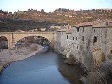 The Orbieu at Lagrasse | |
| Country | France |
| Basin | |
| Main source |
Fourtou 700 m (2,300 ft) 42°55′59″N 02°26′05″E / 42.93306°N 2.43472°E |
| River mouth |
Aude 10 m (33 ft) 43°13′59″N 02°54′00″E / 43.23306°N 2.90000°ECoordinates: 43°13′59″N 02°54′00″E / 43.23306°N 2.90000°E |
| Basin size | 680 km2 (260 sq mi) |
| Physical characteristics | |
| Length | 84.3 km (52.4 mi) |
| Discharge |
|
The Orbieu is a 84.3-kilometre (52.4 mi) long river in the Aude département, in south central France. Its source is at Fourtou, in the Corbières. It flows generally northeast. It is a right tributary of the Aude into which it flows between Raissac-d'Aude and Marcorignan, 10 kilometres (6 mi) northwest of Narbonne.
Communes along its course
This list is ordered from source to mouth: Fourtou, Auriac, Lanet, Montjoi, Vignevieille, Mayronnes, Saint-Martin-des-Puits, Saint-Pierre-des-Champs, Lagrasse, Ribaute, Camplong-d'Aude, Fabrezan, Ferrals-les-Corbières, Lézignan-Corbières, Luc-sur-Orbieu, Cruscades, Ornaisons, Névian, Villedaigne, Raissac-d'Aude, Marcorignan
Notes
- This article is based on the equivalent article from the French Wikipedia, consulted on 29 April 2009.
References
| Wikimedia Commons has media related to Orbieu. |
This article is issued from Wikipedia - version of the 6/5/2016. The text is available under the Creative Commons Attribution/Share Alike but additional terms may apply for the media files.