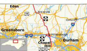
North Carolina Highway 86
| ||||
|---|---|---|---|---|
 | ||||
| Route information | ||||
| Maintained by NCDOT | ||||
| Length: | 53.1 mi[1] (85.5 km) | |||
| Existed: | 1940[2] – present | |||
| Major junctions | ||||
| South end: |
| |||
|
| ||||
| North end: |
| |||
| Location | ||||
| Counties: | Orange, Caswell | |||
| Highway system | ||||
| ||||

North Carolina Highway 86 (NC 86) is a 53.1-mile-long (85.5 km) state highway in North Carolina that runs north and south through Caswell and Orange counties from Chapel Hill, North Carolina to the Virginia state line at Danville. The highway primarily links up the towns of Chapel Hill, Hillsborough, and Yanceyville, along with providing a route between Chapel Hill and Virginia. Between Chapel Hill and Hillsborough, NC 86 serves as an alternative to Interstate 40 (I-40).
Route description
NC 86 travels north from its southern terminus at US 15-501/NC 54 Bypass (Fordham Boulevard) in Chapel Hill, passing through the UNC campus and the town center. Exiting Chapel Hill into rural Orange County, NC 86 meets I-40 before arriving in Hillsborough. There, the route meets I-85 and then joins NC 57 for about a mile through Hillsborough's central business district. Splitting to the northwest (signed north), NC 86 briefly joins NC 49 as they cross the Caswell County line.
Entering the small community of Prospect Hill, NC 86 splits from NC 49 and travels north toward Yanceyville. Just outside Yanceyville, NC 86 joins U.S. 158 and crosses NC 62. After passing through central Yanceyville, US 158 splits west while NC 86 continues north to the state line, where the route continues as State Route 86 and travels into Danville.
History
Prior to 1940, this was numbered as NC 14. It was renumbered to match up with Virginia's State Route 86. Simultaneous with that change, the old NC 65 was renumbered as NC 14.
Old North Carolina Highway 86, (sometimes referred to as Old 86), is a highway that parallels North Carolina Highway 86. Heading from NC 54 near Carrboro, it follows northwest to Homestead/Dairyland Road near the unincorporated community of Calvander, North Carolina, it heads north paralleling Interstate 40 until the intersection at exit 261. Then intersecting Interstate 85, at exit 164, it ends at the intersection with U.S. Route 70 Business, and North Carolina Highway 86. The highway was moved to the more heavily-traveled corridor between Chapel Hill and Hillsborough in the 1950s.[2]
Major intersections
| County | Location | mi[1] | km | Destinations | Notes |
|---|---|---|---|---|---|
| Orange | Chapel Hill | 0.0 | 0.0 | Interchange | |
| | 5.5– 5.7 | 8.9– 9.2 | Exit 266 (I-40) | ||
| Hillsborough | 12.1– 12.3 | 19.5– 19.8 | Exit 165 (I-85); southern terminus of NC 86 Truck | ||
| 12.8 | 20.6 | Southern end of US 70 Bus. Concurrency | |||
| 14.5 | 23.3 | Northern end of US 70 Bus. Concurrency | |||
| 14.8 | 23.8 | Northern terminus of NC 86 Truck | |||
| | 15.2 | 24.5 | Southern terminus of NC 57 | ||
| | 27.0 | 43.5 | Southern end of NC 49 concurrency | ||
| Caswell | Prospect Hill | 27.5 | 44.3 | Northern end of NC 49 concurrency | |
| Hightowers | 34.3 | 55.2 | |||
| | 38.9 | 62.6 | Southern end of US 158 concurrency | ||
| Yanceyville | 41.9 | 67.4 | Southern end of NC 62 concurrency | ||
| 42.1 | 67.8 | Northern end of NC 62 concurrency | |||
| 44.2 | 71.1 | ||||
| | 53.1 | 85.5 | Virginia state line | ||
1.000 mi = 1.609 km; 1.000 km = 0.621 mi
| |||||
Bannered routes
Hillsborough truck route
| |
|---|---|
| Location: | Hillsborough, North Carolina |
| Length: | 8.3 mi[3] (13.4 km) |
North Carolina Highway 86 Truck (NC 86 Truck) is a bypass route for truck drivers that are traveling through the city of Hillsborough. This 8.3-mile (13.4 km) route goes west around the entire city, via I-85 (between exits 165 and 160), I-85 Connector and US 70. The routing is well marked throughout and there are warning signs for truck drivers, including "tolerance ends," for that continue through the city.
References
- 1 2 Google (May 7, 2015). "North Carolina Highway 86" (Map). Google Maps. Google. Retrieved May 7, 2015.
- 1 2 NCRoads.com: N.C. 85 to 89
- ↑ Google (May 13, 2014). "NC 86 Truck - Hillsborough, North Carolina" (Map). Google Maps. Google. Retrieved May 13, 2014.
External links
 Media related to North Carolina Highway 86 at Wikimedia Commons
- NCRoads.com: N.C. 86