Old Kilpatrick
| Old Kilpatrick | |
| Scottish Gaelic: Cille Phàdraig[1] | |
| Scots: Auld Kilpaitrick[2] | |
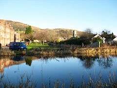 Old Kilpatrick and the Kilpatrick Hills, seen across the Forth and Clyde Canal |
|
 Old Kilpatrick |
|
| OS grid reference | NS463729 |
|---|---|
| Council area | West Dunbartonshire |
| Lieutenancy area | Dunbartonshire |
| Country | Scotland |
| Sovereign state | United Kingdom |
| Post town | Glasgow |
| Postcode district | G60 |
| Police | Scottish |
| Fire | Scottish |
| Ambulance | Scottish |
| EU Parliament | Scotland |
| UK Parliament | West Dunbartonshire |
| Scottish Parliament | Clydebank and Milngavie |
Coordinates: 55°55′30″N 4°27′33″W / 55.9250°N 4.4593°W
Old Kilpatrick (Scots: Auld Kilpaitrick, Scottish Gaelic: Cille Phàdraig meaning "Patrick's church"), is a village in West Dunbartonshire, Scotland.
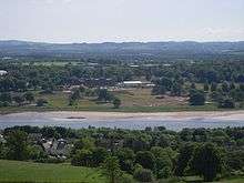
The village is on the north bank of the River Clyde immediately to the north of the Forth and Clyde Canal, 3 miles (5 km) from Clydebank on the road to Dumbarton. The Great Western Road runs through Old Kilpatrick, and the next village to its west is Bowling. The modern A82 trunk road runs to the north of Old Kilpatrick, between the village and the foot of the Kilpatrick Hills. There is a legend that it was the birthplace of Saint Patrick.
Roman fort
The western end of the Antonine Wall was at Old Kilpatrick (the eastern end, 59 km distant was at Bridgeness, to the east of Bo'ness on the Firth of Forth). The physical traces of the wall have been erased but the route was surveyed during the 18th century and traced to the Chapel Hill where various Roman artefacts were found.[3]
When the Forth and Clyde Canal was being dug in 1790 the remains of a bathhouse were discovered. In 1913 the foundations of the fort which had been conjectured as being in the vicinity were confirmed. In 1923 during redevelopment of the area significant archaeology was undertaken, which established the size and nature of the fort. Established around 81 AD, it occupied an area of about four acres enclosed by an outer defensive wall. If the date is correct it shows that the fort preceded the Antonine Wall by some sixty years. Internally, buildings discovered included a praetorium (headquarters), barracks and a granary.[4] Major development precluded further significant excavation, and nothing is visible of the remains today; the remains lie beneath the houses of Gavinburn Gardens to the east, a large commercial building to the west and the A814 road to the north.
Later history
The parish system was introduced to Scotland in the 13th century. In about 1227, the church and lands of Kilpatrick were given to Paisley Abbey by Maldowen, Earl of Lennox. The parish remained under the supervision of the Abbey until the Reformation in 1560.[5]
At the Dissolution, the Church property fell into the possession of Lord Sempill. Eventually the lands were conferred on Claude Hamilton (a boy of ten), founder of the Abercorn family.[6] His son James Hamilton was created Lord Abercorn on 5 April 1603, then on 10 July 1606 he was made Earl of Abercorn and Lord of Paisley, Hamilton, Mountcastell and Kilpatrick.
Kilpatrick was split into two parishes - Old (Wester or West) and New Kilpatrick (also known as Easter or East) by an Act of Parliament on 16 February 1649.[7][8] This division is unusual because this was a split of both the ecclesiastical and civil parishes and the wealth and stipend of the original parish was shared between the two new parishes. It was more common for new parishes to have "daughter" status, with wealth retained by the central, or cathedral church.[5]
Old Kilpatrick was created a Burgh of barony in 1697.[9] Its population tripled between 1755 and 1821 as the spinning and weaving industries developed. By 1831 the population was 5,800.[9]
Today, the north end of the Erskine Bridge, which replaced the Erskine Ferry, lands just above the village, and the village is served by Kilpatrick railway station on the North Clyde Line.
There are three public houses within Old Kilpatrick; The Twisted Thistle, The Ettrick [10] and the Glen Lusset. The Twisted Thistle was previously known as the Telstar. After the closure of The Telstar, the building was renovated and reopened in 2014 as The Twisted Thistle.[11]
There are two annual fêtes which are well attended. Also at the north end of Old Kilpatrick is the local school. Gavinburn Primary School (which was bombed in WW2) where they also have many fêtes annually.
The minerals edingtonite and thomsonite were first found at Old Kilpatrick.[12]
In the early 1990s a large housing estate was constructed at the edge of Old Kilpatrick, the one estate was said to double the size of Old Kilpatrick.
The ancient graveyard surrounding the old parish church still has surviving gravestones from the 17th century. The current building dates from 1812 and is still in use as the local Church of Scotland parish church, now linked with neighbouring Bowling Parish Church.[13]
The local Roman Catholic church is St. Patrick's RC Church; the current parish priest is Fr. Francis Wilson.[14] Sadly a fire in August 2015 saw the RC congregation temporarily without a place to worship, taking up the kind offer of the nearby Church of Scotland congregation to use their building, a friendly act of ecumenism in part of Scotland traditionally torn by bigotry.[15]
Notable people
- Chris Baillie
- Scott Cuthbert, footballer
- Bobby Finan footballer.
- Ian Niall, or John McNeillie, a writer, was born here.
- This is one of several locations that it is suggested that Saint Patrick of Ireland was captured at and enslaved in Ireland in the fifth century.
See also
References
- ↑ List of railway station names in English, Scots and Gaelic – NewsNetScotland
- ↑ The Online Scots Dictionary
- ↑ Statistical Accounts of Scotland 1834-45 vol 8 p21
- ↑ Miller, S.N. (1924) The Roman Fort at Old Kilpatrick, Glasgow Archaeological Society.
- 1 2 McCardel, J (1949). The Parish of New Kilpatrick. University Press Glasgow.
- ↑ Leicester Addis, ME (1901). The Cathedrals and Abbeys of Presbyterian Scotland. The Westminster Press.
- ↑ The Records of the Parliaments of Scotland to 1707, K.M. Brown et al (St Andrews University) Date accessed: 13 September 2011
- ↑ History of Drumchapel
- 1 2 Statistical Accounts of Scotland 1834-45 vol 8 p23
- ↑ http://www.theettrick.com/
- ↑ http://www.glenlusset.com/about
- ↑ Alec Livingstone, 2002, Minerals of Scotland, Edinburgh, National Museums of Scotland
- ↑ http://www.west-dunbarton.gov.uk/leisure-parks-events/tourism-and-visitor-attractions/museums-and-galleries/collections/buildings/places-of-worship/old-kilpatrick-parish-church-1893/
- ↑ http://www.rcag.org.uk/parishes_stpatricks_oldkilpatrick.htm
- ↑ http://www.heraldscotland.com/news/homenews/13621539.Place_to_worship_offered_after_Old_Kilpatrick_church_fire/?ref=fbshr
External links
| Wikimedia Commons has media related to Old Kilpatrick. |
- Clydebank Through A Lens — a documentary about Clydebank, Scotland from the 1960s to '80s
- Post-Blitz Clydebank — a documentary about Clydebank, Scotland from 1947 to 1952
- Video footage of Ferrydyke Quay and Bascule Bridge.
- Video footage of Donald's Quay Stables, Ferrydyke Quay.