A82 road
| |
|---|---|
|
The route of the A82 in Scotland | |
| Route information | |
| Length: | 167 mi[1] (269 km) |
| History: |
Classified as A82 1923[2] Specific sections built 1724 - present[3] |
| Major junctions | |
| From: | Glasgow |
| |
| To: | Inverness |
| Location | |
| Primary destinations: | |
| Road network | |

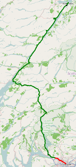
The A82 is a road in Scotland that runs from Glasgow to Inverness by way of Fort William. The majority of the route is a trunk road and hence managed by Transport Scotland, who view the road as a vitally important link through the Scottish Highlands and beyond.
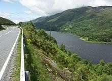
The road passes close to some of the most notable landmarks in the Highlands, including Loch Lomond, Rannoch Moor, Glen Coe, Ben Nevis, the Commando Memorial, Loch Ness and Urquhart Castle. Several travel guides have praised individual parts of the road, such as the section from Tyndrum to Glencoe across Rannoch Moor, as providing memorable driving experiences. At 167 miles (269 km),[1] the road is the second longest A-road in Scotland, after the A9, and has been described as the "slower but more scenic route" of the two.[4]
The A82 has an extensive history. It is derived in several places from the military roads constructed through the Highlands by General Wade and Major Caulfeild during the early to mid 18th century,[3] along with later roads constructed by Thomas Telford in the early 19th. The modern route is based on that designed by Telford, but with a number of improvements primarily dating from the 1920s and '30s. These include a diversion across Rannoch Moor[5] and another around Loch Leven, which was subsequently replaced by the Ballachulish Bridge.
The A82 is a popular route for tourists due to its extensive scenery, and it serves as the main artery for commercial and heavy goods traffic through the area. Transport Scotland have publicly declared a commitment to improve the road, and a number of congestion and safety improvements are being made. Parts of the road are occasionally closed for maintenance, which has resulted in strong protest from the local community.
Route
The A82 was one of the first trunk roads, which were created in 1936, and has historically been described in official government documentation as part of the "London - Carlisle - Glasgow - Inverness Trunk Road" in which the A6 and A74 make up the rest of the route.[6] On 1 April 1996, however, the section from Glasgow to the Dalnottar Interchange with the A898 was detrunked.[7] The main length of the A82, as managed by Transport Scotland, is now described in statutory instruments and orders as the "Dalnottar - Inverness Trunk Road".[8] From Glasgow to Dalnottar, the route is now the responsibility of the Glasgow City Council and the West Dunbartonshire Council in their respective areas.
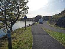
St George's Cross – Alexandria
_-_geograph.org.uk_-_1769095.jpg)
The A82 begins in the St George's Cross area of central Glasgow, at a junction with the M8 and the A804. (NS582663) From here, it heads in a northwest direction along the Great Western Road for 3 miles (4.8 km) towards Anniesland Cross and passes a number of the city's most notable terraces, including Alexander "Greek" Thomson's Great Western Terrace, constructed in 1867,[9] and Devonshire Terrace[10]:185 before widening to dual carriageway at Kelvinside.[11] The road here was originally built as a turnpike road in 1816[12] and widened to its current state in the early 1970s. All the trees along the route were preserved due to environmental concerns. The Great Western Road has been described by Tam Galbraith as "the most noble entry to any city in Europe."[13]
The road continues beyond Anniesland Cross as an extension of the Great Western Road, which was constructed between 1922 and 1924[14] and hence easier to widen to dual carriageway in the 1970s than the earlier 19th century section.[13] It approaches a freeflow junction with the A898 from Erskine Bridge, which since the completion of the M74 through the south of Glasgow is now the main signposted route from the south to Loch Lomond and eliminates the need for through traffic to travel along Great Western Road.
The road continues northwest as a high quality dual carriageway route through Dumbarton before running to the west of Alexandria and Bonhill on a bypass constructed in the late 1960s.[15] This dual carriageway ends at the Balloch Roundabout near the western shore of Loch Lomond, where the road enters the Loch Lomond and The Trossachs National Park.
Alexandria – Crianlarich
The A82 follows the Luss Road along the western shores of the loch, through Arden to Luss. Toward Crianlarich, it follows the general route of the Old Military Road[16] that runs along the shoreline in several places, but it generally keeps some distance to the west. Much of this section of the road was widened to a high quality single carriageway standard over the 1980s, at an estimated cost of £24 million,[17] while Luss itself is now bypassed to the west of the village along a single carriageway bypass constructed between 1990 and 1992.[18][19]
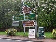
At Tarbet (NN319044), the A83 branches west to Campbeltown while the A82 continues to the north end of the loch. This part of the road is currently of a lower standard than the sections further south. It is sandwiched between the shoreline of the loch and the mountains to the west, and it runs generally alongside the West Highland Line. The road narrows to less than 7.3 metres (24 ft) in places and causes significant problems for heavy goods vehicles (HGVs), which have to negotiate tight bends and the narrow carriageway width. For over 30 years a set of traffic signals at Pulpit Rock (NN326135) allowed traffic to use the full width of the road until 2015, when the construction was completed of a new viaduct which brought the road to a more suitable width.[20] The north end of the loch is at Ardlui, after which the A82 continues to follow the Highland Line along Glen Falloch, a typical glacial valley, towards Crianlarich. After passing the main station, the A82 runs underneath the West Highland Line to Oban and meets the A85, which runs east to west along the central Highlands. (NN384253) By 2015 Transport Scotland had completed the construction of a bypass of the village, running along 0.81 miles (1.3 km) of single carriageway on a new alignment from the south to the north.[21]
Crianlarich – Glencoe
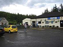
The A82 and A85 share the same route for 5 miles (8.0 km) between Crianlarich and Tyndrum. Although Crianlarich has a larger community, Tyndrum is equally well catered for motorists, particularly HGV drivers, and contains the Real Food Cafe, a transport cafe that stays open until 10pm.[22] The cafe caters not only to motorists but also to walkers along the West Highland Way.[23]
The A82 enters bleak moorland at the western fringes of Rannoch Moor, to the north of Tyndrum. This section of road has a particularly extensive history, as a route through the moor was followed by Major Caulfeild, and a later route was constructed by Telford. The modern route of the A82 dates from the 1930s.[24] This section of this road follows Telford's road as far as Bridge of Orchy, then runs to the east of Loch Tulla, while the old road runs to the other side.[25][26] The new road was constructed because Telford's road had continual problems with flooding around Loch Tulla. Telford himself had proposed a completely alternative route, running to Spean Bridge via Loch Treig and Glen Spean. His plans were never implemented, though that route eventually formed part of the West Highland Railway, which remains the case today.[24] The road climbs uphill across the moor and reaches a peak height of 348 metres (1,142 ft) near Beinn Chaorach, the highest point on all of the A82.[27]
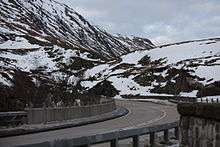
The old and new roads meet near the Kingshouse Hotel next to the River Etive, and the road turns westward past Buachaille Etive Mòr down Glen Coe towards Glencoe village.[28] This section of the A82 has been said to contain some of the most spectacular scenery in Scotland. The Guardian's Simon Warren described it as "the most beautiful and spectacular location in the whole of Britain",[29] though recent concern has been raised over the proliferation of tourist traffic. Coaches and HGVs in particular have caused significant problems with congestion.[30]:137 The road descends the Pass of Glen Coe and crosses the scenic waterfalls at the Meeting of the Three Waters. This section was the location for several outdoor shots in Monty Python and the Holy Grail, most notably the "Gorge of Eternal Peril" scene.[31] Near the waterfalls is a footpath up to Coire Gabhall, the "lost valley" of Glencoe, where the Clan Donald hid stolen cattle.[28]
The modern A82 splits from Telford's route just before the Clachaig Inn, a popular location for tourists due to its proximity to the site of the Massacre of Glencoe, as noted by a sign in the reception that reads, "No hawkers or Campbells".[28] The A82 runs to the west of the River Coe and passes the modern visitors' centre before Glencoe village itself.[32]
Glencoe – Fort William
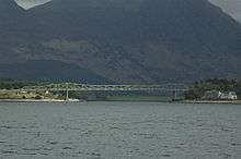
The A82 continues along the south shore of Loch Leven beyond Glencoe, bypasses Ballachulish, and crosses the mouth of the loch via the Ballachulish Bridge. This bridge had been proposed since the mid-1960s,[33] and construction began in late 1972[34] at an estimated cost of £2m. An arch bridge had been the suggested design, but an asymmetrical N-truss bridge was built instead.[35] A bearing failure on one of the supports caused delays while the rest of the structure was examined to confirm its safety,[36] and it eventually opened in December, 1975.[37] It contains individual spans of 29 metres (95 ft), 180 metres (600 ft) and 82 metres (269 ft) from south to north.[35] Prior to the opening of the bridge the alternative to the ferry was to take the 16 mls (25 km) trip along the then A82 - since renumbered B863 - around Loch Leven via Kinlochleven.
At a roundabout, prior to the rise towards the bridge, the A828 continues south around the coast towards Connel and Oban. Just behind and to the left of the A82, as it commences to cross the bridge, is a monument to the Appin Murder that reads, "Erected in 1911 to the memory of James Stewart of Acharn, or James of the Glen, executed on this spot Nov. 8, 1752, for a crime of which he was not guilty."[10]:106–107
After passing through North Ballachulish and Onich the A82 turns to run northward along the Great Glen, which it continues to do for the remainder of the route up to Inverness. It passes the A861 to the Corran Ferry over to Ardnamurchan in the west. The road here, as it was previously along Loch Lomond, is tightly situated between Loch Linnhe and the mountains up to Fort William, which is located about 7 miles (11 km) from the Corran narrows. Various hotels and bed and breakfasts are situated along the road approaching Fort William, indicating the area's esteem of tourism.[10]:106–107 The route of the old military road - from King's House/Altnafeadh on Rannoch Moor via Kinlochleven - rejoins the route of the modern A82, at the West End roundabout, just before the High Street in the town centre. Today, the A82 follows a brief dual carriageway bypass along the shoreline of the loch before passing the 'new' (1975) station. A branch road runs east through Glen Nevis to Ben Nevis, while the A82 turns to cross the River Nevis. To the north of town the A830 "Road to the Isles" runs west to Glenfinnan and Mallaig.
Fort William – Inverness
_-_Commando_Memorial%2C_Spean_Bridge_-_geograph.org.uk_-_967265.jpg)
North of Fort Willam, the A82 runs alongside the West Highland Railway through Leanachan Forest towards Spean Bridge. It crosses the River Spean at a bridge constructed by Telford in 1819, but the village is named for the earlier 'High Bridge' constructed in 1735/6 by General Wade about 0.5 miles (0.80 km) to the west.[38] There is a junction with the A86, which runs eastwards towards Newtonmore and the Cairngorms. The Commando Memorial, a 5.2 metres (17 ft) high structure dedicated to the original Commandos in World War II, who used the local area as a training ground, is located just north of the village at a junction with the B8004 to Gairlochy. This memorial provides one of the best viewpoints of the Highlands that is close to the A82.[38]
The A82 then follows the eastern shore of Loch Lochy up to Laggan. The village has no clearly defined centre but broadly follows the course of the A82 over 1.2 miles (2 km), from the Laggan Locks on the Caledonian Canal to the swing bridge that separates the canal from Loch Oich. This bridge is close to the "Well of the Seven Heads" monument, which allegedly contains the heads of seven men involved in the murder of Alexander MacDonald, Chief of Keppoch, and his brother, on 25 September 1663.[39]:128–129
The A82 runs towards the centre of Loch Oich, passes Invergarry Castle, and crosses the River Garry. Just after the bridge, the A87 heads west towards the Isle of Skye, while the A82 continues along the western shore of the loch up to the Bridge of Oich at its northern end. This bridge was constructed in 1932, bypassing the 1850s Bridge of Oich Taper Suspension Bridge built by James Dredge.[39]:126 The A82 continues along the general line of Wade's Military road up to Fort Augustus crossing the canal at a swing bridge next to the locks in the village.[39]:123
The final 36 miles (58 km) from Fort Augustus to Inverness mostly follow the alignment of Telford's Road, which runs along the western shore of Loch Ness.[40][41] This is on the opposite side of the loch to Wade's Military Road, because Telford wanted to connect the various communities along the western shore. Construction of the road started in 1805[39]:118 but was delayed in 1807, when the building contractors abandoned the work with seven bridges yet to be completed.[42] It was mostly complete by 1809[43] at an estimated cost of £5,800.[44]
Because the A82 is a main through route, tourists are suggested to use the older Military Road instead, so as to avoid the coach and HGV traffic.[30]:151 Cyclists and walkers can now use the Great Glen Way between Fort Wiilam and Inverness. This is part of the, yet incomplete, Sustrans Route 78 - The Caledonia Way - from Campbeltown to Inverness.
There is a short diversion from the loch at Invermoriston, where the A82 crosses the River Moriston and the A887 provides another route back to the A87 and Skye. Telford's original stone bridge over the river, constructed in 1813, has been replaced by a more modern structure.[40] Between Invermoriston and Drumnadrochit, there is a roadside memorial to John Cobb, who was killed on the loch attempting to beat the water speed record.[45] As the A82 approaches Drumnadrochit, it passes Urquhart Castle before turning inland, away from the loch shore, to approach the village.
The A82 continues at the north end of the loch, along the western edge of the River Ness, which runs parallel alongside the canal towards Inverness city centre. Immediately after entering the urban area, the road crosses the canal at the Tomnahurich Swing Bridge.[46] Now inside Inverness, the road passes Queen's Park stadium and heads towards the city centre. It crosses the Ness at the Friar's Bridge, bypassing the city centre to pass through the docklands and associated industrial estates as an urban dual carriageway. The road ends at a roundabout with the A9 just south of Kessock Bridge. (NH673467)
History
The original route of the A82 as classified in 1923 was described as "Glasgow - Clydebank - Dumbarton - Alexandria - Crianlarich - Ballachulish - Fort William - Fort Augustus - Inverness"[2] and closely follows the route as designed by Telford.[47] With only a few exceptions, the basic route has remained unchanged.
Route within Glasgow
The original starting point of the A82 in Glasgow was at Trongate. It proceeded to run westwards along Argyle Street and Dumbarton Road to Dumbarton via Clydebank.[48] On 16 May 1934, the road was rerouted to run along Buchanan Street, New City Road and Great Western Road, whose westward extension from Anniesland Cross had been recently completed.[6] The route between Glasgow and Dumbarton has since broadly remained the same, aside from the declassification of the route to the south of the M8 when that motorway was constructed.
Kinlochleven
The original route of the A82 crossed Loch Leven at the Ballachulish Ferry, in a similar location to today's bridge, but there was then no through route around the loch.[49] However, the development of the aluminium works at Kinlochleven and the construction of the Blackwater Dam in 1907[50] resulted in the construction of a new road around the full extent of the loch, from Glencoe to North Ballachulish, by the 1930s. On 16 May 1934, the Ministry of Transport announced they would divert the A82 along this road, principally because it was an all-day route while the ferry at that time closed daily between 8:00pm and 8:00am and cost up to 5 shillings to use.[6] It continued to follow the route via Kinlochleven until the opening of the Ballachulish Bridge. The Kinlochleven road is now the B863, but still remains an important local road since the town reinvented itself as a tourist destination following the close of the smelter works in 2000.[51]
Inverness
The A82 originally ended on the A9 to the west of the Ness Bridge near Inverness City Centre.[52] The current diversion over the Friars Bridge towards the modern A9 opened in 1986,[53] in co-ordination with the redevelopment and extension of Inverness docks in the early 1980s[54] and the rerouting of the A9 onto the Kessock Bridge.[55] The A82 now acts as an access road to the docklands.
Gaelic signs
The A82 runs through some of the Gaelic-speaking areas in Scotland, known as the Gàidhealtachd. In 2003, the Scottish Government announced that it would install bilingual signs on a number of trunk roads, including the A82 from Tarbet to Inverness. Transport Minister Lewis Macdonald hoped that the signs would improve the tourism experience in the Highlands, as well as improve awareness of the Gaelic Language.[56]
In 2009, the Highland Council urged Transport Minister Stewart Stevenson to erect more bilingual signs along sections of the road. A spokesman for Transport Scotland said, "The Scottish Government wants to see a continued increase in the visibility of Gaelic in Scotland, building on a notable increase in recent years."[57] Their introduction has been controversial, as motorists have questioned why budgets have been spent on these signs instead of on improvements to the road.[58]
Economic importance
.jpg)
The Scottish Government have said that the A82 is "a vital artery for communities in the western Highlands and links Fort William, the Highlands and the Western Isles with Glasgow and the Central Belt."[60] The Highlands and Islands Transport Partnership (HITRANS) believe the economic benefits of the A82 extend far beyond its basic route, as it connects with several other trunk roads to the Western Highlands and related islands, including all of the Western Isles and the Isle of Skye. The population of the area served around the A82 corridor is expected to decline from 78,900 in 2001 to 72,300 by 2018,[61]:1 with the vast majority of depopulation to occur in the Western Isles.[61]:2
HITRANS believe investment in the A82 is therefore vitally important to improve the accessibility of these areas and stop the continuing population decline.[61]:2 They have noted that improvements to the A9 in the 1970s stimulated the economy of Inverness: "Without the improved access as a result of the A9 improvement, this would almost certainly not have been possible."[61]:7 The partnership believe that with comparable improvements to the A82, an additional income of £76 million could be generated in the area.[61]:5 First Minister Alex Salmond has stated that the government is "committed to improving the A82", and he allocated £500,000 in June 2011 to study key areas where the route could be improved.[62] Scottish Transport Minister Keith Brown has called the A82 a "vital economic and social lifeline".[59]
Maintenance and improvements
The A82, along with the A9, has been frequently regarded as one of the most dangerous roads in Scotland. HITRANS have said that "of the 147 miles (237 km) between Balloch and Inverness, only 42 miles (68 km) can be considered to be of a functional standard."[61]:1 A campaign group, the A82 Partnership, has been set up to encourage the Scottish government to continue to make improvements to the route.[62] In 2002, the A82 between Tarbet and Tyndrum was listed as the third most dangerous Scottish road in an AA study. The Scottish executive debunked the report as "misleading".[63] A further study listed in the 2012 Collins Big Road Atlas did not list the A82 as one of the most at risk to safety.[62]
The A82 around Loch Lomond has become increasingly congested as the loch has become more popular with tourists for boating, particularly since restrictions were put in place in the Lake District, coincident with improvements to routes leading to the Loch from the south. On regular occasions, the road is completely congested from Luss to the Balloch roundabout.[64] The section from Tarbet to Crianlarich, north of the section improved in the 1980s and 90s, was frequently closed overnight during September 2012, because the carriageway had become worn out and needed urgent repair, including failed surfacing and potholes. Because of the narrow width of the road, it was not possible to simply close the road in one direction at a time with temporary traffic signals, as is the general procedure elsewhere on Britain's road network. Transport Scotland justified these works by saying that only 5% of traffic used the road between 10pm and 6am, when the works were planned.[65]
The section at Pulpit Rock has been described by Transport Scotland as "a significant engineering challenge for decades." They plan to improve 400 metres (440 yd) of the existing A82 by building a 180-metre (200 yd) viaduct running parallel to the loch shoreline, followed by a further 180-metre (200 yd) online widening by cutting into the headland along the rock. The new road will be to modern two-way traffic standards and remove the requirement for traffic signals.[20] Work started on these improvements in May 2013 and will take approximately 12 months to complete.[66] The official diversion route from Tarbet to Crianlarich is via the A83, A819 and A85,[67] a detour of approximately 30 miles (48 km).[20] Commenting on the works, Brown said "Our commitment to improve the traffic flow at Pulpit Rock is unwavering and, on completion, this project will bring real benefits for businesses and communities in the Highlands and Islands, not least the haulage industry."[68]
In March 2013, Transport Scotland announced that work would start on the Crianlarich Bypass some time in the summer, and continue for 12 months.[59] In addition to the expected improvements in traffic flow, Brown also believed that the reduced noise and congestion in the village would benefit residents.[69]
Because most of the A82 is single carriageway, and the local geography means a detour can be a significant distance, there is a history of strong protest about closing the road. In August 2011, John Grieve, owner of Lochleven Shellfish Company, attempted to challenge Transport Scotland's plans to close the A82 overnight five days a week, for a period of up to three weeks, around the village of Onich, between Glencoe and Fort William.[70] The Scottish Herald reported that, if the road closed, a journey from Oban to Fort William, normally 44 miles (71 km), would require diverting via Loch Tay and Ballinluig, a journey of 166 miles (267 km). Stewart MacLean from the A82 Partnership said, "The proposal to close the road is ludicrous because there is no reasonable detour ... There are commercial vehicles running all the time. The delivery vehicles, the fish farm lorries, refrigerated wagons, they all need to get through."[71] In April 2013, Transport Scotland announced further plans to close the A82 at Onich for resurfacing, but they postponed the work due to an adverse reaction from local business owners.[72]
Along with several other roads in the Highlands, the A82 between Tyndrum and Glencoe has been installed with permanent gates that are closed in the event of severe weather.[73] These gates are now fitted with fibre-optic illuminated signs.[74]
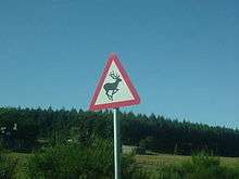
The A82 has been identified as one of several trunk roads in the Highlands that suffers from problems with deer-vehicle collisions (DVCs).[75] In 1996, Transport Scotland set up a number of vehicle activated warning signs alerting drivers attention to nearby deer. Four of these signs are on the A82 between Tyndrum and Glencoe.[76]
See also
References
- 1 2 "Google Maps : M8 J17 - Longman Roundabout, Inverness" (Map). Google Maps. Google. Retrieved 9 July 2013.
- 1 2 Ministry of Transport (Roads Department) (1923). List of class I and class II roads and numbers. HMSO. p. 63.
- 1 2 "General Wade's bridges and roads". Education Scotland. Retrieved 8 July 2013.
- ↑ Olson, Donald; Brewer, Stephen; Strachan, Donald; Shelby, Barry (2012). Frommer's Great Britain Day by Day. John Wiley & Sons. p. 626. ISBN 9780470648698.
- ↑ Wright, Peter (2010). Ribbon of Wilderness: Discovering the Watershed of Scotland. Luath Press Ltd. p. 162. ISBN 9781906817459.
- 1 2 3 "Renumbering of Classified Routes". The National Archives. 1933–1942. MT 39/246.
- ↑ "Statutory Instruments 1995 No. 1476 (S.107)". HM Government. 8 June 1995. Retrieved 9 July 2013.
- ↑ "Traffic Scotland : About Us". Retrieved 9 July 2013.
- ↑ McFadzean, Ronald (1979). The Life and Work of Alexander Thomson. Routledge. p. 297. ISBN 9780710000699.
- 1 2 3 Miers, Richenda (2006). Scotland. New Holland Publishers. ISBN 9781860113390.
- ↑ Landranger Series of Great Britain (Map). 1:50 000. Ordnance Survey. Retrieved 8 July 2013.
- ↑ "Great Western Road". Gazetteer for Scotland. 2013. Retrieved 8 July 2013.
- 1 2 Galbraith, Tam (5 May 1971). "Passenger transport authority : Glasgow". Hansard. Retrieved 8 July 2013.
- ↑ Dilke, Margaret S; Templeton, Archibald Angus (1959). The County of Dunbarton. Collins. p. 248.
- ↑ Ross, William (1 May 1968). "A82 Trunk Road (Alexandria Bypass)". Hansard. Retrieved 8 July 2013.
- ↑ Taylor, William (1996). The Military Roads in Scotland. Dundurn. p. 142. ISBN 9781899863082.
- ↑ Ancram, Michael (6 July 1983). "A82 (Loch Lomond)". Hansard. Retrieved 8 July 2013.
- ↑ Douglas-Hamilton, James (20 June 1990). "Roads". Hansard. Retrieved 8 July 2013.
- ↑ Douglas-Hamilton, James (1 February 1994). "Trunk Roads". Hansard. Retrieved 8 July 2013.
- 1 2 3 "A82 Pulpit Rock Improvement Environmental Statement Non-Technical Summary". Transport Scotland. 23 September 2010. Retrieved 9 July 2013.
- ↑ "A82 Crianlarich Bypass". Transport Scotland. Retrieved 23 September 2015.
- ↑ Humphreys, Donald; Reid (2011). The Rough Guide to Scottish Highlands & Islands. Rough Guides UK. pp. 278–279. ISBN 9781405389402.
- ↑ Cowan, Tam (30 March 2013). "Tam Cowan's restaurant review: The Real Food Cafe, Tyndrum, Perthshire". Daily Record. Retrieved 9 July 2013.
- 1 2 Taylor, William (1996). The Military Roads in Scotland. Dundurn. p. 70. ISBN 9781899863082.
- ↑ Ten Mile Road Map of Great Britain (Map). 10 miles / inch. Ordnance Survey. 1932. Sheet 1.
- ↑ Ten Mile Road Map of Great Britain (Map). 10 miles / inch. Ordnance Survey. 1939. Sheet 1.
- ↑ Landranger Series of Great Britain (Map). 1:50 000. Landranger series of Great Britain. Ordnance Survey. Retrieved 10 July 2013.
- 1 2 3 Smith, Roly (18 November 2000). "Monarch of the glens". The Guardian. Retrieved 10 July 2013.
- ↑ Warren, Simon (13 July 2012). "Britain's top 10 cycle climbs". The Guardian. Retrieved 15 July 2013.
- 1 2 Mitchell, Nick (2012). The End to End Cycle Route: Land's End to John o' Groats. Cicerone Press Limited. ISBN 9781849656412.
- ↑ Larsen, Darl (2008). Monty Python's Flying Circus: An Utterly Complete, Thoroughly Unillustrated, Absolutely Unauthorized Guide to Possibly All the References. Scarecrow Press. p. 348,356. ISBN 9781461669708.
- ↑ Steves, Rick (2012). Rick Steves' Snapshot Scotland. Avalon Travel. p. 190. ISBN 9781598809947.
- ↑ Ross, William (4 February 1965). "Bridge, Ballachulish". Hansard. Retrieved 9 July 2013.
- ↑ Younger, George (9 May 1972). "Dornoch Firth Bridge". Hansard. Retrieved 9 July 2013.
- 1 2 "Ballachulish Bridge". Royal Commission on the Ancient and Historical Monuments of Scotland. Retrieved 9 July 2013.
- ↑ Kenworthy, David (7 November 1975). "Ballachulish Bridge". Hansard. Retrieved 9 July 2013.
- ↑ Mitchell, William Reginald (1977). Highland Autumn. R. Hale. p. 82. ISBN 9780709160625.
- 1 2 Castle, Alan (2011). The Speyside Way. Cicerone Press Limited. p. 63. ISBN 9781849653558.
- 1 2 3 4 Dillon, Paddy (2011). The Great Glen Way: Two Way Trail guide. Cicerone Press Limited. ISBN 9781849654166.
- 1 2 Lonely Planet : Great Britain. Lonely Planet. 2013. p. 1996. ISBN 9781743216415.
- ↑ Porter, Darwin; Prince, Danforth (2008). Frommer's Scotland. John Wiley & Sons. p. 337. ISBN 9780470249123.
- ↑ "Fourth Report of the Commissioners for Road and Bridges in the Highlands of Scotland". House of Commons. 1809: 10. Retrieved 11 July 2013.
- ↑ Fifth Report of the Commissioners for Roads and Bridges in the Highlands of Scotland. House of Commons. 11 April 1811. p. 10. Retrieved 11 July 2013.
- ↑ "Sixth Report of the Commissioners for Roads and Bridges in the Highlands of Scotland". House of Commons. 24 February 1813: 12–13. Retrieved 11 July 2013.
The Invermorrison [sic] Road ... was originally estimated at nearly Four Thousand Eight Hundred Pounds ... The continuation of the Invermorrison [sic] Road to Fort-Augustus (thus completing the full length of Loch-Ness) ... price was Six Hundred Pounds, to which we found reason to add upon successive Estimates Four Hundred Pounds
- ↑ Hogg, Lynne; Hogg, Ronald Wallace (2007). FreeToDo Travel Guide UK & Ireland. FreeToDo Travel Guides. p. 17. ISBN 9780955360008.
- ↑ "Traffic eases as swing bridge fixed at Tomnahurich". Inverness Courier. 8 July 2013. Retrieved 13 July 2013.
- ↑ John Thomson's Atlas of Scotland (Map). 1832. Retrieved 10 July 2013.
- ↑ Glasgow and Firth of Clyde (Map). Half inch / mile. Ministry of Transport Road Map. Ordnance Survey. 1923. Sheet 26.
- ↑ Ben Nevis (Map). Half inch / mile. Ministry of Transport Road Map. Ordnance Survey. 1923. Sheet 18.
- ↑ Gray, Alastair McIntosh; Moffat, William (1989). A History of Scotland, Book 5. Oxford University Press. p. 33. ISBN 9780199170630.
- ↑ Townsend, Chris (2011). Scotland : World Mountain Ranges. Cicerone Press Limited. p. 187. ISBN 9781849653534.
- ↑ Inverness and Nairn (Map). Half inch / mile. Ministry of Transport Road Map. Ordnance Survey. 1923. Sheet 9. Retrieved 10 July 2013.
- ↑ BBC (1986). "Domesday Reloaded : Friar Bridge Redevelopment". Retrieved 10 July 2013.
- ↑ The Dock and Harbour Authority. 63. Foxlow Publications, Limited. 1982. p. 251.
- ↑ "Kessock Bridge roadworks: £1.8m plan to ease disruption". BBC News. BBC. 18 October 2012. Retrieved 10 July 2013.
- ↑ "Bilingual road signs rolled out". Scottish Government. 20 January 2003. Retrieved 10 July 2013.
- ↑ "'Fast track' hope for sign review". BBC News. BBC. 12 March 2009. Retrieved 9 July 2013.
- ↑ "No sign of Gaelic cutbacks!". Highland News. 13 February 2010. Retrieved 8 July 2013.
- 1 2 3 "Improvement work to start on A82 at Crianlarich". BBC News. BBC. 21 May 2013. Retrieved 9 July 2013.
- ↑ "A82 Improvements". Transport Scotland. Retrieved 8 July 2013.
- 1 2 3 4 5 6 "A82 Tarbet to Fort William : Economic Appraisal" (PDF). Highlands and Islands Transport Partnership. September 2005. Retrieved 10 July 2013.
- 1 2 3 "Collins atlas rates five Scottish A roads 'high risk'". BBC News. BBC. 19 August 2011. Retrieved 9 July 2013.
- ↑ "Danger road report 'misleading'". BBC News. BBC. 18 February 2002. Retrieved 9 July 2013.
- ↑ Galbraith, Sam (13 February 1996). "National Parks (Scotland)". Hansard. Retrieved 8 July 2013.
- ↑ "A82 Tarbet to Crianlarich maintenance works – Q&A". Transport Scotland. Retrieved 9 July 2013.
- ↑ "A82 Pulpit Rock". Transport Scotland. Retrieved 9 July 2013.
- ↑ "Pulpit Rock work to take 11 months". Dumbarton Reporter. 18 June 2013. Retrieved 9 July 2013.
- ↑ "Work to ease traffic at Pulpit Rock on A82 Loch Lomond". BBC News. BBC. 29 January 2013. Retrieved 9 July 2013.
- ↑ "Five firms invited to bid for A82 work". Highways Magazine. 21 May 2013. Retrieved 9 July 2013.
- ↑ "A82 works closure challenged by Lochaber businessman". BBC News. BBC. 5 August 2011. Retrieved 13 July 2013.
- ↑ "Drivers in 166-mile detour if Highland road is closed". The Herald. 4 August 2011. Retrieved 9 July 2013.
- ↑ "Onich A82 work postponed to 2014". The Oban Times. 10 April 2013. Retrieved 9 July 2013.
- ↑ "Snow causes road problems in parts of Scotland". BBC News. BBC. 2 January 2012. Retrieved 15 July 2013.
- ↑ "Street Lighting". The Highland Council. Retrieved 15 July 2013.
- ↑ "National Deer-Vehicle Collisions Project Scotland" (PDF). The Deer Initiative. 2003–2005. Retrieved 10 July 2013.
- ↑ "Vehicle Activated Deer Warning Signs" (PDF). Transport Scotland. April 2010. Retrieved 10 July 2013.
External links
| Wikimedia Commons has media related to A82 road (Scotland). |
- SABRE : A82 - an extensive history of the road, including specific alignments and relationships to Wade and Telford's roads
- Three Generations of the A82 - an in depth analysis of the route across Rannoch Moor
- The A82 Partnership - campaign site for upgrading the road
A roads in Zone 8 of the Great Britain road numbering scheme | ||
|---|---|---|
Coordinates: 55°52′11″N 4°16′03″W / 55.8698°N 4.2674°W