Oklahoma State Highway 26
| ||||
|---|---|---|---|---|
 | ||||
| Route information | ||||
| Maintained by ODOT | ||||
| Length: | 7.97 mi[1] (12.83 km) | |||
| Major junctions | ||||
| South end: |
| |||
| North end: |
| |||
| Highway system | ||||
| ||||

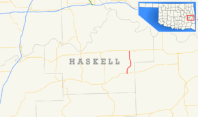
State Highway 26 (abbreviated SH-26 or OK-26) is a state highway in Oklahoma. It runs for a total of 7.97 miles (12.83 km),[1] south-to-north, in eastern Haskell County. SH-26 serves as a link between SH-31 and SH-9. There are no letter-suffixed spur highways branching from SH-26.
Route description
SH-26 begins at SH-31 on the west side of McCurtain. For its entire length, the highway alternates between passing through forested areas and clearings. It travels eight miles (13 km) in a curving path to the north to the intersection with SH-9, two miles (3 km) west of Keota.
Junction list
The entire route is in Haskell County.
| Location | mi[1] | km | Destinations | Notes | |
|---|---|---|---|---|---|
| McCurtain | 0.00 | 0.00 | Southern terminus | ||
| | 7.97 | 12.83 | Northern terminus | ||
| 1.000 mi = 1.609 km; 1.000 km = 0.621 mi | |||||
References
- 1 2 3 Oklahoma Department of Transportation (December 5). Control Section Maps: Haskell County (PDF) (Map). Scale not given. Oklahoma City: Oklahoma Department of Transportation. Retrieved 2010-06-08. Check date values in:
|date=(help)
External links
This article is issued from Wikipedia - version of the 10/21/2016. The text is available under the Creative Commons Attribution/Share Alike but additional terms may apply for the media files.