Oissel
| Oissel | ||
|---|---|---|
| ||
 Oissel | ||
|
Location within Normandy region  Oissel | ||
| Coordinates: 49°20′33″N 1°05′32″E / 49.3425°N 01.0922°ECoordinates: 49°20′33″N 1°05′32″E / 49.3425°N 01.0922°E | ||
| Country | France | |
| Region | Normandy | |
| Department | Seine-Maritime | |
| Arrondissement | Rouen | |
| Canton | Saint-Étienne-du-Rouvray | |
| Intercommunality | CREA | |
| Government | ||
| • Mayor (2008 - 2014) | Thierry Foucaud | |
| Area1 | 22.19 km2 (8.57 sq mi) | |
| Population (2006)2 | 11,611 | |
| • Density | 520/km2 (1,400/sq mi) | |
| Time zone | CET (UTC+1) | |
| • Summer (DST) | CEST (UTC+2) | |
| INSEE/Postal code | 76484 / 76350 | |
| Elevation |
2–128 m (6.6–419.9 ft) (avg. 10 m or 33 ft) | |
|
1 French Land Register data, which excludes lakes, ponds, glaciers > 1 km² (0.386 sq mi or 247 acres) and river estuaries. 2 Population without double counting: residents of multiple communes (e.g., students and military personnel) only counted once. | ||
Oissel is a commune in the Seine-Maritime department in the Haute-Normandie region in northern France.
Geography
A suburban and light industrial town situated by the banks of the river Seine, just 8 miles (13 km) south of Rouen at the junction of the D18 and the D13 roads. Junction 22 of the A13 autoroute is entirely within the commune’s borders. SNCF operates a TER rail service here.
Heraldry
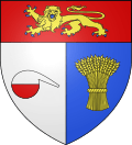 |
The arms of Oissel are blazoned : Per pale argent and azure, a half-filled alembic gules and a garb Or, and on a chief gules, a leopard Or, armed and langued azure. |
Population
| 1962 | 1968 | 1975 | 1982 | 1990 | 1999 | 2006 |
|---|---|---|---|---|---|---|
| 9936 | 9949 | 10,501 | 11,712 | 11,444 | 11,053 | 11,611 |
| Starting in 1962: Population without duplicates | ||||||
People
- Daniel Horlaville, footballer born in 1945.
- Raoul Grimoin-Sanson (1860–1941), cinematographic inventor.
- Grégory Tafforeau, footballer born in 1976.
- Thierry Foucaud, 1954-, Politician.
Places of interest
- The church of St.Martin, dating from the nineteenth century.
- The sixteenth century manorhouse, the Manoir de La Chapelle.
- The Dambray Pavillon, from the seventeenth century.
- The Château de La Perreuse.
See also
References
External links
| Wikimedia Commons has media related to Oissel. |
- Oissel official website (French)
- Pictures of Oissel, the photoblog of an osselien.
- Oissel on the Quid website (French)
This article is issued from Wikipedia - version of the 7/21/2016. The text is available under the Creative Commons Attribution/Share Alike but additional terms may apply for the media files.