Ohio State Route 195
| ||||
|---|---|---|---|---|
 | ||||
| Route information | ||||
| Maintained by ODOT | ||||
| Length: | 3.588 mi[1] (5.774 km) | |||
| Existed: | 1923[2][3] – present | |||
| Major junctions | ||||
| South end: |
| |||
| North end: |
| |||
| Location | ||||
| Counties: | Hardin | |||
| Highway system | ||||
| ||||

State Route 195 (SR 195) is a 3.6-mile-long (5.8 km) north–south state highway in the western portion of the U.S. state of Ohio. SR 195 has its southern terminus at an intersection with Hardin County Route 110 one mile (1.6 km) south of the village of McGuffey. Its northern terminus is at its junction with SR 309 about two miles (3.2 km) north of McGuffey. It is entirely located within western Hardin County.
SR 195 was created in the middle of the 1920s. Much of this two-lane highway outside of McGuffey travels amidst mostly open countryside. Before the 2010s, SR 195 continued south along the banks of the Scioto River to SR 235 in Roundhead Township. A majority of the portion of former SR 195 south of McGuffey traveled along the western banks of the Scioto River in one of its northernmost and narrowest stretches.
Route description
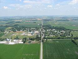
The route begins at a four-way intersection in Marion Township where Hardin County Route 110 travels east and west and CR 65 heads south. SR 195 heads due north and enters McGuffey just prior to its intersection with Cottonwood Road.[4] As it passes through the village along Courtright Street, the highway passes amidst both homes and commercial businesses, as well as Upper Scioto Valley High School. Prior to departing McGuffey, SR 195 crosses a former railroad grade, and is abutted on the east side by some woods. As it re-enters Marion Township, the route enters back into open farm country, with a couple of homes appearing along the way. SR 195 crosses CR 90, and continues north past a small patch of woods amidst a few homes on the east side just prior to meeting TR 84. After intersecting CR 80, the route goes by a few more homes amidst the open fields prior to arriving at its endpoint at SR 309. Continuing north after SR 195 terminates is CR 65, which goes on to intersect SR 701 less than 0.50 miles (0.80 km) to the north.
This state highway is not included as a part of the National Highway System (NHS). The NHS is a network of routes that are identified as being most important for the economy, mobility and defense of the country.[5]
History
SR 195 was designated in 1923. The original route was 9.42 miles (15.16 km) long and traveled from SR 235 (SR 69 prior to 1968) in Roundhead Township and traveled east and northeast through portions of Roundhead, McDonald, and Marion townships before transitioning to its present routing through McGuffey and ending at SR 309 (formerly SR 10 and U.S. Route 30S).[6][7] The route had utilized this alignment through western Hardin County throughout most of its lifetime.[2][3] Beginning in 1995, the portion of SR 195 along the Scioto River between CR 150 and CR 110 began sliding into the river. Between 1995 and 2010, this stretch of road would be closed six times with repairs totaling US$1,000,000.[8][9] Ohio Department of Transportation (ODOT) officials determined that the peaty soil of the Scioto Marsh and the construction of this section of the road to lower specifications caused the road to slip into the river.[9] In 2014, ODOT truncated SR 195's southern terminus to the intersection with CR 110 with the drivable portions of the former state highway becoming county and township-maintained roads.[1]
Major intersections
The entire route is in Hardin County.
| Location | mi[1] | km | Destinations | Notes | |
|---|---|---|---|---|---|
| Marion Township | 0.000 | 0.000 | |||
| 3.588 | 5.774 | ||||
| 1.000 mi = 1.609 km; 1.000 km = 0.621 mi | |||||
References
- 1 2 3 "ODOT TIMS Viewer (showing current and former portions of SR 195)". Ohio Department of Transportation. Retrieved July 26, 2014.
- 1 2 Map of Ohio State Highways (MrSID) (Map). Cartography by ODHPW. Ohio Department of Highways and Public Works. April 1922. Retrieved 2011-05-06.
- 1 2 Map of Ohio Showing State Routes (MrSID) (Map). Cartography by ODHPW. Ohio Department of Highways and Public Works. July 1923. Retrieved 2011-05-06.
- ↑ Google (July 26, 2014). "Ohio State Route 195" (Map). Google Maps. Google. Retrieved July 26, 2014.
- ↑ National Highway System: Ohio (PDF) (Map). Federal Highway Administration. December 2003. Retrieved 2011-05-07.
- ↑ ODOT. "Technical Services Straight Line Diagrams: SR 195, Hardin County" (PDF). Retrieved 2011-05-06.
- ↑ Hardin County (PDF) (Map). ODOT. June 2012. Retrieved July 26, 2014.
- ↑ Staff (March 27, 2012). "Hardin residents voice concerns on State Route 195 construction". WLIO. Retrieved July 26, 2014.
- 1 2 Staff (March 3, 2010). "State mulls Route 195 fix". The Lima News. Retrieved July 26, 2014.