Nyírbátor
| Nyírbátor | ||
|---|---|---|
| ||
| Country |
| |
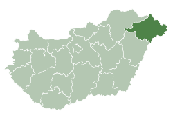
| County | Szabolcs-Szatmár-Bereg | |
| Area | ||
| • Total | 66.73 km2 (25.76 sq mi) | |
| Population (2015) | ||
| • Total | 12,259[1] | |
| • Density | 183.7/km2 (476/sq mi) | |
| Time zone | CET (UTC+1) | |
| • Summer (DST) | CEST (UTC+2) | |
| Postal code | 4300 | |
| Area code(s) | 42 | |

Nyírbátor (Hungarian pronunciation: [ˈɲiːɾbaːtoɾ]) is a town in Szabolcs-Szatmár-Bereg county, in the Northern Great Plain region of eastern Hungary. With its historic atmosphere, this city is known for its 15th- and 16th-century ecclesiastic and secular architectural heritage and for the Báthory family, former landowners.
Geography
It covers an area of 66.73 km2 (26 sq mi) and has a population of 12,259 (2015).[1]
History
The first written record of the settlement dates from 1279. Its name stems from the Old Turkish word 'batir' or Mongolian 'bator' (originally meaning a 'good hero', and corresponding to 'bátor' in modern Hungarian). At that time, the ancestors of the Báthorys, the Gutkeled clan, already owned the land. The town became the administrative centre of their estates and also the family burial site. The family owned the town until the death of Gabriel Báthory, Prince of Transylvania in 1613.
The town was of great significance in Hungarian history during the 16th century. In 1549, the legates of King Ferdinand I and of Isabella agreed to return Transylvania to the Kingdom of Hungary. During the decades that followed there was a lasting dispute as to whom the town belonged since the local aristocrats were more inclined to recognise the sovereignty of the ruling prince of Transylvania.
By the 18th century the town had become impoverished. In the course of the 1872 reorganisation of public administration it lost its city rights that were returned only in 1973.
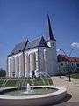
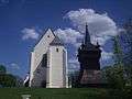
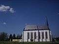
Numerous heritage buildings have remained from the town's heyday. The best known is what is now the Reformed Church. Built between 1488 and 1511, it is one of the most beautiful International Gothic structures in Hungary. The late Renaissance-style belfry next to it is the largest wooden bell tower in the country.
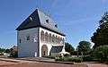
Franciscan monks built their monastery church around 1480 in a late Gothic style. Its altars and its pulpit are among the most beautifully carved Baroque works in the country. Standing near the church is the building which now houses the István Báthori Museum. Originally a Baroque Minorite monastery, it was built on the site of an earlier monastery.
Photo gallery


Notable people
- Elizabeth Bathory (1560-1614), Hungarian countess and most prolific female serial killer in history
- Meshulam Gross (1863–1947), Hungarian-American entrepreneur
International relations
Twin towns — sister cities
Nyírbátor is twinned with:
See also
References
- 1 2 Gazetteer of Hungary, 1st January 2015. Hungarian Central Statistical Office. 03/09/2015
Coordinates: 47°50′N 22°08′E / 47.833°N 22.133°E