Nostrand Avenue (IND Fulton Street Line)
| Nostrand Avenue | |||||||||||
|---|---|---|---|---|---|---|---|---|---|---|---|
| New York City Subway rapid transit station | |||||||||||
|
A view of the upper level | |||||||||||
| Station statistics | |||||||||||
| Address |
Nostrand Avenue & Fulton Street Brooklyn, NY 11216 | ||||||||||
| Borough | Brooklyn | ||||||||||
| Locale | Bedford-Stuyvesant | ||||||||||
| Coordinates | 40°40′49″N 73°56′58″W / 40.680345°N 73.949575°WCoordinates: 40°40′49″N 73°56′58″W / 40.680345°N 73.949575°W | ||||||||||
| Division | B (IND) | ||||||||||
| Line | IND Fulton Street Line | ||||||||||
| Services |
A C | ||||||||||
| Transit connections |
| ||||||||||
| Structure | Underground | ||||||||||
| Levels | 2 | ||||||||||
| Platforms | 4 side platforms (2 on each level) | ||||||||||
| Tracks | 4 (2 on each level) | ||||||||||
| Other information | |||||||||||
| Opened | April 9, 1936[1] | ||||||||||
| Traffic | |||||||||||
| Passengers (2015) |
5,762,163[2] | ||||||||||
| Rank | 77 out of 422 | ||||||||||
| Station succession | |||||||||||
| Next north |
Franklin Avenue (local): A Hoyt–Schermerhorn Streets (express): A | ||||||||||
| Next south |
Kingston–Throop Avenues (local): A Utica Avenue (express): A | ||||||||||
| |||||||||||
| |||||||||||


Nostrand Avenue is a two-level express station on the IND Fulton Street Line of the New York City Subway, located at the intersection of Nostrand Avenue and Fulton Street in Brooklyn. It is served by the A train at all times and the C train at all times except late nights.
History
The Nostrand Avenue station opened on April 9, 1936, as part of an extension of the Independent Subway System (IND) from its previous Brooklyn terminus at Jay Street – Borough Hall, which opened three years earlier, to Rockaway Avenue.[1] The new IND subway replaced the BMT Fulton Street El. The Nostrand Avenue El station, which was formerly above the current subway station, closed on May 31, 1940.[3]
In 1981, the MTA listed the station among the 69 most deteriorated stations in the subway system.[4]
In the early morning hours of February 17, 2005, transit workers found two trash bags on the tracks of this station. They contained the body parts of 19-year-old Rashawn Brazell, who was reported missing three days earlier, of Bushwick, Brooklyn. The case, considered one of the most gruesome in New York City history, is still under investigation as the murderer(s) have not been identified and no arrests have been made.[5]
Station layout
| G | Street Level | Exit / Entrance |
| B1 Express platforms |
North Mezzanine | Fare control, stairways to northbound local platform and to Exits/Entrances |
| Side platform, doors will open on the right | ||
| Northbound express | ← | |
| Southbound express | → Street, or Lefferts Boulevard (Utica Avenue) → | |
| Side platform, doors will open on the right | ||
| South Mezzanine | Fare control, stairways to southbound local platform and to Exits/Entrances | |
| B2 Local platforms |
Side platform, doors will open on the right | |
| Northbound local | ← (Franklin Avenue) | |
| Wall | ||
| Trackway | No service | |
| Trackway | No service | |
| Wall | ||
| Southbound local | → | |
| Side platform, doors will open on the right | ||
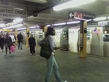
Nostrand Avenue is the only two-level express station in the system that has the express tracks on the upper level and the local tracks on the lower one. The station was originally planned to be a conventional local station with four tracks and two side platforms, with a mezzanine, as proven by the fact that the upper level platforms are wider than the lower level ones (which would have been consistent with the design of a mezzanine), and two unused trackways exist on the lower level between the local tracks (which would have been consistent with the typical design of a local station on a four-track line). A curtain wall separates the local tracks from the unused trackways on both sides. On either side of the station, the express tracks ascend from the local tracks to serve the upper level, then descend to rejoin them.
The station's trim-line is Butterscotch yellow with a medium Mustard brown border and is three tiles high on all of the platform walls as well as the track walls on the lower level. Below the trim-line is "NOSTRAND" tiled in white on a black border and name tablets that read "NOSTRAND AVE." in white sans-serif font on the same (but reversed) contrasting color background and border (mustard brown/butterscotch yellow).
The platforms have directional signs to the other level in the same style as the name tablets and signs to the exit in the same style as the name tiles. Each upper level platform has its own same-level fare control, and there are no crossovers or crossunders.[6] This is one of only three express stations in the system that do not allow free transfers between directions. The others are 86th Street on the IRT Lexington Avenue Line and Bergen Street on the IND Culver Line (the lower level of the latter is not currently in use). Each fare control area has a turnstile bank, token booth, and two street stairs. The Manhattan-bound side stairs lead to both northern corners of Nostrand Avenue and Fulton Street while the Queens-bound side stairs lead to both southern corners.[6]
From the northbound platform's south end a hole in the wall allows a bright flashlight beam to show the unused trackways.
Exits
| Exit location[7] | Number of exits | Platform served |
|---|---|---|
| SW corner of Nostrand Avenue and Fulton Street | 1 | Southbound |
| SE corner of Nostrand Avenue and Fulton Street | 1 | Southbound |
| NW corner of Nostrand Avenue and Fulton Street | 1 | Northbound |
| NE corner of Nostrand Avenue and Fulton Street | 1 | Northbound |
Each platform has its own exits to the corners of Nostrand Avenue and Fulton Street; the northbound platform has exits to either northern corner, while the southbound platform has exits to either southern corner.[7] The station also has a closed passageway with a crossover to Bedford Avenue at the railroad north (geographical west) end of the upper level, and a closed exit to Arlington Place leading only to the northbound platforms.[6][7]
References
- 1 2 "NEW SUBWAY LINK OPENED BY MAYOR; He Tells 15,000 in Brooklyn It Will Be Extended to Queens When Red Tape Is Cut.". The New York Times. 1936-04-09. ISSN 0362-4331. Retrieved 2016-08-15.
- ↑ "Facts and Figures: Annual Subway Ridership". Metropolitan Transportation Authority. Retrieved 2016-04-19.
- ↑ New York Times, Last Train is Run on Fulton St. 'El', June 1, 1940
- ↑ Gargan, Edward A. (June 11, 1981). "AGENCY LISTS ITS 69 MOST DETERIORATED SUBWAY STATIONS". The New York Times. Retrieved 13 August 2016.
- ↑ Search is on for dismemberment killer America's Most Wanted Retrieved 2008-06-13
- 1 2 3 "Review of the A and C Lines" (PDF). Metropolitan Transportation Authority. December 11, 2015. Retrieved 19 January 2016.
- 1 2 3 "NYC DoT Maps: Nostrand Av (A)(C)" (PDF). mta.info. New York City Department of Transportation. 2016. Retrieved 5 July 2016.
External links
- nycsubway.org – IND Fulton Street Line: Nostrand Avenue
- Station Reporter — A Lefferts
- Station Reporter — A Rockaway
- Station Reporter — C Train
- The Subway Nut — Nostrand Avenue Pictures
- Nostrand Avenue entrance from Google Maps Street View