North Carolina Highway 91
| ||||
|---|---|---|---|---|
 | ||||
| Route information | ||||
| Maintained by NCDOT | ||||
| Length: | 12.244 mi[1][2] (19.705 km) | |||
| Existed: | 1947 – present | |||
| Major junctions | ||||
| South end: |
| |||
|
| ||||
| North end: |
| |||
| Location | ||||
| Counties: | Greene | |||
| Highway system | ||||
| ||||

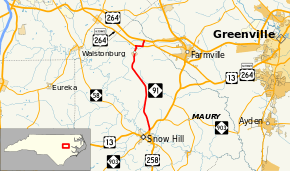
North Carolina Highway 91 is a 12.244-mile (19.705 km) highway running from US 13 / US 258 / NC 903 in Snow Hill to US 264 near Walstonburg.
Route description
NC 91 begins at an intersection with US 13/US 258/NC 903 north of the main business district of Snow Hill. The highway immediately heads north into a rural area of eastern North Carolina. Many farms and forests are present along the first several miles of the highway, along with a community college and a high school. After crossing Washington Branch Church Road, NC 91 passes by several industrial farms. Running through the unincorporated community of Castoria, the highway passes a fire station and several small homes before turning to the northwest. Roughly paralleling Sandy Run, the highway continues through a rural area, however more houses are located adjacent to the road, than the section near Snow Hill. Approaching Evermay Farm Road, the highway turns to the north and then slightly northeast. The road turns back to the north before intersecting Fields Road. NC 91 enters Walstonburg along Wilson Street. In the central part of the town, Wilson Street crosses a railroad operated by Carolina Coastal Railway. The highway passes by several small businesses and a post office, before leaving the town to the north. The highway passes by several industrial manufacturers and a fire station between Walstonburg and US 264 Alternate. Approaching US 264 Alternate, several small neighborhoods appear adjacent to the highway. Once reaching US 264 Alternate, the highway turns right to follow the highway to the east. The two highways follow concurrently for 0.8-mile (1.3 km) until NC 91 splits to the north. For the final section of NC 91, the highway follows along Bell Road. The adjacent land is primarily forests, and several swamps are located. NC 91 ends at an interchange with US 264 (exit 59), north of Walstonburg.[2][3]
Major intersections
The entire route is in Greene County.
| Location | mi[4] | km | Destinations | Notes | |
|---|---|---|---|---|---|
| Snow Hill | 0.0 | 0.0 | |||
| Walstonburg | 10.7 | 17.2 | Western end of US 264 Alt. concurrency | ||
| | 11.6 | 18.7 | Eastern end of US 264 Alt. concurrency | ||
| | 12.3 | 19.8 | Exit 59 (US 264) | ||
1.000 mi = 1.609 km; 1.000 km = 0.621 mi
| |||||
References
- ↑ "NCDOT GIS Data Layers". North Carolina Department of Transportation. 2012. Retrieved December 28, 2012.
- 1 2 Google (September 12, 2016). "North Carolina Highway 91" (Map). Google Maps. Google. Retrieved September 12, 2016.
- ↑ North Carolina Department of Transportation (2015). 2015-2016 State Transportation Map (Map) (2015–16 ed.). 1:823,680. Cartography by North Carolina State Tax Commission. North Carolina Department of Transportation.
- ↑ Google (December 28, 2012). "North Carolina Highway 91" (Map). Google Maps. Google. Retrieved December 28, 2012.