North Carolina Highway 770
| ||||
|---|---|---|---|---|
 | ||||
| Route information | ||||
| Maintained by NCDOT | ||||
| Length: | 32.3 mi[1] (52.0 km) | |||
| Major junctions | ||||
| West end: |
| |||
|
| ||||
| East end: |
| |||
| Location | ||||
| Counties: | Stokes, Rockingham | |||
| Highway system | ||||
| ||||

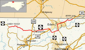
North Carolina Highway 770 (NC 770) is a 32-mile-long (51 km) state highway running through rural North Carolina and Eden. The road travels from NC 704 near Sandy Ridge to the Virginia state line southwest of Danville. NC 770 runs along a concurrency from Eden to the eastern terminus with U.S. Route 311 (US 311). Most of the road is two lanes wide. NC 770 is one of the few North Carolina state highways numbered in the 700s.
Route description
NC 770 begins at NC 704 near Sandy Ridge. The road begins to head to the east from the intersections along a two lane road. The road continues through a very rural area of Stokes County passing by many farms. The road curves around the foothills of North Carolina until reaching the Stoneville area. It crosses over the Mayo River and has an interchange with US 220 before entering downtown Stoneville. NC 770 passes through Stoneville along Main Street. After leaving Stoneville the road continues through rural Stokes County before reaching the community of Providence. Shortly before the highway enters Eden it turns to the left along a bypass that bypasses the downtown area of Eden to the south. NC 770 forms a concurrency with US 311 before they cross over the Dan River.[1]
The bypass is joined by NC 87 before the right-of-way ends at an intersection with NC 14 southeast of the city. The four roads travel together crossing the Dan River and enter a business district of eastern Eden. At an interchange with Meadow Road, NC 14 and NC 87 continue north while US 311 and NC 770 exit to head east on Meadow Road. At this point, NC 700 begins and travels along US 311 and NC 770 for just over one mile (1.6 km). They head northeast before making a sharp curve to the east at a factory to cross a railroad at-grade. The road soon begins to curve back to the north where NC 770 ends at the Virginia state line but US 311 continues another seven and a half miles (12.1 km) to Danville.[1]
History
NC 770 began in 1930 between US 311 in Stoneville and NC 54 in Leaksville. In 1933 NC 770 was extended east to the Virginia State Line via. the town of Draper. In 1934 the road was extended again to the west running along US 311 for a couple of miles and then continuing to NC 704. In 1966 the road was straightened to run directly into Stoneville. In 2000 the road was routed along its current routing around Eden.
Junction list
| County | Location | mi[1] | km | Destinations | Notes |
|---|---|---|---|---|---|
| Stokes | Sandy Ridge | 0.0 | 0.0 | Y intersection | |
| Rockingham | | 10.6– 10.7 | 17.1– 17.2 | Interchnage | |
| Eden | 18.5 | 29.8 | Western end of US 311 concurrency; eastern terminus of NC 135 | ||
| | 21.0 | 33.8 | Western end of NC 87 concurrency | ||
| | 22.7 | 36.5 | Western end of NC 14 concurrency | ||
| Eden | 25.0– 25.2 | 40.2– 40.6 | Interchange; eastern end of NC 14 / NC 87 concurrency; western end of NC 700 concurrency | ||
| 26.5 | 42.6 | Eastern end of NC 700 concurrency | |||
| | 32.3 | 52.0 | Virginia state line | ||
1.000 mi = 1.609 km; 1.000 km = 0.621 mi
| |||||
See also
- North Carolina Bicycle Route 4 - Concurrent with NC 770 from its western terminus to Simpson Street in Stoneville
References
- 1 2 3 4 Google (March 13, 2016). "North Carolina Highway 770" (Map). Google Maps. Google. Retrieved March 13, 2016.
External links
-
 Media related to North Carolina Highway 770 at Wikimedia Commons
 - NCRoads.com: N.C. 770