North Carolina Highway 150
| ||||
|---|---|---|---|---|
|
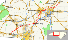
Route of NC 150 highlighted in red | ||||
| Route information | ||||
| Maintained by NCDOT | ||||
| Length: | 183.2 mi[1] (294.8 km) | |||
| Existed: | 1929 – present | |||
| Major junctions | ||||
| West end: |
| |||
| ||||
| East end: |
| |||
| Location | ||||
| Counties: | Cleveland, Gaston, Lincoln, Catawba, Iredell, Rowan, Davidson, Forsyth, Guilford, Rockingham, Caswell | |||
| Highway system | ||||
| ||||

North Carolina Highway 150 (NC 150) is a primary state highway in the state of North Carolina. It serves the Foothills and Piedmont Triad areas of the state, connecting the cities of Shelby, Mooresville, Salisbury and Winston-Salem.
Route description
NC 150 described from its eastern terminus to its western terminus:
Caswell, Rockingham, and Guilford counties
NC 150 travels west from its eastern terminus at U.S. Route 158 (US 158) in rural Caswell County on a winding two-lane road into Rockingham County. Shortly after crossing the county line, NC 150 has a short 1-mile-long (1.6 km) concurrency with NC 87 through the unincorporated community of Williamsburg. NC 150 exits the concurrency to the south, crossing into Guilford County shortly thereafter. After turning right at a junction with NC 61, the two-lane route continues through the small community of Monticello before coming to an interchange with Future Interstate 785 (I-785) and US 29.
Slowing to a 35 mph (56 km/h) speed limit after the interchange, NC 150 enters the heart of Browns Summit, the first of three northern Greensboro suburbs the route passes through. After passing through a small road kink at a railroad crossing in Browns Summit, the route makes its way out of town and into a rural area. As NC 150 approaches Summerfield (another suburb), numerous housing developments can be seen on either side of the road. The route passes through Summerfield's center, sharing a short 1.3-mile (2.1 km) concurrency with US 220 northbound, a stretch, which may be upgraded to Future I-73 in the future. Continuing west again, NC 150 enters the final Greensboro suburb of Oak Ridge, where it passes by the Oak Ridge Military Academy at its intersection with NC 68. NC 150 continues on a southwest course out of Oak Ridge and Guilford County.
Forsyth County

After Oak Ridge, NC 150 passes into Forsyth County on its way to Kernersville at the heart of the Piedmont Triad region. Entering the town from the northeast, NC 150 joins North Carolina Highway 66 through downtown. The NC 150 route switches onto the Business I-40/US 421 westbound freeway south of downtown. Continuing along the freeway, NC 150 crosses Salem Lake and enters the city of Winston-Salem. US 158 joins the concurrent routes for a short segment in downtown Winston-Salem, and exits at the Stratford Road interchange. NC 150 leaves the freeway at the Peters Creek Parkway exit. BB&T Ballpark is north of this interchange. Joining 4-lane Peters Creek Parkway southbound, NC 150 enters a commercial shopping district with numerous traffic signals. It passes by Marketplace Mall, crosses Silas Creek Parkway (NC 67), and has an interchange with I-40. NC 150 continues in a southbound direction, despite the route's east–west orientation, into Davidson County.
Davidson County
After leaving Winston-Salem and Forysth County, the numerous shopping centers that aligned the road are replaced by housing developments. NC 150 becomes a two-lane road again as the highway continues southward (signed west) through the community of Arcadia. The highway passes through an interchange with US 64 and continues into the communities of Reeds and Tyro. Near the Churchland community, NC 150 takes an odd turn east, despite being signed west, toward I-85/US 29/70/52 to avoid crossing the Yadkin River. At I-85, NC 150's routing becomes unusual. The westbound NC 150 roadway merges onto I-85 southbound lanes and the routes are concurrent for about 0.25 miles (0.40 km) before NC 150 left exits with US 29/70 southward. Northbound US 29/70 and eastbound NC 150 enters I-85 northbound on the left and the NC 150 exit ramp is immediately on the right. Since it is nearly impossible for one traveling on NC 150 northbound to exit there, motorists are directed to the next exit, Clark Road, which returns to the main roadway using TO NC 150 signs.
Rowan and Iredell counties
Continuing on westbound NC 150, the route crosses the Yadkin into Rowan County along with US 29/70 on Wil-Cox Bridge while a new bridge is built. The three conjoined highways continue together through downtown Spencer, passing Spencer Shops, and split in downtown Salisbury. NC 150 heads due west once again toward Mooresville, crossing into Iredell County.
Just outside Mooresville, NC 150 joins NC 152 for a short 0.25-mile (0.40 km) concurrency before splitting on a northern bypass route (Oak Ridge Farm Highway), skipping downtown Mooresville. After crossing NC 801 and NC 115, the highway enters a dense commercial shopping area along Plaza Drive. This stretch of road has witnessed massive growth in the early 2000s (decade) with the construction of numerous big box stores as a result of the growing popularity of nearby Lake Norman and the local NASCAR racing culture. As a consequence, NC 150 through western Mooresville was widened to a 4-lane boulevard in the early 2000s (decade). This developed area continues past NC 150's interchanges with US 21 and I-77. A few miles after crossing the Interstate, NC 150 returns to a two-lane road known as River Highway. The route enters the Lake Norman area, passing many businesses tailored to tourists, fishermen, and boating enthusiasts, before actually crossing the lake into Catawba County.
Catawba and Lincoln counties

Immediately after crossing the only bridge across Lake Norman, Marshall Steam Station is visible on the right. NC 150 continues past the power plant through the lake-oriented communities of Terrell and Sherrills Ford, crossing over numerous tributaries of the lake/Catawba River. Shortly after meeting NC 16 at a four-way intersection, NC 150 crosses into Lincoln County. In Lincolnton, NC 150 and NC 27 join together for a two-mile (3.2 km) segment through a commercial district, splitting shortly after an interchange with the US 321 freeway. Through the entire NC 27 concurrency, NC 150 is also concurrent with North Carolina Bicycle Route 6.[2] NC 150 continues southward, along with NC 155 and the business route of US 321, after the split east of downtown. Shortly outside the town, NC 150 splits from NC 155 and heads in a southwestly direction through Crouse and across the county line.
Gaston and Cleveland counties
In Gaston County, NC 150 travels through central Cherryville, North Carolina, where it meets NC 274. After crossing into Cleveland County, the route travels through Waco and across a small part of Kings Mountain Reservoir. Shortly after crossing NC 180, NC 150 enters Shelby, where it joins US 74 Business westbound. In downtown, NC 150 switches roads to share NC 18 south out of town. Two miles after crossing the mainline US 74, NC 150 and NC 18 split. NC 150 heads due west to Boiling Springs, where the route turns due south across the Broad River to end at the South Carolina state line. SC 150 continues south across the line toward I-85 again and Gaffney, South Carolina.
History
NC 150 was designated around 1929 as a spur route from the first NC 15, which is now mostly part of US 29. Its first routing ran west from Salisbury to Mooresville. By 1931, the route was extended through Lincolnton to US 74 in Shelby. The highway previously linking Lincolnton and Shelby was designated as NC 206.
NC 150's massive extension east occurred in late 1939 or 1940, giving the route its current eastern terminus at US 158 and western terminus at the South Carolina state line. It was partially cosigned in parts with US 29/70/52, US 74, NC 18, and old alignment of NC 184.
NC 150 underwent numerous realignments in the 1940s and 1950s in Winston-Salem with the construction of the new "parkways" (Silas Creek Parkway, Peters Creek Parkway, Corporation Parkway). Its alignment change in Kernersville, along with its extension along Peters Creek Parkway, occurred in 1994.
The segment of NC 150 through Mooresville was replaced with a northern bypass route in the late 1950s. In the 2000s (decade), NC 150 through Mooresville was widened to a four-lane boulevard, as was southern Peters Creek Parkway in southern Winston-Salem.
NC 150, once signed as North and South, was converted in 1982 to its current East and West signage and description.
Junction list
| County | Location | mi[1] | km | Destinations | Notes |
|---|---|---|---|---|---|
| Cleveland | State line | 0.0 | 0.0 | ||
| Boiling Springs | 5.4 | 8.7 | College Avenue – Cliffside | ||
| Shelby | 11.5 | 18.5 | South end of NC 18 Truck overlap | ||
| 13.7 | 22.0 | ||||
| 14.7 | 23.7 | West end of US 74 Bus. and north end of NC 18 Truck overlap | |||
| 16.2 | 26.1 | East end of US 74 Bus. overlap | |||
| 17.9 | 28.8 | To Cleveland County Fairgrounds | |||
| Gaston | Cherryville | 26.0 | 41.8 | ||
| 27.1 | 43.6 | ||||
| Lincoln | Roseland | 33.1 | 53.3 | West Highway 150 – Lincolnton | West end of NC 27 Truck overlap |
| Lincolnton | 35.5 | 57.1 | South end of US 321 Bus. overlap; diamond interchange | ||
| 37.2 | 59.9 | North end of US 321 Bus., west end of NC 27 and east end of NC 27 Truck overlap | |||
| 37.8 | 60.8 | Partial cloverleaf interchange | |||
| Boger City | 39.2 | 63.1 | East end of NC 27 overlap | ||
| Catawba | | 48.3 | 77.7 | Diamond interchange | |
| Killian Crossroads | 49.1 | 79.0 | |||
| Iredell | Mooresville | 61.8 | 99.5 | Diamond interchange; exit 36 | |
| 63.1 | 101.5 | Diamond interchange | |||
| 64.5 | 103.8 | West end of NC 152 Truck overlap | |||
| 64.9 | 104.4 | ||||
| 66.3 | 106.7 | ||||
| 67.7 | 109.0 | West end of NC 152 and east end of NC 152 Truck overlap | |||
| | 68.0 | 109.4 | East end of NC 152 overlap | ||
| Rowan | Salisbury | 84.6 | 136.2 | ||
| 86.7 | 139.5 | South end of US 29 and west end of US 70 overlap | |||
| 78.8 | 126.8 | Innes Street | |||
| Yadkin River | 92.6 | 149.0 | Bridge over Yadkin River | ||
| Davidson | | 93.0 | 149.7 | Permanently closed as of April, 2010; was exit 82[3][4][5][6] | |
| | 93.5 | 150.5 | Permanently closed as of May, 2013; was exit 83[3][5][6] | ||
| | 93.8 | 151.0 | North end of US 29 and east end of US 70 overlap; exit 84 | ||
| | 106.0 | 170.6 | Partial cloverleaf interchange | ||
| Forsyth | Winston-Salem | 121.5 | 195.5 | Clemmonsville Road | Double roundabout interchange |
| 123.0 | 197.9 | Trumpet interchange; exit 192 | |||
| 123.3 | 198.4 | ||||
| 124.9 | 201.0 | West end of I-40 Bus/US 158 and north end of US 421 overlap; exit 5A | |||
| 125.3 | 201.7 | Broad Street – BB&T Ballpark | Exit 5B | ||
| 125.6 | 202.1 | Cherry Street – Convention Center | Exit 5C | ||
| 125.7 | 202.3 | Main Street / First Street – Old Salem, Salem College | Exit 5D | ||
| 126.3 | 203.3 | Signed as exits 6A (south) and 6B (north) | |||
| 126.7 | 203.9 | Martin Luther King Jr. Drive | To Winston-Salem State University; exit 6C | ||
| 127.7 | 205.5 | Lowery Street / Fifth Street | Eastbound Lowery Street, westbound Fifth Street; exit 7 | ||
| 128.6 | 207.0 | East end of US 158 overlap; eastbound exit and westbound entrance; exit 8 | |||
| 130.4 | 209.9 | Linville Road | Exit 10 | ||
| Kernersville | Future interchange (under construction)[7] | ||||
| 134.5 | 216.5 | South Main Street | Exit 14 | ||
| 136.1 | 219.0 | East end of I-40 Bus and south end of US 421/NC 66 overlap; exit 15 | |||
| 137.0 | 220.5 | North end of NC 66 overlap | |||
| Guilford | Oak Ridge | 143.0 | 230.1 | ||
| Summerfield | Future interchange (under construction, to be completed by April 2017)[8] | ||||
| 148.7 | 239.3 | North end of US 220 overlap | |||
| 150.0 | 241.4 | South end of US 220 overlap | |||
| | 163.0 | 262.3 | Partial cloverleaf interchange | ||
| Osceola | 167.4 | 269.4 | |||
| Rockingham | Williamsburg | 171.6 | 276.2 | North end of NC 87 overlap | |
| | 172.7 | 277.9 | South end of NC 87 overlap | ||
| Caswell | | 183.2 | 294.8 | ||
1.000 mi = 1.609 km; 1.000 km = 0.621 mi
| |||||
Bannered routes
Lincolnton alternate route
| |
|---|---|
| Location: | Lincolnton, North Carolina |
| Length: | 3.9 mi[9] (6.3 km) |
| Existed: | 1956–1960 |
North Carolina Highway 150A (NC 150A) was established in 1956 when NC 150 was rerouted onto new primary routing bypassing southeast of downtown Lincolnton; the old alignment became NC 150A. The route followed West Highway 150 to Riverside Drive, where it linked-up with NC 27. In concurrency, it goes through downtown area via Main Street and Court Square Drive before linking back with NC 150 at Generals Boulevard. In 1960, NC 150A was decommissioned, leaving NC 27 through most of it and downgrade for West Highway 150 (SR 1407).
Mooresville alternate route
| |
|---|---|
| Location: | Mooresville, North Carolina |
| Length: | 1.6 mi[10] (2.6 km) |
| Existed: | 1953–1955 |
North Carolina Highway 150A (NC 150A) was established between 1950-1953 as a renumbering of NC 150 along McLand Street and Main Street through downtown Mooresville. Around 1955, NC 150 was completely removed from the downtown area and NC 150A was renumbered as NC 152.
References
- 1 2 Google (June 7, 2014). "North Carolina Highway 150" (Map). Google Maps. Google. Retrieved June 7, 2014.
- ↑ "NC 6 - Piedmont Spur". North Carolina Bike Routes Beta. Walk Bike North Carolina Bicycle Routes. Retrieved March 22, 2016.
- 1 2 "NCDOT: I-85 Corridor Improvement Project". Retrieved June 19, 2011.
- ↑ "SalisburyPost.com: Safety concerns lead to closing of Wil-Cox Bridge; no timeframe on reopening". Retrieved February 18, 2011.
- 1 2 "NC 150 Route Change (2012-03-01)" (PDF). North Carolina Department of Transportation. March 1, 2012. Retrieved May 26, 2013.
- 1 2 NC 150 Route Change (2012-01-04) (PDF) (Map). North Carolina Department of Transportation. January 4, 2012. Retrieved May 26, 2013.
- ↑ Staff. "Winston-Salem Northern Beltway". North Carolina Department of Transportation. Retrieved February 3, 2016.
- ↑ Project No. I-5110/R-2413, Guilford County, Future I-73 from SR 2085 (Joseph M. Bryan Blvd.) to Haw River, Map 5 of 5 (PDF) (Map). North Carolina Department of Transportation. Retrieved August 15, 2015.
- ↑ Google (June 7, 2014). "North Carolina Highway 150A - Lincolnton" (Map). Google Maps. Google. Retrieved June 7, 2014.
- ↑ Google (June 7, 2014). "North Carolina Highway 150A - Mooresville" (Map). Google Maps. Google. Retrieved June 7, 2014.
External links
-
 Media related to North Carolina Highway 150 at Wikimedia Commons
 - NCRoads.com: N.C. 150
- NCRoads.com: N.C. 150-A