Nieu-Bethesda
| Nieu-Bethesda | |
|---|---|
|
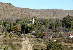
View of Nieu-Bethesda | |
 Nieu-Bethesda  Nieu-Bethesda  Nieu-Bethesda
| |
| Coordinates: 31°52′S 24°33′E / 31.867°S 24.550°ECoordinates: 31°52′S 24°33′E / 31.867°S 24.550°E | |
| Country | South Africa |
| Province | Eastern Cape |
| District | Sarah Baartman |
| Municipality | Dr Beyers Naudé |
| Established | 1875 |
| Government | |
| • Type | Ward 7 |
| • Councillor | Arthur Ronald Knottcraig |
| Area[1] | |
| • Total | 34.05 km2 (13.15 sq mi) |
| Population (2011)[1] | |
| • Total | 1,540 |
| • Density | 45/km2 (120/sq mi) |
| Racial makeup (2011)[1] | |
| • Black African | 25.1% |
| • Coloured | 65.2% |
| • Indian/Asian | 0.6% |
| • White | 8.7% |
| • Other | 0.5% |
| First languages (2011)[1] | |
| • Afrikaans | 92.0% |
| • English | 6.4% |
| • Xhosa | 1.0% |
| • Other | 0.6% |
Nieu-Bethesda (Dutch and Afrikaans for New Bethesda) is a village in the Eastern Cape at the foot of the Sneeuberge, approximately 50 kilometres (31 mi) from Graaff Reinet. It was founded in 1875 as a church town, like many other Karoo villages, and attained municipal status in 1886. The name is of biblical origin (John 5:2-4) and means "place of flowing water".[2]
Originally established as congregation of the Dutch Reformed Church on the farm Uitkyk in 1875, it became a municipality about 1886. It now falls within the Dr Beyers Naudé Local Municipality.
It is known for the Owl House, a museum dedicated to the eccentric artist Helen Martins, and the nearby Kompasberg, the highest point in the Eastern Cape province.
References
- 1 2 3 4 "Main Place Nieu-Bethesda". Census 2011.
- ↑ Raper, P. E. (1989). Dictionary of Southern African Place Names. Jonathan Ball Publishers. p. 332. ISBN 978-0-947464-04-2 – via Internet Archive.
External links
| Wikivoyage has a travel guide for Nieu-Bethesda. |
![]() Media related to Nieu-Bethesda at Wikimedia Commons
Media related to Nieu-Bethesda at Wikimedia Commons
Municipalities and communities of Sarah Baartman District Municipality, Eastern Cape | ||
|---|---|---|
District seat: Port Elizabeth | ||
| Blue Crane Route | .svg.png) | |
| Dr Beyers Naudé | ||
| Kouga | ||
| Kou-Kamma | ||
| Makana | ||
| Ndlambe | ||
| Sunday's River Valley | ||