Steytlerville
| Steytlerville | |
|---|---|
|
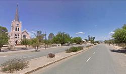
Steytlerville seen from Sarel Cilliers Street | |
 Steytlerville  Steytlerville  Steytlerville
| |
| Coordinates: 33°20′S 24°20′E / 33.333°S 24.333°ECoordinates: 33°20′S 24°20′E / 33.333°S 24.333°E | |
| Country | South Africa |
| Province | Eastern Cape |
| District | Sarah Baartman |
| Municipality | Dr Beyers Naudé |
| Established | 1875 |
| Area[1] | |
| • Total | 24.7 km2 (9.5 sq mi) |
| Population (2011)[1] | |
| • Total | 4,017 |
| • Density | 160/km2 (420/sq mi) |
| Racial makeup (2011)[1] | |
| • Black African | 22.8% |
| • Coloured | 71.1% |
| • Indian/Asian | 0.2% |
| • White | 5.3% |
| • Other | 0.7% |
| First languages (2011)[1] | |
| • Afrikaans | 80.1% |
| • Xhosa | 17.1% |
| • English | 1.4% |
| • Other | 1.4% |
| Postal code (street) | 6250 |
| PO box | 6250 |
| Area code | 049 |
Steytlerville is a settlement in Sarah Baartman District Municipality in the Eastern Cape province of South Africa.
Town on the Groot River, 164km north-west of Port Elizabeth and 90km east of Willowmore. It was founded in 1876 on the farm Doorspoort and attained municipal status in 1891. Named after the Reverend Abraham Isaac Steytler (1840-1922), minister of the Dutch Reformed Church, and Moderator of the Cape synod from 1909 to 1915.[2]
References
- 1 2 3 4 Sum of the Main Places Steytlerville and Vuyolwetho from Census 2011.
- ↑ "Dictionary of Southern African Place Names (Public Domain)". Human Science Research Council. p. 418.
| Wikimedia Commons has media related to Steytlerville. |
Municipalities and communities of Sarah Baartman District Municipality, Eastern Cape | ||
|---|---|---|
District seat: Port Elizabeth | ||
| Blue Crane Route | .svg.png) | |
| Dr Beyers Naudé | ||
| Kouga | ||
| Kou-Kamma | ||
| Makana | ||
| Ndlambe | ||
| Sunday's River Valley | ||
This article is issued from Wikipedia - version of the 9/5/2016. The text is available under the Creative Commons Attribution/Share Alike but additional terms may apply for the media files.