Newton Hamilton, Pennsylvania
| Newton Hamilton, Pennsylvania | |
|---|---|
| Borough | |
|
House on Water Street | |
 Newton Hamilton, Pennsylvania | |
| Coordinates: 40°23′34″N 77°50′06″W / 40.39278°N 77.83500°WCoordinates: 40°23′34″N 77°50′06″W / 40.39278°N 77.83500°W | |
| Country | United States |
| State | Pennsylvania |
| County | Mifflin |
| Settled | 1802 |
| Incorporated | 1843 |
| Government | |
| • Type | Borough Council |
| • President | Carl Sunderland |
| • Councilman | John Woods |
| • Councilman | Thomas White |
| • Councilman | Roger Howey |
| • Councilman | Kenneth Renninger |
| Area | |
| • Total | 0.2 sq mi (0.5 km2) |
| Population (2000) | |
| • Total | 272 |
| • Density | 1,624.1/sq mi (617.8/km2) |
| Time zone | Eastern (EST) (UTC-5) |
| • Summer (DST) | EDT (UTC-4) |
| Zip code | 17075 |
| Area code(s) | 814 |
| School district: | Mount Union Area School District |
| Local phone exchanges: 542, 543 | |
_stone_house.jpg)
Newton Hamilton is a borough (established April 12, 1843) in Mifflin County, Pennsylvania, United States. The population was 272 at the 2000 census.
Geography
Newton Hamilton is located at 40°23′34″N 77°50′6″W / 40.39278°N 77.83500°W (40.392831, -77.835081).[1]
According to the United States Census Bureau, the borough has a total area of 0.2 square miles (0.52 km2), of which, 0.2 square miles (0.52 km2) of it is land and 0.04 square miles (0.10 km2) of it (10.53%) is water.
Demographics
| Historical population | |||
|---|---|---|---|
| Census | Pop. | %± | |
| 1850 | 353 | — | |
| 1860 | 306 | −13.3% | |
| 1870 | 350 | 14.4% | |
| 1880 | 317 | −9.4% | |
| 1890 | 333 | 5.0% | |
| 1900 | 384 | 15.3% | |
| 1910 | 340 | −11.5% | |
| 1920 | 400 | 17.6% | |
| 1930 | 348 | −13.0% | |
| 1940 | 395 | 13.5% | |
| 1950 | 397 | 0.5% | |
| 1960 | 338 | −14.9% | |
| 1970 | 280 | −17.2% | |
| 1980 | 317 | 13.2% | |
| 1990 | 287 | −9.5% | |
| 2000 | 272 | −5.2% | |
| 2010 | 205 | −24.6% | |
| Est. 2015 | 204 | [2] | −0.5% |
| Sources:[3][4][5] | |||
As of the census[4] of 2000, there were 272 people, 99 households, and 79 families residing in the borough. The population density was 1,624.1 people per square mile (617.8/km2). There were 114 housing units at an average density of 680.7 per square mile (258.9/km2). The racial makeup of the borough was 98.90% White, 0.37% from other races, and 0.74% from two or more races. Hispanic or Latino of any race were 0.37% of the population.
There were 99 households, out of which 43.4% had children under the age of 18 living with them, 60.6% were married couples living together, 11.1% had a female householder with no husband present, and 20.2% were non-families. 18.2% of all households were made up of individuals, and 11.1% had someone living alone who was 65 years of age or older. The average household size was 2.75 and the average family size was 3.04.
_ME_Church_1881.jpg)
In the borough the population was spread out, with 30.5% under the age of 18, 8.8% from 18 to 24, 27.6% from 25 to 44, 21.3% from 45 to 64, and 11.8% who were 65 years of age or older. The median age was 32 years. For every 100 females there were 88.9 males. For every 100 females age 18 and over, there were 90.9 males.
The median income for a household in the borough was $30,357, and the median income for a family was $32,500. Males had a median income of $29,286 versus $25,625 for females. The per capita income for the borough was $11,584. About 6.0% of families and 8.1% of the population were below the poverty line, including none of those under the age of eighteen and 24.2% of those sixty five or over.
References
- ↑ "US Gazetteer files: 2010, 2000, and 1990". United States Census Bureau. 2011-02-12. Retrieved 2011-04-23.
- ↑ "Annual Estimates of the Resident Population for Incorporated Places: April 1, 2010 to July 1, 2015". Retrieved July 2, 2016.
- ↑ "Census of Population and Housing". U.S. Census Bureau. Retrieved 11 December 2013.
- 1 2 "American FactFinder". United States Census Bureau. Retrieved 2008-01-31.
- ↑ "Incorporated Places and Minor Civil Divisions Datasets: Subcounty Resident Population Estimates: April 1, 2010 to July 1, 2012". Population Estimates. U.S. Census Bureau. Retrieved 11 December 2013.
Municipalities and communities of Mifflin County, Pennsylvania, United States | ||
|---|---|---|
| Boroughs | 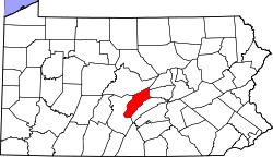 | |
| Townships | ||
| CDPs | ||
| Unincorporated community | ||