Newfoundland and Labrador Route 340
| ||||
|---|---|---|---|---|
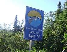
| Road to the Isles | ||||
 | ||||
| Route information | ||||
| Length: | 106 km[1] (66 mi) | |||
| Major junctions | ||||
| South end: |
Route 1 (Trans-Canada Highway) near Lewisporte | |||
|
Route 342 in Lewisporte | ||||
| North end: |
Long Point Lighthouse near Crow Head, Twillingate | |||
| Highway system | ||||
|
Highways in Newfoundland and Labrador
| ||||


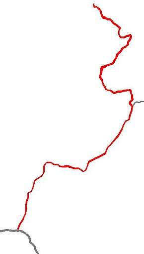
Route 340 (also known as Road to the Isles) is a road in the Canadian province of Newfoundland and Labrador that runs from Notre Dame Junction to Long Point Lighthouse, passing through the towns of Lewisporte, Summerford, Twillingate, and other smaller communities.[1]
The highway has a length of 106 kilometres[1] and a speed limit in the range of 40–80 km/h depending on whether the road is passing through a settlement.
As the route's alternate name implies, the Road to the Isles passes through several islands off the coast of the main island of Newfoundland, such as New World Island, Twillingate Islands, and some uninhabited islands. Change Islands and Fogo Island are accessible by ferry via Route 331, which has a junction with Route 340.[2]
Route 340 is important in that it is the only road connection that New World Island and Twillingate Islands have with the main island.[1][3]
Route description
Route 340 begins at Notre Dame Junction, which is a nickname given to the route's interchange with Route 1 (the Trans-Canada Highway).[4] Leading northward, the route passes through the town of Lewisporte, where it then continues by turning right at an intersection with Route 342.[1] The MV Sir Robert Bond, a ferry leading to the towns of Cartwright and Happy Valley-Goose Bay in Labrador, is accessible 3.7 km (2.3 mi) north of Route 340 in Lewisporte via Route 342.[5][6]
The route continues northeastward and passes through the shoreline communities of Michael's Harbour[3] and Campbellton, where the route intersects Route 343. Continuing northeastward, the route also intersects Route 331. This route leads to ferries connecting Change Islands and Fogo Island with the main island.[2]
Route 340 then passes through the community of Boyd's Cove.[1] Afterwards, the route leads northward through a series of causeways that connect the main island of Newfoundland with New World Island. While on New World Island, the route passes through the town of Summerford and intersects Route 344. Following that intersection, the route leads northward until passing through Virgin Arm, where it then intersects Route 345 and leads northeastward. It then passes through the communities of Fairbanks, Hillgrade, and Newville.[1][3]
1.5 km north of Newville, the route intersects Route 346 and then veers westward towards a causeway connecting New World Island to Twillingate Islands. After the causeway, the route immediately veers northward and passes through Purcell's Harbour and Little Harbour, where the route then veers northwestward.[1][3]
The route then passes through the town of Twillingate, where a left turn at a local intersection is required to remain on the route. Through the town, the route is largely residential and is called Main Street. After a small loop, the route leads northwestward through Tickle Bridge and continues through Twillingate. The road then passes through Wild Cove and then Crow Head, where a sharp right turn is required to remain on Route 340. The final stretch leads northward to Long Point Lighthouse, located at the edge of the Atlantic Ocean.[1]
List of Communities along route

In order from the Trans-Canada Highway exit to the end at Twillingate, including communities accessible by another short highway that branches off from Route 340, with towns of 500 or more people in bold:
- Lewisporte
- Embree (accessible by driving through Lewisporte)
- Little Burnt Bay (accessible by driving through Lewisporte)
- Michael's Harbour
- Campbellton
- Comfort Cove-Newstead
- Baytona
- Birchy Bay
- Gander Bay (exit to route 330 in Boyd's Cove)
- Boyd's Cove
- Summerford
- Cottlesville (exit in Summerford)
- Virgin Arm
- Moreton's Harbour (exit in Virgin Arm)
- Tizzard's Harbour (exit in Virgin Arm)
- Fairbanks
- Hillgrade
- Newville
- Cobb's Arm (exit around Newville)
- Pike's Arm (exit around Newville)
- Toogood Arm (exit around Newville)
- Herring Neck (exit around Indian Cove)
- Salt Harbour (through Herring Neck)
- Indian Cove
- Black Duck Cove (exit 1 on Twillingate Island)
- Kettle Cove (exit 2 on Twillingate Island)
- Bayview (exit 2 on Twillingate Island)
- Purcell's Harbour (exits 3 and 4 on Twillingate Island)
- Little Harbour (exits 5 and 6 on Twillingate Island)
- Twillingate
- Crow Head (left turn at Main Street-Toulinguet Street intersection in Twillingate)
- Durrell (right turn at Main Street-Toulinguet Street intersection in Twillingate)
References
- 1 2 3 4 5 6 7 8 9 Overview Map of NL 340 (Map). Google Maps. Retrieved 2008-06-29.
- 1 2 Overview Map of Road Connection from NL 340 to Change Islands and Fogo Island Ferries (Map). Google Maps. Retrieved 2008-07-20.
- 1 2 3 4 Map showing Twillingate Islands, New World Island (NWI), and south of NWI (Map). WikiMapia. Retrieved 2008-06-28.
- ↑ The Kittiwake Coast - The Road to the Isles | Iceberg Finder | Find icebergs in Newfoundland and Labrador
- ↑ Overview Map of Road Connection from NL 340 to Labrador Ferry (Map). Google Maps. Retrieved 2008-07-20.
- ↑ Government of Newfoundland and Labrador - Canada - Provincial Ferry Services - Goose Bay-Cartwright-Lewisporte