Newark–Elizabeth Rail Link
| Newark-Elizabeth Rail Link | |||
|---|---|---|---|
| Technical | |||
| Line length | 8.8 mi (14.2 km) | ||
| Track gauge | 1,435 mm (4 ft 8 1⁄2 in) | ||
| |||
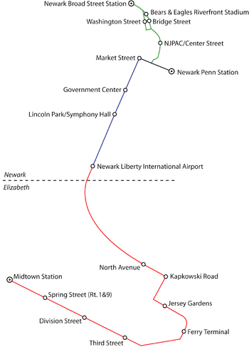
The Newark–Elizabeth Rail Link was a proposed 8.8-mile (14.2 km)-long light rail line in New Jersey, which would have connected the downtown areas of Newark and Elizabeth with Newark Liberty International Airport and been operated by New Jersey Transit. The construction of the project was being planned in stages, or "minimum operable segments" (MOS).
The first minimum operable segment (MOS-1) opened to the public on July 17, 2006, as the Newark Light Rail Broad Street Line, connecting Broad Street Station and Penn Station in Newark.[1]
The second segment (MOS-2) would have connected Penn Station with the airport, while the third segment became known as the Union County Light Rail.
New Jersey Transit has since removed further segments from their list of candidate projects for their Capital Improvement Program, effectively ending any further construction.
Station listing
MOS-2
- Newark Penn Station
- Market Street (at Mulberry Street)
- Government Center (Mulberry Street)
- Lincoln Park/Symphony Hall (Camp Street)
- Newark Liberty International Airport (connecting with the airport via AirTrain Newark)
Liberty Corridor Bus Rapid Transit Service
The planned Liberty Corridor Bus Rapid Transit Service which include the Greater Newark go bus and the Union go bus expressway, will provide service along much of the route of the NERL.[2]
References
- ↑ NJ TRANSIT Department of Capital Planning and Programs (August 2006). "New Jersey Transit: Newark City Subway (NCS) Extension to Newark Broad Street Station". NJ Transit. Archived from the original on 2009-06-17. Retrieved 2015-09-07.
- ↑ "Liberty Corridor Bus Rapid Transit Service". NJDOT. Retrieved 2012-03-03.
| Operating | ||
|---|---|---|
| Planned | ||
| Unbuilt | ||