New York TRACON
The New York Terminal Radar Approach Control (TRACON) is located in Westbury, New York. New York TRACON, also known as N90, is a consolidated TRACON meaning that a single location provides approach service for several large airports.
The primary responsibility of the New York TRACON is the safe, orderly, and expeditious flow of arrival, departure, and en-route traffic. N90 is responsible for three major airports, all located within the same New York Class B airspace: John F. Kennedy International Airport, Newark Liberty International Airport, and LaGuardia Airport. Additionally, N90 is responsible for dozens of smaller but busy fields, including Long Island MacArthur Airport, Teterboro Airport, Tweed New Haven Regional Airport, and Republic Airport. N90 also controls the large number of VFR aircraft that fly through the New York Class B airspace every day.
The New York TRACON is a Level 12 facility and one of seven "Large TRACONs" currently existing throughout the United States. The others include the Atlanta Large TRACON (A80), the Boston Consolidated TRACON (A90), the Potomac Consolidated TRACON (PCT), the Southern California TRACON (SCT), the Dallas/Fort Worth TRACON (D10), and the Northern California TRACON (NCT).
Unlike smaller TRACONs which only utilize one radar, the New York TRACON uses many different airport surveillance radar (ASR) sites, including:
- Newark (EWR)
- White Plains (HPN)
- MacArthur (ISP)
- Kennedy (JFK)
- Stewart (SWF)
Area breakdown
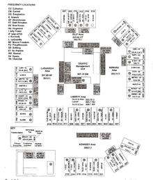
The New York TRACON is divided into 5 areas. Sectors, along with their frequencies and radio sites, are given below.
LaGuardia Area
The LaGuardia area of the TRACON controls LaGuardia Airport and two of the higher-traffic volume satellites, Danbury Municipal Airport and Westchester County Airport.
- EMPYR (1D): 127.3 at EWR, backup at Mount Freedom
- HAARP (1V): 120.8 at LGA, backup at Douglaston
- LGA Departure (1L): 120.4 at LGA, backup at Douglaston
- LGA Final Vector (1F): 134.9 at JFK, backup at LGA
- NOBBI (1X): 126.4 at HPN
- NYACK (1Y): 120.55 at HPN
- Military (UHF): 257.65 at HPN and 263.0 at LGA
Kennedy Area
The Kennedy area controls John F. Kennedy International Airport and its only major satellite, Republic Airport. This area controls many international flights from Europe because Kennedy is known in the aviation community as the "Gateway to America".[1]
- CAMRN (2G): 128.125 at JFK, backup at Douglaston
- ILS Monitor 1 (2O): 119.1 at JFK
- ILS Monitor 2 (2T): 123.9 at JFK
- JFK Departure (2J): 135.9 at JFK, backup at Douglaston
- JFK Final Vector (2A): 132.4 at JFK
- JFK Satellite (2S): 118.4 at JFK
- ROBER (2K): 125.7 at JFK, backup at Douglaston
- Military (UHF): 269.0 at JFK
Islip area
The Islip area controls all low altitude flights along Long Island in addition to Long Island MacArthur Airport.
- BEADS (3B): 125.975 at HTO, backup at ISP AFSS
- BEADS Low (3N): 118.95 at HTO
- CCC (Calverton) (3E): 118.0 at ISP, backup at ISP AFSS
- ISP (3H): 120.05 at ISP
- LOVES (3I): 124.075 at HVN, backup at Douglaston
- SEALL (3R): 133.1 at N90
- VIKKY (3Z): 128.625 at CCC
- Military (UHF): 343.65 at HTO and 343.75 at ISP
Newark Area
The Newark area of the TRACON covers Newark Liberty International Airport along with the majority of the TRACON's satellite airports including Teterboro Airport, Morristown Municipal Airport, and Caldwell/Essex County Airport.
- ARD (Yardley) (4P): 128.55 at EWR, backup at St. Francis
- EWR Departure (4N): 119.2 at EWR, backup at St. Francis
- EWR Final Vector 4 (4Q): 125.5 at EWR
- EWR Final Vector 22 (4M): 125.5 at EWR
- EWR Satellite (4E): 126.7 at EWR
- METRO (4H): 132.8 at SBJ
- MUGZY (4U): 127.6, EWR at backup at Mount Freedom
- North Arrival (4A): 120.15 at EWR
- ZEEBO (4S): 123.775 at SAX
- Military (UHF): 353.75 at EWR
Liberty Area
The Liberty area's role is for high altitude departure control for all sectors. The Catskill position has responsibility for numerous satellites to the north of the NY TRACON airspace. Three of the higher-traffic volume satellites are Stewart International Airport, Orange County Airport, and Dutchess County Airport.
- Catskill (5H): 132.75 at SWF
- East (56): 126.8 at CMK, backup at POU
- “LIBBU” (59): 135.65 at SWF
- North (52): 118.175 at LGA, backup at JFK
- South (58): 124.75 at EWR, backup at Mount Freedom
- West (54): 120.85 at EWR, backup at SBJ
- Military (UHF): South and West, 353.75 at JFK; Catskill, 363.1 at HUO; North and East, 268.7 at SWF