New York State Route 9P
| ||||
|---|---|---|---|---|
|
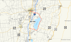
Map of Saratoga County in eastern New York with NY 9P highlighted in red | ||||
| Route information | ||||
| Auxiliary route of US 9 | ||||
| Maintained by NYSDOT and the city of Saratoga Springs | ||||
| Length: | 12.13 mi[1] (19.52 km) | |||
| Existed: | c. 1936[2][3] – present | |||
| Major junctions | ||||
| South end: |
| |||
|
| ||||
| North end: |
| |||
| Location | ||||
| Counties: | Saratoga | |||
| Highway system | ||||
| ||||

New York State Route 9P (NY 9P) is a state highway in central Saratoga County, New York, in the United States. It is an alternate route off U.S. Route 9 between Malta and Saratoga Springs that connects US 9 to the eastern shore of Saratoga Lake. NY 9P meets NY 423 in the town of Stillwater and Interstate 87 in Saratoga Springs. In its final mile, NY 9P serves the Saratoga Race Course.
Route description
NY 9P begins at an intersection with US 9 in Malta. NY 9P proceeds eastward from US 9 as a two-lane residential street through Malta, passing the Bass Manor Museum. The route bends northeastward and soon southward along the shore of Saratoga Lake. At Saratoga Lake, NY 9P intersects with CR 108 (Plains Road) before heading southeast and away from the shore. As the route makes a bend to the north, CR 76 (Lake Road) intersects near the Saratoga Lake Golf Course. At this point, NY 9P becomes a lakeside highway on the eastern side of the lake, passing a long stretch of residences and an intersection with NY 423. After NY 423, NY 9P bends northeastward alongside the lake, now in the town of Stillwater and soon the town of Saratoga.[4]

North of the hamlet of Maple Shade, NY 9P intersects with the western terminus of CR 71 (Cedars Bluff Road). Along the lakeside, NY 9P bends westward, soon bending away from the lake at Point Breeze, where the road crosses over the northern end of the lake on the Saratoga County Veterans Memorial Bridge,[4] which was reconstructed in 2011.[5] From this point to Circular Street, NY 9P is named Union Avenue. Past the lake, NY 9P enters the city of Saratoga Springs, where it intersects the terminus of CR 22 (Crescent Avenue) and CR 66 (Dyer Switch Road). NY 9P turns to the northwest, passing the Saratoga National Golf Club before the terminus of CR 65 (Meadowbrook Road). Turning westward, NY 9P enters interchange 14 with the Adirondack Northway (I-87) and passing Yaddo Gardens. After the gardens, the route passes the Saratoga Race Course and enters a section of downtown Saratoga Springs designated as the Union Avenue Historic District.[4]
Within the historic district, NY 9P serves a number of stately Victorian homes built in the second half of the 19th and early 20th centuries, as well as buildings owned by Empire State College, some of which were once Skidmore College Buildings.[6] Union Avenue terminates at Circular Street, which abuts the eastern border of Congress Park. From here, NY 9P continues north on Circular Street before turning west on Spring Street a short distance after. The route continues along the north side of Congress Park for three blocks before ending at an intersection with US 9 and NY 50 (Broadway).[4]
History
An alternate route of U.S. Route 9 between Malta and Saratoga Springs by way of the eastern shore of Saratoga Lake was originally assigned NY 9X c. 1931.[7][8] In December 1934, an alternate route of US 9 in New York City was designated as U.S. Route 9X.[9] The alphanumerical duplication between the two routes was eliminated c. 1936 when NY 9X was redesignated as NY 9P.[2][3]
Major intersections
The entire route is in Saratoga County.
| Location | mi[1] | km | Destinations | Notes | |
|---|---|---|---|---|---|
| Malta | 0.00 | 0.00 | |||
| Town of Stillwater | 4.10 | 6.60 | Western terminus of NY 423 | ||
| Saratoga Springs | 10.15 | 16.33 | Exit 14 (I-87) | ||
| 12.13 | 19.52 | ||||
| 1.000 mi = 1.609 km; 1.000 km = 0.621 mi | |||||
See also
.svg.png) New York Roads portal
New York Roads portal
References
- 1 2 "2008 Traffic Volume Report for New York State" (PDF). New York State Department of Transportation. June 16, 2009. p. 30. Retrieved January 31, 2010.
- 1 2 Road Map & Historical Guide – New York (Map). Cartography by Rand McNally and Company. Sun Oil Company. 1935.
- 1 2 New York (Map). Cartography by General Drafting. Standard Oil Company. 1936.
- 1 2 3 4 Microsoft; Nokia (April 19, 2012). "overview map of NY 9P" (Map). Bing Maps. Microsoft. Retrieved April 19, 2012.
- ↑ "Route 9P bridge over Saratoga Lake now officially named Saratoga County Veterans Memorial Bridge". The Saratogian. July 4, 2012. Retrieved August 1, 2012.
- ↑ Template:Skidmore History
- ↑ Road Map of New York (Map). Cartography by General Drafting. Standard Oil Company of New York. 1930.
- ↑ New York (Map). Cartography by H.M. Gousha Company. Kendall Refining Company. 1931.
- ↑ "Mark Ways in the City". The New York Times. December 16, 1934.
External links
| Wikimedia Commons has media related to New York State Route 9P. |
- New York State Route 9P at New York Routes • New York State Highway Termini