New Mexico State Road 518
| ||||
|---|---|---|---|---|
| Route information | ||||
| Maintained by NMDOT | ||||
| Length: | 72.9 mi[1] (117.3 km) | |||
| Tourist routes: | Part of High Road to Taos Scenic Byway between NM 75 and NM 68 | |||
| Major junctions | ||||
| South end: | Mills Ave. in Las Vegas | |||
| North end: |
| |||
| Location | ||||
| Counties: | San Miguel, Mora, Taos | |||
| Highway system | ||||
| ||||

State Road 518 is a 72.9 mi (117.3 km) long state highway in northern New Mexico. NM 518 begins in the south near Interstate 25 in Las Vegas and proceeds north to La Cueva where the road turns northwest at its junction with New Mexico State Road 442. The road continues northwest through Mora and eventually ends at Ranchos de Taos where the road meets New Mexico State Road 68. The segment of NM 518 between Mora and Ranchos de Taos passes through the rugged terrain of the Sangre de Cristo Mountains and provides access to Carson National Forest where camping, fishing, skiing, and other recreational opportunities are available.
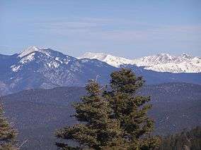
Telephoto view of the high Sangre de Cristo Range from the overlook between mileposts 60 and 61, on US Hill, February 2007.
See also
 U.S. Roads portal
 New Mexico portal
References
- ↑ "NMDOT State Routes" (PDF). New Mexico Department of Transportation. Retrieved 2008-03-26.
External links
![]() Geographic data related to New Mexico State Road 518 at OpenStreetMap
Geographic data related to New Mexico State Road 518 at OpenStreetMap
This article is issued from Wikipedia - version of the 10/28/2014. The text is available under the Creative Commons Attribution/Share Alike but additional terms may apply for the media files.