Sangre de Cristo Range
| Sangre de Cristo Range | |
|---|---|
| Northern Sangre de Cristo Mountains | |
|
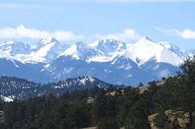
Sangre de Cristo Range seen from Hardscrabble Pass. | |
| Highest point | |
| Peak | Blanca Peak |
| Elevation | 14,345 ft (4,372 m) |
| Coordinates | 37°34′38″N 105°29′7″W / 37.57722°N 105.48528°WCoordinates: 37°34′38″N 105°29′7″W / 37.57722°N 105.48528°W |
| Dimensions | |
| Length | 75 mi (121 km) north-south |
| Width | 48 mi (77 km) east-west |
| Area | 1,250 sq mi (3,200 km2) |
| Naming | |
| Etymology | Sangre de Cristo Spanish: Blood of Christ |
| Geography | |
| Country | United States |
| State | Colorado |
| County | |
| Parent range | Sangre de Cristo Mountains |
| Borders on | San Luis Valley and Arkansas River watershed |
| Geology | |
| Orogeny | Fault-block mountains |
| Age of rock | Precambrian and Permian-Pennsylvanian |
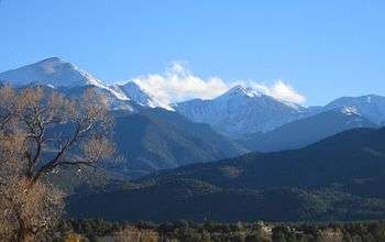
The Sangre de Cristo Range, called the East Range locally in the San Luis Valley, is a high, rugged and narrow mountain range of the Rocky Mountains in southern Colorado in the United States, running north and south along the east side of the Rio Grande Rift . The mountains extend southeast from Poncha Pass for about 75 miles (120 km) through south-central Colorado to La Veta Pass, approximately 20 miles (32 km) west of Walsenburg, and form a high ridge separating the San Luis Valley on the west from the watershed of the Arkansas River on the east. The Sangre de Cristo Range rises over 7,000 feet above the valleys and plains to the west and northeast.
According to the USGS, the range is the northern part of the larger Sangre de Cristo Mountains, which extend through northern New Mexico. Usage of the terms "Sangre de Cristo Range" and "Sangre de Cristo Mountains" is varied; however, this article discusses only the mountains between Poncha Pass and La Veta Pass.
Notable peaks
| Peak name | Elevation | Prominence |
|---|---|---|
| Blanca Peak [1] | 14,351 ft (4,374 m) | 5,326 ft (1,623 m) |
| Crestone Peak [2] | 14,300 ft (4,400 m) | 4,534 ft (1,382 m) |
| Crestone Needle [3] | 14,197 ft (4,327 m) | 437 ft (133 m) |
| Kit Carson Peak [4] | 14,165 ft (4,317 m) | 1,005 ft (306 m) |
| Challenger Point [5] | 14,080 ft (4,290 m) | 281 ft (86 m) |
| Humboldt Peak [6] | 14,064 ft (4,287 m) | 1,164 ft (355 m) |
| Ellingwood Point [7] | 14,042 ft (4,280 m) | 322 ft (98 m) |
| Mount Lindsey [8] | 14,042 ft (4,280 m) | 1,522 ft (464 m) |
| Little Bear Peak [9] | 14,037 ft (4,278 m) | 357 ft (109 m) |
| Columbia Point [10] | 13,960 ft (4,260 m) | 320 ft (98 m) |
| Mount Adams [11] | 13,937 ft (4,248 m) | 851 ft (259 m) |
| California Peak [12] | 13,855 ft (4,223 m) | 609 ft (186 m) |
| Rito Alto Peak [13] | 13,800 ft (4,200 m) | 1,114 ft (340 m) |
| Colony Baldy [14] | 13,711 ft (4,179 m) | 905 ft (276 m) |
| Pico Aislado [15] | 13,612 ft (4,149 m) | 837 ft (255 m) |
| Tijeras Peak [16] | 13,610 ft (4,150 m) | 724 ft (221 m) |
| Electric Peak [17] | 13,601 ft (4,146 m) | 915 ft (279 m) |
| Cottonwood Peak [18] | 13,504 ft (4,116 m) | 1,108 ft (338 m) |
| Twin Peaks [19] | 13,560 ft (4,130 m) | 600 ft (180 m) |
| Broken Hand Peak [20] | 13,579 ft (4,139 m) | 653 ft (199 m) |
| Fluted Peak [21] | 13,560 ft (4,130 m) | 714 ft (218 m) |
| Milwaukee Peak [22] | 13,528 ft (4,123 m) | 282 ft (86 m) |
Geography

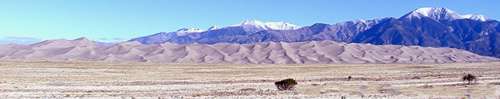
Most of the range is shared by two National Forests, which abut along the range divide. Most of the northeast (Arkansas River) side is located within the San Isabel National Forest, while most of the southwest (San Luis Valley) side is included in the Rio Grande National Forest. The central part of the range is designated as the Sangre de Cristo Wilderness. The Great Sand Dunes National Park sits on the southwestern flank of the range at the edge of the San Luis Valley. The range divide is traversed by no paved roads, only by four wheel drive and foot trails over Hayden Pass, Hermit Pass, Music Pass, Medano Pass, and Mosca Pass.
The highest peak in the range, located in the south, is Blanca Peak (14,345 feet/4,372 m); it is flanked by three other fourteeners: Little Bear Peak, Mount Lindsey, and Ellingwood Point.[23] Other well-known peaks are the fourteeners of the Crestone group: Kit Carson Mountain, Crestone Peak, Crestone Needle, and Humboldt Peak. Two sub-peaks of Kit Carson Mountain, Challenger Point and Columbia Point, are named in memory of the crews of the Space Shuttle Challenger and the Space Shuttle Columbia. The range is also home to many high peaks in the 13,000 to 14,000 foot (3,900-4,300 m) range. See the Sangre de Cristo Mountains article for other noteworthy summits in the greater range.
History and economy
In 1719 the Spanish explorer Antonio Valverde y Cosio named the Sangre de Cristo ("Blood of Christ") mountains after being impressed by the reddish hue of the snowy peaks at sunrise, alpenglow. Today tourism is the main economic activity.
Geology
The Sangre de Cristos are fault-block mountains similar to the Teton Range in Wyoming and the Wasatch Range in Utah. There are major fault lines running along both the east and west sides of the range and, in places, cutting through the range. Like all fault block mountain ranges the Sangre de Cristo's lack foothills which means the highest peaks rise abruptly from the valleys to the east and west, rising 7,000 feet in only a few miles in some places. The mountains were pushed up around 5 million years ago, basically as one large mass of rock. The Sangre de Cristo range is still being uplifted today as faults in the area remain active.
On the west side is the San Luis Valley, a portion of the Rio Grande Rift. On the southeast side is the Raton Basin, a quiet but still active volcanic field. On the northeast side are the Wet Mountains and the Front Range, areas of Precambrian igneous and metamorphic rocks formed during the Colorado orogeny some 1.7 billion years ago and then uplifted more recently during the Laramide orogeny.
The Blanca Massif is also Precambrian rock, while most of the rest of the Sangres is composed of younger Permian-Pennsylvanian (about 250-million-year-old) rock, a mix of sedimentary conglomerates, shales, and igneous intrusions. These sedimentary rocks originated as sediment eroded from the Ancestral Rocky Mountains.
See also
References
- ↑ "Blanca Peak". Peakbagger.com. Retrieved 2012-01-01.
- ↑ "Crestone Peak". Peakbagger.com. Retrieved 2012-01-01.
- ↑ "Crestone Needle". Peakbagger.com. Retrieved 2012-01-01.
- ↑ "Kit Carson Mountain". Peakbagger.com. Retrieved 2012-01-01.
- ↑ "Challenger Point". Peakbagger.com. Retrieved 2012-01-01.
- ↑ "Humboldt Peak". Peakbagger.com. Retrieved 2012-01-01.
- ↑ "Ellingwood Point". Peakbagger.com. Retrieved 2012-01-01.
- ↑ "Mount Lindsey". Peakbagger.com. Retrieved 2012-01-01.
- ↑ "Little Bear Peak". Peakbagger.com. Retrieved 2012-01-01.
- ↑ "Columbia Point". Peakbagger.com. Retrieved 2012-01-01.
- ↑ "Mount Adams". Peakbagger.com. Retrieved 2012-01-01.
- ↑ "California Peak". Peakbagger.com. Retrieved 2012-01-01.
- ↑ "Rito Alto Peak". Peakbagger.com. Retrieved 2012-01-01.
- ↑ "Colony Baldy". Peakbagger.com. Retrieved 2012-01-01.
- ↑ "Pico Aislado". bivouac.com. Retrieved 2012-01-01.
- ↑ "Tijeras Peak". Peakbagger.com. Retrieved 2012-01-01.
- ↑ "Electric Peak". Peakbagger.com. Retrieved 2012-01-01.
- ↑ "Cottonwood Peak". Peakbagger.com. Retrieved 2012-01-01.
- ↑ "Twin Peaks". Peakbagger.com. Retrieved 2012-01-01.
- ↑ "Broken Hand Peak". Peakbagger.com. Retrieved 2012-01-01.
- ↑ "Fluted Peak". Peakbagger.com. Retrieved 2012-01-01.
- ↑ "Milwaukee Peak". Peakbagger.com. Retrieved 2012-01-01.
- ↑ Ellingwood Point is not always counted as an official fourteener, as it has a high saddle connecting it with Blanca Peak, and hence a low topographic prominence.
External links
| Wikimedia Commons has media related to Sangre de Cristo Range. |
- Sangre de Cristo Range @ Peakbagger
- Table listing of all the thirteeners in Sangre de Cristo @ Pikes Peak Photo
- High resolution zoomable panorama of the Sangre de Cristo mountain range looking West
- CO & NM Sangre de Cristo Mountains
