New Hampshire Route 97
| ||||
|---|---|---|---|---|
|
Map of Rockingham County in southeastern New Hampshire with NH 97 highlighted in red | ||||
| Route information | ||||
| Maintained by NHDOT | ||||
| Length: | 2.563 mi[1] (4.125 km) | |||
| Major junctions | ||||
| West end: |
| |||
| East end: |
| |||
| Location | ||||
| Counties: | Rockingham | |||
| Highway system | ||||
| ||||

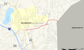
New Hampshire Route 97 (abbreviated NH 97) is a 2.563-mile-long (4.125 km) east–west state highway in Salem, Rockingham County, New Hampshire. The western terminus of the route is in the center of Salem at New Hampshire Route 28 (Broadway). The eastern terminus is at the Massachusetts state line, where the road continues east as Massachusetts Route 97 and continues on to Haverhill. NH 97 is named Main Street along its entire length.
Junction list
The entire route is in Salem, Rockingham County. [1][2]
| mi[1][2] | km | Destinations | Notes | ||
|---|---|---|---|---|---|
| 0.000 | 0.000 | Western terminus | |||
| 2.563 | 4.125 | Continuation into Massachusetts | |||
| 1.000 mi = 1.609 km; 1.000 km = 0.621 mi | |||||
References
- 1 2 3 Bureau of Planning & Community Assistance (February 20, 2015). "NH Public Roads". Concord, New Hampshire: New Hampshire Department of Transportation. Retrieved April 7, 2015.
- 1 2 Bureau of Planning & Community Assistance (April 3, 2015). "Nodal Reference 2015, State of New Hampshire". New Hampshire Department of Transportation. Retrieved April 7, 2015.
External links
This article is issued from Wikipedia - version of the 5/13/2015. The text is available under the Creative Commons Attribution/Share Alike but additional terms may apply for the media files.