New Hampshire Route 141
| ||||
|---|---|---|---|---|
| Butterhill Road | ||||
 | ||||
| Route information | ||||
| Maintained by NHDOT | ||||
| Length: | 2.172 mi[1] (3.495 km) | |||
| Major junctions | ||||
| West end: |
| |||
|
| ||||
| East end: |
| |||
| Location | ||||
| Counties: | Grafton | |||
| Highway system | ||||
| ||||

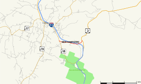
New Hampshire Route 141 (abbreviated NH 141) is a 2.172-mile-long (3.495 km) east–west state highway located entirely within the town of Franconia. Its western end is at New Hampshire Route 18. Its eastern end is at U.S. Route 3. It is called Butterhill Road for its entire length. The New Hampshire Department of Transportation maintains a major depot here for plows and maintenance equipment.
Major intersections
The entire route is in Franconia, Grafton County. [1][2]
| mi[1][2] | km | Destinations | Notes | ||
|---|---|---|---|---|---|
| 0.000 | 0.000 | Western terminus | |||
| 1.399– 1.778 | 2.251– 2.861 | Exit 36 on I-93 | |||
| 2.172 | 3.495 | Eastern terminus | |||
| 1.000 mi = 1.609 km; 1.000 km = 0.621 mi | |||||
References
- 1 2 3 Bureau of Planning & Community Assistance (February 20, 2015). "NH Public Roads". Concord, New Hampshire: New Hampshire Department of Transportation. Retrieved April 7, 2015.
- 1 2 Bureau of Planning & Community Assistance (April 3, 2015). "Nodal Reference 2015, State of New Hampshire". New Hampshire Department of Transportation. Retrieved April 7, 2015.
External links
This article is issued from Wikipedia - version of the 4/19/2015. The text is available under the Creative Commons Attribution/Share Alike but additional terms may apply for the media files.