Nevada State Route 518
| ||||
|---|---|---|---|---|
| Snyder Avenue | ||||
|
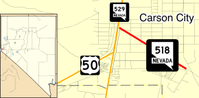
Nevada State Route 518, highlighted in red. | ||||
| Route information | ||||
| Maintained by NDOT | ||||
| Length: | 1.017 mi[1] (1.637 km) | |||
| Existed: | 1976 – present | |||
| Major junctions | ||||
| West end: |
| |||
| East end: | Jacobsen Way in Carson City | |||
| Highway system | ||||
| ||||

State Route 518 (SR 518) is a short state highway in Carson City, Nevada serving the state's Stewart Complex. The route originated as State Route 36.
Route description
_in_Carson_City%2C_Nevada.jpg)
State Route 518 begins at the intersection of Snyder Avenue and South Carson Street (U.S. Route 395 & U.S. Route 50) in southern Carson City. From there, the route heads southeast along the two-lane Snyder Avenue into lightly populated areas of the city. After a little more than a mile (1.6 km), the state highway comes to an end at Jacobsen Way, although Snyder Avenue continues southeast to serve rural areas.[2]
Located at the end of State Route 518 on Snyder Avenue is the State of Nevada's Stewart Complex. Opened in 1890, the facility was operated by the federal government as an Indian boarding school focusing on vocational skills. Originally, students were primarily from the Washo, Paiute and Shoshone Indian tribes, but the center eventually expanded to educate Indian students of all cultures across the United States. The federal government closed the school in 1980, with Nevada officials gradually acquiring the campus over the next several years. The site is now used as a state office and training facility, and is home to the Nevada Indian Commission and the Stewart Indian Museum and Trading Post.[3][4]
History
SR 518 has been in Nevada's state highway system since at least 1936. By this time, the highway was shown on Nevada maps as State Route 36, a paved road connecting US 395/US 50 to what was then labeled as the Carson Indian School.[5] The route designation stayed the same until July 1, 1976. On that date, Nevada officials began renumbering the state's highways, assigning State Route 518 to the road serving the Stewart school.[6] The route has remained relatively unchanged since.
Major intersections
The entire route is in Carson City.
| mi[1] | km | Destinations | Notes | ||
|---|---|---|---|---|---|
| 0.00 | 0.00 | ||||
| 1.04 | 1.67 | Jacobsen Way | Snyder Avenue continues beyond terminus | ||
| 1.000 mi = 1.609 km; 1.000 km = 0.621 mi | |||||
References
- 1 2 "State Maintained Highways of Nevada: Descriptions and Maps". Nevada Department of Transportation. January 2010. Retrieved 21 Feb 2010.
- ↑ Google (21 Feb 2010). "Overview of SR 518" (Map). Google Maps. Google. Retrieved 21 Feb 2010.
- ↑ Moreno, Richard (2000). Roadside History of Nevada. Missoula: Mountain Press Publishing Company. pp. 90–91. ISBN 0-87842-410-5.
- ↑ "Stewart History". Stewart Indian School. Retrieved 22 Feb 2010.
- ↑ Official Road Map of the State of Nevada (Map). Nevada Department of Highways. 1936. Retrieved 22 Feb 2010.
- ↑ Nevada State Maintained Highways: Descriptions, Index and Maps. Nevada Department of Transportation. January 2001. p. 96.